METAR & TAF KREG
Current METAR
Observed 22:35Z
KREG 262235Z AUTO 26005KT 10SM SCT055 35/24 A2998 RMK AO2 T03520236
- Wind
- 260° @ 5 kt
- Visibility
- 10 SM
- Temp / Dew
- 35°C / 24°C
- Altimeter
- 29.98 inHg
- Clouds
- SCT
- Density alt
- 2,343 ft
- Ceiling
- Unlimited
- Rules
- VFR
Airport info & contacts
Manager on record, flight service, ARTCC, attendance schedule and pattern altitude — published by the FAA and refreshed every 28 days.
Location
- From city
- 2 NM S
- VFR sectional
- NEW ORLEANS
- ARTCC
- ZHU · HOUSTON
- NOTAM facility
- DRI (NOTAM-D)
Airport manager
- Name
- JASON BALL
- Phone
- 225-644-1959
- Address
- 6255 AIRPORT INDUSTRIAL BLVD, GONZALES LA 70737
Flight service · Hours
- FSS DRI
- DE RIDDER1-800-WX-BRIEF
- Attendance
- 0800-1700
Frequencies
Tap any row to copy the frequency to your clipboard.
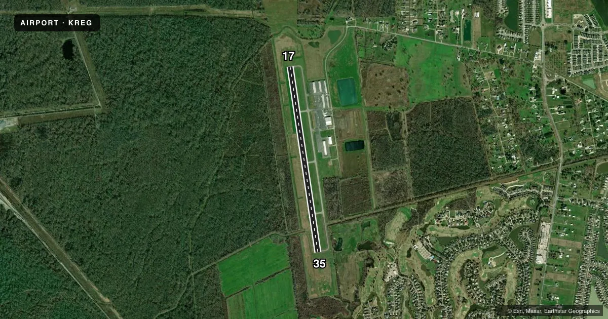
Runways & pattern
Full pagePattern entry · RWY 17
LEFT TRAFFICRunway end performance
| End | TORA | TODA | ASDA | LDA | VGSI | Approach lights | Obstruction |
|---|---|---|---|---|---|---|---|
| 17 | — | — | — | — | PAPI 2-box left(3°) | — | 97', trees, 2770' from thr, 96' R of cntrln, slope 26 |
| 35 | — | — | — | — | PAPI 2-box left(3°) | — | 51', trees, 1454' from thr, 50' R of cntrln, slope 24 |
Declared distances in feet. TORA = takeoff run available, TODA = takeoff distance, ASDA = accelerate-stop, LDA = landing distance.
Airport sketch
Runways drawn to scale from FAA survey coordinates, rendered over satellite imagery. Not for navigation.
Approaches & charts
Services on the field
Fuel grades, oxygen, maintenance, ramp storage and lighting — as declared to the FAA by the airport operator.
Fuel & services
- Fuel
- 100LLA+
- Airframe repair
- Minor
- Power plant repair
- Minor
- Other services
- CHTR,INSTR,RNTL
Ramp & ground
- Transient storage
- Tie-down
- Hangar
- Lighting schedule
- SEE RMK
- Beacon schedule
- SS-SR
- Beacon
- White / Green (civil land)(WG)
- Wind indicator
- Lighted
- Segmented circle
- Yes
Fuel & FBOs
Cheapest 100LL and Jet A on the field and nearby. Always confirm with the FBO before taxi.
Airport notes
Surface conditions, obstructions, local procedures, lighting outages and other notes published with each FAA cycle.
General notes
- GCO AVBL ON FREQ 135.075 THRU BATON ROUGE APCH & DE RIDDER FSS.
- DEER ON & INVOF ARPT.
- FOR CD IF UNA VIA GCO CTC BATON ROUGE APCH AT 225-354-2142 OR HOUSTON ARTCC AT 281-230-5622.
- CLIMB TO 800 AGL BFR L TURN ON DEP FROM RY 17 FOR NOISE
- CTC APRT MGR FOR DSGND RAMP SPACE FOR PUB USE.
Lighting notes
- DUSK-DAWN. MIRL RY 17/35 & REIL RYS 17 & 35 PRESET LOW INTST DUSK-DAWN; TO INCR INTST ACTVT - CTAF.
Fuel notes
- 100LL100LL AVBL SELF SVC WITH CREDIT CARD. JET A AVAILABLE AFTER HOURS CALL 225-644-1959
Other notes
- OWNERTRANSPORTATION AUTHORITY.
VFR map & nearby airports
VFR sectional. Tap any ICAO chip to open that airport.
Key facts · KREG
Answer card- ICAO
- KREG
- Name
- LOUISIANA RGNL
- Location
- GONZALES, LOUISIANA
- Elevation
- 14 ft MSL
- Traffic pattern altitude
- 1,014 ft MSL (1,000 AGL)
- Control tower
- Non-towered (use CTAF)
- Total runways
- 1
- Longest runway
- 17/35 · 5,003 ft
- Published ILS approaches
- 0
- Published frequencies
- 4
- Magnetic variation
- 2°
- Current flight rules
- VFR
- Current wind
- 260° at 5 kt
- Favored runway now
- RWY 17
Louisiana Rgnl (KREG) sits in Gonzales, Louisiana. The field elevation is 14 ft MSL. It has one runway, 17/35, which is 5,003 ft long. There is no control tower. No ILS approaches are published here, so plan with the current charted procedures and weather minimums in mind.
The published pattern altitude is not listed, so use the standard 1,000 ft AGL for light piston traffic unless the current Chart Supplement says otherwise. Deer are reported on and near the airport, so keep a sharp scan on taxi, takeoff and landing. Runway lighting is available from dusk to dawn. The runway lights and runway end identifier lights can be brightened from the CTAF.
Louisiana Regional Airport is the on-field FBO. It carries 100LL and Jet A. Self-serve 100LL is available with credit card. Jet A is available after hours by phone. For a first visit, note the noise abatement item on runway 17. Climb to 800 ft AGL before starting a left turn after departure. Ramp space for public use is designated by the airport manager, so call ahead if you need parking guidance. Baton Rouge Approach handles the area. Have the current frequencies and clearance plan ready before you go.