METAR & TAF KPTN
Current METAR
Observed 01:56Z
KPTN 270156Z AUTO 23005KT 10SM CLR 28/28 A3000 RMK AO2 SLP158 T02780278 $
- Wind
- 230° @ 5 kt
- Visibility
- 10 SM
- Temp / Dew
- 28°C / 28°C
- Altimeter
- 30.00 inHg
- Clouds
- CLR
- Density alt
- 1,471 ft
- Ceiling
- Unlimited
- Rules
- VFR
Airport info & contacts
Manager on record, flight service, ARTCC, attendance schedule and pattern altitude — published by the FAA and refreshed every 28 days.
Location
- From city
- 2 NM NW
- VFR sectional
- HOUSTON
- ARTCC
- ZHU · HOUSTON
- NOTAM facility
- PTN (NOTAM-D)
Airport manager
- Name
- PAUL J. GOVERNAK
- Phone
- 337-828-4100
- Address
- 500 MAIN ST, 5TH FLOOR COURTHOUSE, FRANKLIN LA 70538
Flight service · Hours
- FSS DRI
- DE RIDDER1-800-WX-BRIEF
- Attendance
- ALL
Frequencies
Tap any row to copy the frequency to your clipboard.
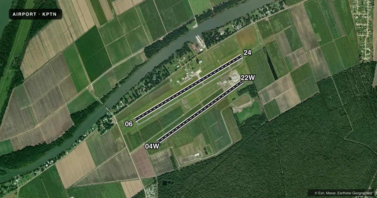
Runways & pattern
Full pagePattern entry · RWY 22W
LEFT TRAFFIC| Runway | Heading (°M) | Length | Surface | Traffic |
|---|---|---|---|---|
| 06/24 | 58° / 238° | 5,399 ft | ASPH | 24 R |
| 04W/22WFavored | 54° / 234° | 4,500 ft | WATER | 04W R |
Runway end performance
| End | TORA | TODA | ASDA | LDA | VGSI | Approach lights | Obstruction |
|---|---|---|---|---|---|---|---|
| 06 | — | — | — | — | PAPI 2-box left(3°) | — | 58', trees, 1491' from thr, 262' R of cntrln, slope 22 |
| 24 | — | — | — | — | PAPI 2-box left(3°) | MALSR | — |
| 04W | — | — | — | — | — | — | 20', road, 600' from thr, 0' R of cntrln, slope 30 |
Declared distances in feet. TORA = takeoff run available, TODA = takeoff distance, ASDA = accelerate-stop, LDA = landing distance.
Airport sketch
Runways drawn to scale from FAA survey coordinates, rendered over satellite imagery. Not for navigation.
Approaches & charts
ILS · 1
Services on the field
Fuel grades, oxygen, maintenance, ramp storage and lighting — as declared to the FAA by the airport operator.
Fuel & services
- Fuel
- 100LLA
- Oxygen (bottled)
- Not available
- Oxygen (bulk)
- Not available
- Airframe repair
- Major
- Power plant repair
- Major
- Other services
- AGRI,AVNCS,CHTR,INSTR
Ramp & ground
- Transient storage
- Tie-down
- Hangar
- Landing fee
- No fee published
- Customs
- Not available
- Lighting schedule
- SEE RMK
- Beacon schedule
- SS-SR
- Beacon
- White / Green (civil land)(WG)
- Wind indicator
- Lighted
- Segmented circle
- No
Fuel & FBOs
Cheapest 100LL and Jet A on the field and nearby. Always confirm with the FBO before taxi.
Airport notes
Surface conditions, obstructions, local procedures, lighting outages and other notes published with each FAA cycle.
General notes
- 4500 FT BY 100 FT WATERWAY HDG 04/22 LCTD 1100 FT SOUTH OF CONC RWY. DUAL LAND/SEA OPERATION.
- FOR CD CTC NEW ORLEANS APCH AT 504-471-4350 OR 124.3.
- PILOTS CONDUCTING EFVS OPS; BE AWARE LED ALS IN USE RWY 24.
- CTC ARPT MGR FOR DSNGD RAMP SPACE FOR PUB USE AT ARPT
Lighting notes
- ACTVT MALSR RWY 24; MIRL RWY 06/24 PRESET MED INTST, TO INCR INTST - CTAF.
Approach & departure obstructions
- 06APCH RATIO 23:1 TO DTHR.
VFR map & nearby airports
VFR sectional. Tap any ICAO chip to open that airport.
Key facts · KPTN
Answer card- ICAO
- KPTN
- Name
- HARRY P WILLIAMS MEML
- Location
- PATTERSON, LOUISIANA
- Elevation
- 8.5 ft MSL
- Traffic pattern altitude
- 1,008.5 ft MSL (1,000 AGL)
- Control tower
- Non-towered (use CTAF)
- Total runways
- 2
- Longest runway
- 06/24 · 5,399 ft
- Published ILS approaches
- 1
- Published frequencies
- 5
- Magnetic variation
- 1°
- Current flight rules
- VFR
- Current wind
- 230° at 5 kt
- Favored runway now
- RWY 22W
Harry P Williams Meml Airport is in Patterson, Louisiana. The field elevation is 8.5 ft MSL, so this is a low coastal airport with water operations nearby. There are two runways. The longest is runway 06/24 at 5,399 ft. The other runway is 04W/22W on water at 4,500 ft. There is no control tower. Traffic pattern altitude is not published. Use 1,000 ft AGL for light piston traffic unless local procedures or ATC say otherwise.
The airport has one ILS approach. It serves runway 24. Published remarks note LED approach lighting on 24. The runway 24 lighting system also has runway alignment indicator lights active. Medium intensity edge lights on 06 and 24 are preset. Use CTAF if you need to increase intensity. For clearance delivery, New Orleans Approach handles it on 124.3 or by phone. The airport also has dual land and sea operations. There is a waterway south of the concrete runway.
Perry Flying Center is on the field. It carries 100LL and Jet A. Pilots should also check ramp space with the airport manager before arrival. Runway 06 has a published 23 to 1 approach ratio to decision height. Review the current Chart Supplement before a first visit.