METAR & TAF L83
L83 does not publish a METAR.
Showing the nearest reporting station: KHUM (HOUMA-TERREBONNE) · 14.1 NM away. Conditions at L83 may differ.
METAR · KHUM
Observed 15:47Z
KHUM 191547Z 18008KT 7SM SCT027 23/26 A2997
- Wind
- 180° @ 8 kt
- Visibility
- 7 SM
- Temp / Dew
- 23°C / 26°C
- Altimeter
- 29.97 inHg
- Clouds
- SCT
- Density alt
- 909 ft
- Ceiling
- Unlimited
- Rules
- VFR
Airport info & contacts
Manager on record, flight service, ARTCC, attendance schedule and pattern altitude — published by the FAA and refreshed every 28 days.
Location
- From city
- 3 NM S
- VFR sectional
- NEW ORLEANS
- ARTCC
- ZHU · HOUSTON
- NOTAM facility
- DRI (NOTAM-D)
Airport manager
- Name
- SARAH ARCENAUX
- Phone
- 985-446-7208
- Address
- PO BOX 5418, THIBODAUX LA 70302-5418
Flight service · Hours
- FSS DRI
- DE RIDDER1-800-WX-BRIEF
- Attendance
- 0800-1700
Frequencies
Tap any row to copy the frequency to your clipboard.
Runways & pattern
Full pagePattern entry · RWY 26
LEFT TRAFFICRunway end performance
| End | TORA | TODA | ASDA | LDA | VGSI | Approach lights | Obstruction |
|---|---|---|---|---|---|---|---|
| 08 | — | — | — | — | — | — | 79', trees, 637' from thr, 132' R of cntrln, slope 5 |
| 26 | — | — | — | — | — | — | 73', trees, 1754' from thr, 130' R of cntrln, slope 21 |
Declared distances in feet. TORA = takeoff run available, TODA = takeoff distance, ASDA = accelerate-stop, LDA = landing distance.
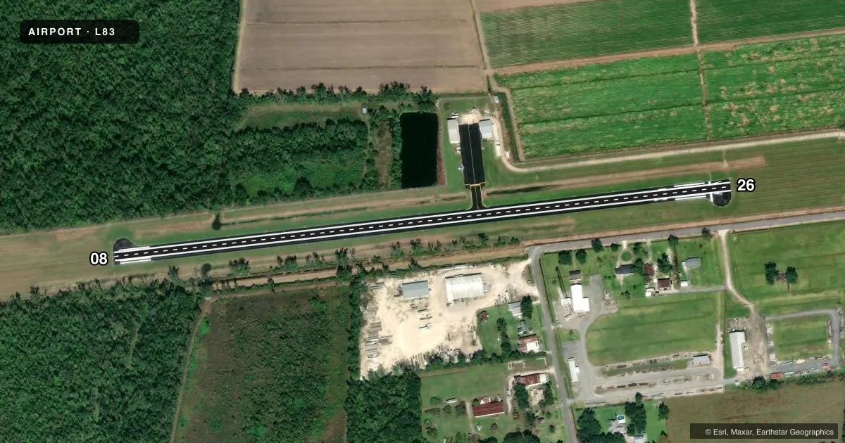
Airport sketch
Runways drawn to scale from FAA survey coordinates, rendered over satellite imagery. Not for navigation.
Approaches & charts
Services on the field
Fuel grades, oxygen, maintenance, ramp storage and lighting — as declared to the FAA by the airport operator.
Fuel & services
- Fuel
- 100LL
- Oxygen (bottled)
- Not available
- Oxygen (bulk)
- Not available
- Airframe repair
- Minor
- Power plant repair
- Minor
- Other services
- AGRI,SURV
Ramp & ground
- Transient storage
- Tie-down
- Landing fee
- No fee published
- Customs
- Not available
- Lighting schedule
- SEE RMK
- Beacon schedule
- SS-SR
- Beacon
- White / Green (civil land)(WG)
- Wind indicator
- Lighted
- Segmented circle
- No
Fuel & FBOs
Cheapest 100LL and Jet A on the field and nearby. Always confirm with the FBO before taxi.
Airport notes
Surface conditions, obstructions, local procedures, lighting outages and other notes published with each FAA cycle.
General notes
- RWY 08/26 AGRICULTURE WASHDOWN PAD 500 FT NORTH OF RWY AT MIDFLD.
- FOR CD CTC NEW ORLEANS APCH AT 504-471-4350.
- TREES 60 FT TALL; 160 FT NORTH AND SOUTH OF CNTRLN PENT THE 7:1 TRSNL SLP RWY 08.
- WILDLIFE ON OR NEAR THE RWY SAFETY AREA
- CTC ARPT MGR FOR DSNGD RAMP SPACE FOR PUB USE AT ARPT
Lighting notes
- REIL RWY 08/26; MIRL RWY 08/26 PRESET LOW INTST; TO INCR INTST ACTVT - CTAF.
Fuel notes
- 100LL100LL FUEL AVBL BY APPT CALL 985-209-4697
Approach & departure obstructions
- 26APCH RATIO 14:1 TO DSPLCD THR.
Other notes
- THIS AIRPORT HAS BEEN SURVEYED BY THE NATIONAL GEODETIC SURVEY.
- 1FOR ARPT ATND AFT HRS CALL 985-209-4697.
VFR map & nearby airports
VFR sectional. Tap any ICAO chip to open that airport.
Key facts · L83
Answer card- ICAO
- L83
- Name
- THIBODAUX MUNI
- Location
- THIBODAUX, LOUISIANA
- Elevation
- 9 ft MSL
- Traffic pattern altitude
- 1,009 ft MSL (1,000 AGL)
- Control tower
- Non-towered (use CTAF)
- Total runways
- 1
- Longest runway
- 08/26 · 2,999 ft
- Published ILS approaches
- 0
- Published frequencies
- 4
- Magnetic variation
- 2°
- Current flight rules
- VFR
- Current wind
- 180° at 8 kt
- Favored runway now
- RWY 26
Thibodaux Muni is in Thibodaux, Louisiana. The field elevation is 9 ft MSL. It has one runway, 08/26, at 2,999 ft asphalt. There is no control tower. Pattern altitude is not published, so verify the current Chart Supplement before you fly. No ILS approaches are published here.
Golden Ranch Aviation is on the field. It carries 100LL. Fuel is available by appointment. Call the number in the Chart Supplement or the FBO directly before arrival. The airport remarks also note runway end identifier lights on 08/26. The runway lights are preset to low intensity. You can increase intensity by keying the CTAF.
For a first visit, pay attention to the runway environment. Wildlife is reported on or near the runway safety area. Trees 60 ft tall sit north and south of the centerline and penetrate the transitional surface for runway 08. Runway 26 also has a displaced threshold with a published 14 to 1 approach ratio. Clearance delivery is handled through New Orleans Approach. Contact them if you need IFR clearance. Ramp space for public use is assigned by the airport manager. Check ahead if you need parking. This is a low-elevation field with a short runway. Plan your performance with the actual weight, temperature and wind in mind.