METAR & TAF KAPS
Current METAR
Observed 11:55Z
KAPS 271155Z AUTO 10SM CLR 25/25 A3000 RMK AO2 T02530250 10265 20247
- Wind
- Calm
- Visibility
- 10 SM
- Temp / Dew
- 25°C / 25°C
- Altimeter
- 30.00 inHg
- Clouds
- CLR
- Density alt
- 1,109 ft
- Ceiling
- Unlimited
- Rules
- VFR
Airport info & contacts
Manager on record, flight service, ARTCC, attendance schedule and pattern altitude — published by the FAA and refreshed every 28 days.
Location
- From city
- 2 NM NW
- VFR sectional
- NEW ORLEANS
- ARTCC
- ZHU · HOUSTON
- NOTAM facility
- APS (NOTAM-D)
Airport manager
- Name
- CHANSE P WATSON
- Phone
- 985-536-1999
- Address
- 355 AIRPORT ROAD, RESERVE LA 70084
Flight service · Hours
- FSS DRI
- DE RIDDER1-800-WX-BRIEF
- Attendance
- MON-FRI · 0700-1700
- SAT-SUN · 0700-1200
Frequencies
Tap any row to copy the frequency to your clipboard.
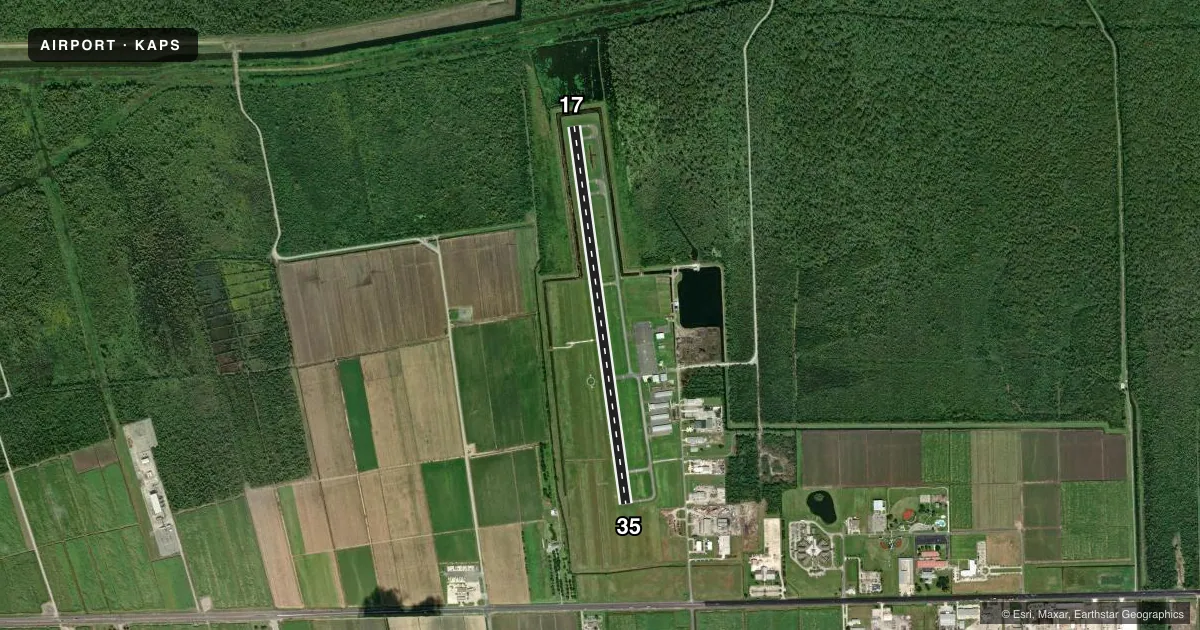
Runways & pattern
Full pagePattern entry · RWY 17
LEFT TRAFFICRunway end performance
| End | TORA | TODA | ASDA | LDA | VGSI | Approach lights | Obstruction |
|---|---|---|---|---|---|---|---|
| 17 | — | — | — | — | PAPI 2-box left(3°) | — | 75', trees, 1725' from thr, 0' R of cntrln, slope 20 |
| 35 | — | — | — | — | PAPI 2-box left(3°) | — | — |
Declared distances in feet. TORA = takeoff run available, TODA = takeoff distance, ASDA = accelerate-stop, LDA = landing distance.
Airport sketch
Runways drawn to scale from FAA survey coordinates, rendered over satellite imagery. Not for navigation.
Approaches & charts
Services on the field
Fuel grades, oxygen, maintenance, ramp storage and lighting — as declared to the FAA by the airport operator.
Fuel & services
- Fuel
- 100LLAA+
- Oxygen (bottled)
- Not available
- Oxygen (bulk)
- Not available
- Airframe repair
- Not available
- Power plant repair
- Not available
- Other services
- INSTR,RNTL
Ramp & ground
- Transient storage
- Tie-down
- Hangar
- Lighting schedule
- SEE RMK
- Beacon schedule
- SS-SR
- Beacon
- White / Green (civil land)(WG)
- Wind indicator
- Lighted
- Segmented circle
- Yes
Fuel & FBOs
Cheapest 100LL and Jet A on the field and nearby. Always confirm with the FBO before taxi.
Airport notes
Surface conditions, obstructions, local procedures, lighting outages and other notes published with each FAA cycle.
General notes
- ULTRALIGHT ACT.
- BIRDS ON AND INVOF ARPT.
- FOR CD CTC NEW ORLEANS APCH AT 504-471-4350.
- FOR TSNT GA CUSTOMERS NOT REQUIRING FBO SVC, PLEASE PARK N OF THE WHITE LINE.
- TWY A UNLIT.
Lighting notes
- REIL RWY 17 & 35; MIRL RWY 17/35 PRESET LOW INTST; TO INCR INTST ACTVT - CTAF.
Approach & departure obstructions
- 17APCH SLOPE 22:1 TO THE DSPLCD THLD.
Other notes
- 1SELF SER 24 HRS. FULL SER WKEND & AFT HRS OPS BY RQ.
- MANAGERAIRPORT PHYS. ADDRESS: 355 AIRPORT RD., RESERVE, LA 70084
- MANAGERAFT HRS - 985-652-9278 EXT 1121
- OWNERFBO CTR 985-652-9278 #8512 OR 8510.
VFR map & nearby airports
VFR sectional. Tap any ICAO chip to open that airport.
Key facts · KAPS
Answer card- ICAO
- KAPS
- Name
- PORT OF SOUTH LOUISIANA EXEC RGNL
- Location
- RESERVE, LOUISIANA
- Elevation
- 6.5 ft MSL
- Traffic pattern altitude
- 1,006.5 ft MSL (1,000 AGL)
- Control tower
- Non-towered (use CTAF)
- Total runways
- 1
- Longest runway
- 17/35 · 5,151 ft
- Published ILS approaches
- 0
- Published frequencies
- 4
- Magnetic variation
- 1°
- Current flight rules
- VFR
- Current wind
- Calm / unavailable
- Favored runway now
- –
Port of South Louisiana Executive Regional Airport sits in Reserve, Louisiana. Field elevation is 6.5 ft MSL. The airport has one runway, 17/35, at 5,151 ft. It is not towered. CTAF and UNICOM are both 122.7. New Orleans Approach handles approach and departure on 125.5 or 350.35. No ILS approaches are published here.
Pattern altitude is not published. Use 1,000 ft AGL for light piston traffic unless the current Chart Supplement says otherwise. The on-field FBO is Port of South Louisiana Executive Regional Airport. It carries AVGAS 100LL, Jet A and Jet A Prist. Self-service is available 24 hours. Full service is available on weekends and after hours by request. The field also has runway end identifier lights on 17 and 35. Medium intensity runway lights start at low intensity on 17/35. Use the CTAF to increase intensity.
A few operational notes matter here. Taxiway A is unlit. Birds are reported on and near the airport. Ultralight activity also occurs here. There is an approach slope note for runway 17 to the displaced threshold. Transient GA aircraft not needing FBO service should park north of the white line. For clearances, contact New Orleans Approach. Check the current Chart Supplement for any published noise or curfew restrictions before flying into the field.