METAR & TAF T36
T36 does not publish a METAR.
Showing the nearest reporting station: KMCB (MC COMB/PIKE COUNTY/JOHN E LEWIS FLD) · 15.7 NM away. Conditions at T36 may differ.
METAR · KMCB
Observed 05:53Z
KMCB 270553Z AUTO 00000KT 10SM CLR 26/23 A3000 RMK AO2 SLP152 T02560228 10328 20239 403500239 50007
- Wind
- 000° @ 0 kt
- Visibility
- 10 SM
- Temp / Dew
- 26°C / 23°C
- Altimeter
- 30.00 inHg
- Clouds
- CLR
- Density alt
- 1,697 ft
- Ceiling
- Unlimited
- Rules
- VFR
Airport info & contacts
Manager on record, flight service, ARTCC, attendance schedule and pattern altitude — published by the FAA and refreshed every 28 days.
Location
- From city
- 3 NM NW
- VFR sectional
- NEW ORLEANS
- ARTCC
- ZHU · HOUSTON
- NOTAM facility
- GWO (NOTAM-D)
Airport manager
- Name
- MITCH HOBGOOD
- Phone
- 601-814-9021
- Address
- 141 AIRPORT RD, TYLERTOWN MS 39667
Flight service · Hours
- FSS GWO
- GREENWOOD1-800-WX-BRIEF
- Attendance
- Unattended
Frequencies
Tap any row to copy the frequency to your clipboard.
Runways & pattern
Full pagePattern entry · RWY 18
LEFT TRAFFICRunway end performance
| End | TORA | TODA | ASDA | LDA | VGSI | Approach lights | Obstruction |
|---|---|---|---|---|---|---|---|
| 18 | — | — | — | — | PAPI 2-box left(3.5°) | — | 38', trees, 1650' from thr, 200' R of cntrln, slope 38 |
| 36 | — | — | — | — | PAPI 2-box left(3°) | — | — |
Declared distances in feet. TORA = takeoff run available, TODA = takeoff distance, ASDA = accelerate-stop, LDA = landing distance.
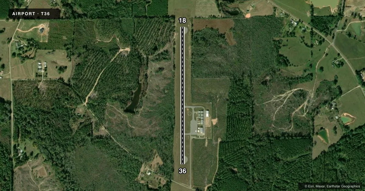
Airport sketch
Runways drawn to scale from FAA survey coordinates, rendered over satellite imagery. Not for navigation.
Approaches & charts
Services on the field
Fuel grades, oxygen, maintenance, ramp storage and lighting — as declared to the FAA by the airport operator.
Fuel & services
- Fuel
- 100LL
- Oxygen (bottled)
- Not available
- Oxygen (bulk)
- Not available
Ramp & ground
- Transient storage
- Tie-down
- Landing fee
- No fee published
- Customs
- Not available
- Lighting schedule
- SEE RMK
- Beacon schedule
- SS-SR
- Beacon
- White / Green (civil land)(WG)
- Wind indicator
- Lighted
- Segmented circle
- Yes
Fuel & FBOs
Cheapest 100LL and Jet A on the field and nearby. Always confirm with the FBO before taxi.
Airport notes
Surface conditions, obstructions, local procedures, lighting outages and other notes published with each FAA cycle.
General notes
- FOR CD CTC HOUSTON ARTCC AT 281-230-5622.
- WILDLIFE ON & INVOF ARPT.
Lighting notes
- ACTVT MIRL RWY 18/36 - CTAF. PAPI RWY 18 & 36 OPR CONSLY.
Fuel notes
- 100LLFUEL AVBL 24 HRS WITH CREDIT CARD.
Approach & departure obstructions
- 18PAPI UNUSBL BYD 7 DEGS LEFT & 9 DEGS RIGHT OF CNTRLN.
Other notes
- PILOTS MUST PRVD THEIR OWN TIEDOWN ROPES.
VFR map & nearby airports
VFR sectional. Tap any ICAO chip to open that airport.
Key facts · T36
Answer card- ICAO
- T36
- Name
- PAUL PITTMAN MEML
- Location
- TYLERTOWN, MISSISSIPPI
- Elevation
- 384.2 ft MSL
- Traffic pattern altitude
- 1,384.2 ft MSL (1,000 AGL)
- Control tower
- Non-towered (use CTAF)
- Total runways
- 1
- Longest runway
- 18/36 · 3,023 ft
- Published ILS approaches
- 0
- Published frequencies
- 2
- Magnetic variation
- 3°
- Current flight rules
- VFR
- Current wind
- 000° at 0 kt
- Favored runway now
- –
Paul Pittman Meml is in Tylertown, Mississippi. Field elevation is 384.2 ft MSL. The airport has one runway. Runway 18/36 is 3,023 ft long with asphalt pavement. There is no control tower. CTAF and UNICOM are both 122.8.
No ILS approaches are published here. Pattern altitude is not published. Use the standard 1,000 ft AGL pattern for light piston operations unless the current Chart Supplement says otherwise. That puts the traffic pattern at about 1,384 ft MSL based on the field elevation.
Walthall County Airport is the on-field FBO. It carries AVGAS 100LL. Fuel is available 24 hours with a credit card. The published remarks also say pilots must bring their own tiedown ropes. Medium intensity runway lights for 18/36 are activated by using the common traffic advisory frequency. The PAPI for both runway directions operates continuously.
This is an uncontrolled field, so listen carefully on 122.8 and make your calls early. For IFR clearance delivery, contact Houston ARTCC at 281-230-5622. If you need current noise, lighting, or airport-use details before departure, check the current FAA Chart Supplement or call the airport operator directly.