METAR & TAF 1R7
Current METAR
Observed 05:15Z
K1R7 270515Z AUTO 00000KT 9SM CLR A3001 RMK A01 TSNO
- Wind
- 000° @ 0 kt
- Visibility
- 9 SM
- Temp / Dew
- —
- Altimeter
- 30.01 inHg
- Clouds
- CLR
- Density alt
- —
- Ceiling
- Unlimited
- Rules
- VFR
Airport info & contacts
Manager on record, flight service, ARTCC, attendance schedule and pattern altitude — published by the FAA and refreshed every 28 days.
Location
- From city
- 3 NM NE
- VFR sectional
- NEW ORLEANS
- ARTCC
- ZHU · HOUSTON
- NOTAM facility
- GWO (NOTAM-D)
Airport manager
- Name
- JOHN COLEMAN
- Phone
- 601-833-0999
- Address
- 1216 HEUCKS RETREAT RD, BROOKHAVEN MS 39601
Flight service · Hours
- FSS GWO
- GREENWOOD1-800-WX-BRIEF
- Attendance
- MON-FRI · 0900-1700
Frequencies
Tap any row to copy the frequency to your clipboard.
Runways & pattern
Full pagePattern entry · RWY 05
LEFT TRAFFICRunway end performance
| End | TORA | TODA | ASDA | LDA | VGSI | Approach lights | Obstruction |
|---|---|---|---|---|---|---|---|
| 05 | — | — | — | — | PAPI 2-box left(3°) | — | 45', trees, 800' from thr, 100' R of cntrln, slope 13 |
| 23 | — | — | — | — | PAPI 2-box left(3°) | — | 53', trees, 800' from thr, 50' R of cntrln, slope 11 |
Declared distances in feet. TORA = takeoff run available, TODA = takeoff distance, ASDA = accelerate-stop, LDA = landing distance.
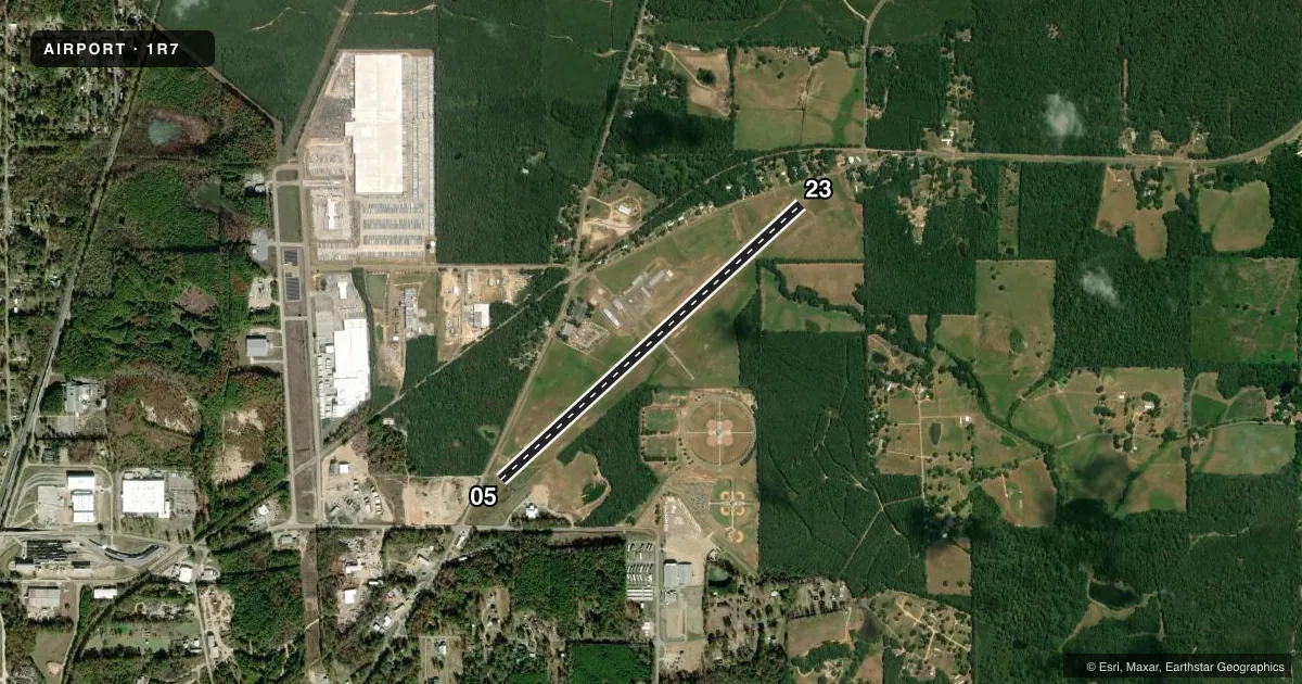
Airport sketch
Runways drawn to scale from FAA survey coordinates, rendered over satellite imagery. Not for navigation.
Approaches & charts
Services on the field
Fuel grades, oxygen, maintenance, ramp storage and lighting — as declared to the FAA by the airport operator.
Fuel & services
- Fuel
- 100LLA+
- Oxygen (bottled)
- Not available
- Oxygen (bulk)
- Not available
- Airframe repair
- Not available
- Power plant repair
- Not available
Ramp & ground
- Transient storage
- Tie-down
- Landing fee
- No fee published
- Customs
- Not available
- Lighting schedule
- SEE RMK
- Beacon schedule
- SS-SR
- Beacon
- White / Green (civil land)(WG)
- Wind indicator
- Lighted
- Segmented circle
- Yes
Fuel & FBOs
Cheapest 100LL and Jet A on the field and nearby. Always confirm with the FBO before taxi.
Airport notes
Surface conditions, obstructions, local procedures, lighting outages and other notes published with each FAA cycle.
General notes
- FOR CD CTC HOUSTON ARTCC AT 281-230-5622.
- COURTESY VEHICLE AVBL.
Lighting notes
- ACTVT MIRL RWY 05/23 - CTAF. PAPI RWY 05 OPR DUSK-DAWN. PAPI RWY 23 OPR CONSLY.
Fuel notes
- 100LLFUEL SVC AVBL 24 HRS WITH CREDIT CARD.
Approach & departure obstructions
- 23TALL TREES AER.
- 05APCH RATIO 31:1 FM DTHR.
- 23APCH RATIO 33:1 FM DTHR.
Other notes
- WIND INDICATOR LGT OPR DUSK-DAWN.
- MANAGERALTN CTC LARRY JOINTER, MAYOR.
VFR map & nearby airports
VFR sectional. Tap any ICAO chip to open that airport.
Key facts · 1R7
Answer card- ICAO
- 1R7
- Name
- BROOKHAVEN-LINCOLN COUNTY
- Location
- BROOKHAVEN, MISSISSIPPI
- Elevation
- 492.3 ft MSL
- Traffic pattern altitude
- 1,492.3 ft MSL (1,000 AGL)
- Control tower
- Non-towered (use CTAF)
- Total runways
- 1
- Longest runway
- 05/23 · 5,000 ft
- Published ILS approaches
- 0
- Published frequencies
- 2
- Magnetic variation
- 1°
- Current flight rules
- VFR
- Current wind
- 000° at 0 kt
- Favored runway now
- –
Brookhaven-Lincoln County Airport is in Brookhaven, Mississippi. The field elevation is 492.3 ft MSL. It has one runway. Runway 05/23 is 5,000 ft of asphalt, which is the longest runway on the field. There is no control tower. CTAF and UNICOM are both 122.8.
No ILS approaches are published here. Pattern altitude is not published, so use the standard 1,000 ft AGL for light piston traffic unless the current FAA Chart Supplement says otherwise. The airport sits in a non-towered environment, so expect self-announce traffic and keep a close ear on 122.8.
The on-field FBO is Brookhaven-Lincoln County Airport. It carries 100LL and Jet A. Fuel service is available 24 hours with credit card. A courtesy vehicle is available. The published remarks also note that the runway 05/23 lights are activated by the CTAF. The PAPI on runway 05 operates from dusk to dawn. The PAPI on runway 23 operates continuously. Tall trees are near the approach end of runway 23, so plan that end carefully. For clearance delivery, contact Houston ARTCC at 281-230-5622 before departure if you need it.