METAR & TAF 17M
17M does not publish a METAR.
Showing the nearest reporting station: KJAN (JACKSON-MEDGAR WILEY EVERS INTL) · 30.3 NM away. Conditions at 17M may differ.
METAR · KJAN
Observed 07:54Z
KJAN 270754Z AUTO 00000KT 10SM CLR 27/24 A2995 RMK AO2 SLP135 T02670239 $
- Wind
- 000° @ 0 kt
- Visibility
- 10 SM
- Temp / Dew
- 27°C / 24°C
- Altimeter
- 29.95 inHg
- Clouds
- CLR
- Density alt
- 2,092 ft
- Ceiling
- Unlimited
- Rules
- VFR
Airport info & contacts
Manager on record, flight service, ARTCC, attendance schedule and pattern altitude — published by the FAA and refreshed every 28 days.
Location
- From city
- 3 NM W
- VFR sectional
- NEW ORLEANS
- ARTCC
- ZME · MEMPHIS
- NOTAM facility
- GWO (NOTAM-D)
Airport manager
- Name
- DAVID MOORE
- Phone
- 601-382-3191
- Address
- 123 NORTH MAIN, MAGEE MS 39111
Flight service · Hours
- FSS GWO
- GREENWOOD1-800-WX-BRIEF
- Attendance
- MON-FRI · 0700-1200
Frequencies
Tap any row to copy the frequency to your clipboard.
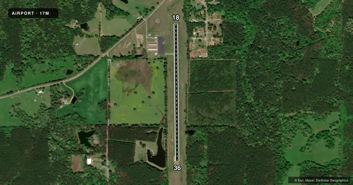
Runways & pattern
Full pagePattern entry · RWY 18
LEFT TRAFFICRunway end performance
| End | TORA | TODA | ASDA | LDA | VGSI | Approach lights | Obstruction |
|---|---|---|---|---|---|---|---|
| 18 | — | — | — | — | PAPI 2-box left(3°) | — | 50', trees, 1250' from thr, 250' R of cntrln, slope 21 |
| 36 | — | — | — | — | — | — | 80', trees, 2500' from thr, 0' R of cntrln, slope 28 |
Declared distances in feet. TORA = takeoff run available, TODA = takeoff distance, ASDA = accelerate-stop, LDA = landing distance.
Airport sketch
Runways drawn to scale from FAA survey coordinates, rendered over satellite imagery. Not for navigation.
Approaches & charts
Services on the field
Fuel grades, oxygen, maintenance, ramp storage and lighting — as declared to the FAA by the airport operator.
Fuel & services
- Fuel
- 100LL
- Oxygen (bottled)
- Not available
- Oxygen (bulk)
- Not available
- Airframe repair
- Not available
- Power plant repair
- Not available
Ramp & ground
- Transient storage
- Tie-down
- Hangar
- Landing fee
- No fee published
- Customs
- Not available
- Lighting schedule
- SEE RMK
- Beacon schedule
- SS-SR
- Beacon
- White / Green (civil land)(WG)
- Wind indicator
- Lighted
- Segmented circle
- Yes
Fuel & FBOs
Cheapest 100LL and Jet A on the field and nearby. Always confirm with the FBO before taxi.
Airport notes
Surface conditions, obstructions, local procedures, lighting outages and other notes published with each FAA cycle.
General notes
- RWY 36 4 FT DEEP DITCH 250 FT FM THR.
- FOR CD CTC MEMPHIS ARTCC AT 901-368-8453/8449.
Lighting notes
- ACTVT MIRL RWY 18/36 - CTAF.
Fuel notes
- 100LLFUEL AVBL 24 HRS WITH CREDIT CARD.
VFR map & nearby airports
VFR sectional. Tap any ICAO chip to open that airport.
Key facts · 17M
Answer card- ICAO
- 17M
- Name
- MAGEE MUNI
- Location
- MAGEE, MISSISSIPPI
- Elevation
- 555.8 ft MSL
- Traffic pattern altitude
- 1,555.8 ft MSL (1,000 AGL)
- Control tower
- Non-towered (use CTAF)
- Total runways
- 1
- Longest runway
- 18/36 · 3,103 ft
- Published ILS approaches
- 0
- Published frequencies
- 2
- Magnetic variation
- 1°
- Current flight rules
- VFR
- Current wind
- 000° at 0 kt
- Favored runway now
- –
Magee Muni sits in Magee, Mississippi. The field elevation is 555.8 ft MSL. It has one runway, 18/36, which is 3,103 ft long. There is no control tower. Pattern altitude is not published. Use the standard 1,000 ft AGL pattern for light piston traffic unless local guidance says otherwise.
No ILS approaches are published here. The runway is asphalt with magnetic headings of 179° and 359°. Runway 36 has a 4 ft deep ditch about 250 ft from the threshold. That is worth keeping in mind on arrival and departure planning. Medium intensity runway lights are available on 18/36. They are activated by using CTAF 122.8.
Magee Municipal Airport is the on-field FBO. It carries AVGAS 100LL. Fuel is available 24 hours with credit card. For clearance delivery, contact Memphis ARTCC before departure. If you are flying in at night or in marginal weather, verify current field conditions and any local procedures with the airport operator or the FBO directly by phone before you go.