METAR & TAF 2M4
2M4 does not publish a METAR.
Showing the nearest reporting station: KJAN (JACKSON-MEDGAR WILEY EVERS INTL) · 29.9 NM away. Conditions at 2M4 may differ.
METAR · KJAN
Observed 07:54Z
KJAN 270754Z AUTO 00000KT 10SM CLR 27/24 A2995 RMK AO2 SLP135 T02670239 $
- Wind
- 000° @ 0 kt
- Visibility
- 10 SM
- Temp / Dew
- 27°C / 24°C
- Altimeter
- 29.95 inHg
- Clouds
- CLR
- Density alt
- 2,045 ft
- Ceiling
- Unlimited
- Rules
- VFR
Airport info & contacts
Manager on record, flight service, ARTCC, attendance schedule and pattern altitude — published by the FAA and refreshed every 28 days.
Location
- From city
- 1 NM S
- VFR sectional
- MEMPHIS
- ARTCC
- ZME · MEMPHIS
- NOTAM facility
- GWO (NOTAM-D)
Airport manager
- Name
- ADAM TAYLOR
- Phone
- 601-900-8255
- Address
- CITY OF FOREST, PO BOX 298, FOREST MS 39074
Flight service · Hours
- FSS GWO
- GREENWOOD1-800-WX-BRIEF
- Attendance
- Unattended
Frequencies
Tap any row to copy the frequency to your clipboard.
Runways & pattern
Full pagePattern entry · RWY 17
LEFT TRAFFICRunway end performance
| End | TORA | TODA | ASDA | LDA | VGSI | Approach lights | Obstruction |
|---|---|---|---|---|---|---|---|
| 17 | — | — | — | — | — | — | 50', trees, 1500' from thr, slope 26 |
| 35 | — | — | — | — | — | — | 59', tree, 1200' from thr, slope 16 |
Declared distances in feet. TORA = takeoff run available, TODA = takeoff distance, ASDA = accelerate-stop, LDA = landing distance.
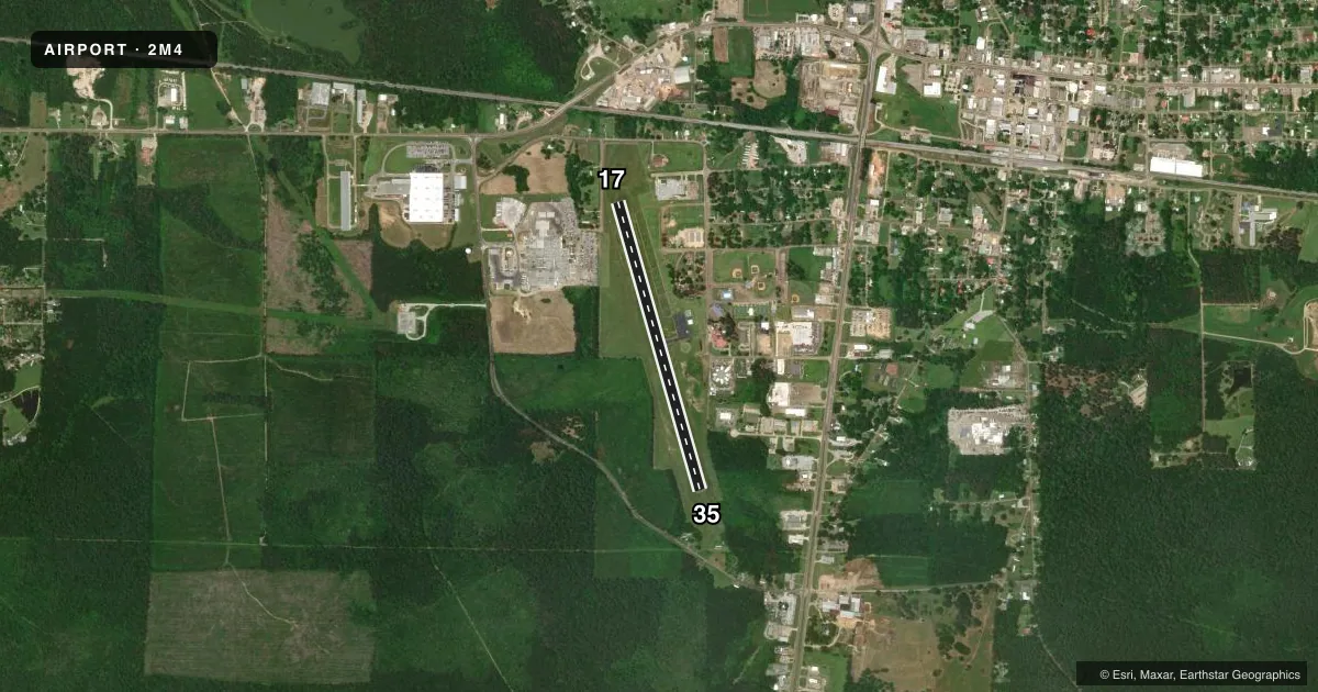
Airport sketch
Runways drawn to scale from FAA survey coordinates, rendered over satellite imagery. Not for navigation.
Approaches & charts
Services on the field
Fuel grades, oxygen, maintenance, ramp storage and lighting — as declared to the FAA by the airport operator.
Fuel & services
- Fuel
- Not available
- Oxygen (bottled)
- Not available
- Oxygen (bulk)
- Not available
- Airframe repair
- Not available
- Power plant repair
- Not available
Ramp & ground
- Transient storage
- Tie-down
- Landing fee
- No fee published
- Customs
- Not available
- Lighting schedule
- SEE RMK
- Beacon schedule
- SS-SR
- Beacon
- White / Green (civil land)(WG)
- Wind indicator
- Lighted
- Segmented circle
- Yes
Fuel & FBOs
Cheapest 100LL and Jet A on the field and nearby. Always confirm with the FBO before taxi.
Airport notes
Surface conditions, obstructions, local procedures, lighting outages and other notes published with each FAA cycle.
General notes
- FOR CD CTC MEMPHIS ARTCC AT 901-368-8453/8449.
Lighting notes
- MIRL RWY 17/35 OPR CONSLY 1700-2200; AFT 2200 ACTVT MIRL RWY 17/35 - CTAF.
Other notes
- PILOTS MUST PRVD TIEDOWN ROPES.
VFR map & nearby airports
VFR sectional. Tap any ICAO chip to open that airport.
Key facts · 2M4
Answer card- ICAO
- 2M4
- Name
- G V MONTGOMERY
- Location
- FOREST, MISSISSIPPI
- Elevation
- 518.3 ft MSL
- Traffic pattern altitude
- 1,518.3 ft MSL (1,000 AGL)
- Control tower
- Non-towered (use CTAF)
- Total runways
- 1
- Longest runway
- 17/35 · 3,602 ft
- Published ILS approaches
- 0
- Published frequencies
- 2
- Magnetic variation
- 2°
- Current flight rules
- VFR
- Current wind
- 000° at 0 kt
- Favored runway now
- –
G V Montgomery Airport is in Forest, Mississippi. Field elevation is 518.3 ft MSL. The airport has one runway. Runway 17/35 is 3,602 ft of asphalt, so plan your performance with the full length in mind. There is no control tower. CTAF and UNICOM are both 122.8.
No ILS approaches are published here. Pattern altitude is not published, so use the standard 1,000 ft AGL for light piston operations unless the current FAA Chart Supplement says otherwise. That puts the traffic pattern at about 1,518 ft MSL based on the field elevation. The published remarks also note that pilots must provide tiedown ropes. Runway lights on 17/35 operate continuously from 1700 to 2200. After 2200, you activate the medium intensity runway lights on 17/35 from the CTAF.
There are no on-field FBOs listed in the facts. Contact the airport operator directly or call the field on CTAF for current service details before you go. For clearance delivery, Memphis ARTCC can be reached at 901-368-8453 or 901-368-8449. If you are planning a night arrival or a departure after sunset, make sure you know how to work the lights and verify current airport status before launch.