METAR & TAF M23
M23 does not publish a METAR.
Showing the nearest reporting station: KMEI (KEY FLD) · 19.5 NM away. Conditions at M23 may differ.
METAR · KMEI
Observed 12:58Z
KMEI 271258Z 00000KT 10SM CLR 27/24 A2999 RMK AO2 SLP150 T02670239
- Wind
- 000° @ 0 kt
- Visibility
- 10 SM
- Temp / Dew
- 27°C / 24°C
- Altimeter
- 29.99 inHg
- Clouds
- CLR
- Density alt
- 1,812 ft
- Ceiling
- Unlimited
- Rules
- VFR
Airport info & contacts
Manager on record, flight service, ARTCC, attendance schedule and pattern altitude — published by the FAA and refreshed every 28 days.
Location
- From city
- 1 NM SE
- VFR sectional
- MEMPHIS
- ARTCC
- ZME · MEMPHIS
- NOTAM facility
- GWO (NOTAM-D)
Airport manager
- Name
- HOOPER WEEMS
- Phone
- 601-357-0213
- Address
- PO BOX 300, NEWTON MS 39345
Flight service · Hours
- FSS GWO
- GREENWOOD1-800-WX-BRIEF
- Attendance
- ON CALL
Frequencies
Tap any row to copy the frequency to your clipboard.
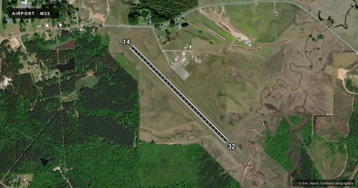
Runways & pattern
Full pagePattern entry · RWY 14
LEFT TRAFFICRunway end performance
| End | TORA | TODA | ASDA | LDA | VGSI | Approach lights | Obstruction |
|---|---|---|---|---|---|---|---|
| 14 | — | — | — | — | PSIL | — | 68', trees, 900' from thr, 200' R of cntrln, slope 10 |
| 32 | — | — | — | — | PSIL(7°) | — | 109', trees, 2600' from thr, 300' R of cntrln, slope 22 |
Declared distances in feet. TORA = takeoff run available, TODA = takeoff distance, ASDA = accelerate-stop, LDA = landing distance.
Airport sketch
Runways drawn to scale from FAA survey coordinates, rendered over satellite imagery. Not for navigation.
Approaches & charts
Services on the field
Fuel grades, oxygen, maintenance, ramp storage and lighting — as declared to the FAA by the airport operator.
Fuel & services
- Fuel
- 100LL
- Oxygen (bottled)
- Not available
- Oxygen (bulk)
- Not available
- Airframe repair
- Major
- Power plant repair
- Major
Ramp & ground
- Transient storage
- Tie-down
- Landing fee
- No fee published
- Customs
- Not available
- Lighting schedule
- SEE RMK
- Beacon schedule
- SS-SR
- Beacon
- White / Green (civil land)(WG)
- Wind indicator
- Lighted
- Segmented circle
- Yes
Fuel & FBOs
Cheapest 100LL and Jet A on the field and nearby. Always confirm with the FBO before taxi.
Airport notes
Surface conditions, obstructions, local procedures, lighting outages and other notes published with each FAA cycle.
General notes
- FOR CD CTC MERIDIAN APCH 601-679-3691, WHEN MERIDIAN APCH CLSD CTC MEMPHIS ARTCC AT 901-368-8453/8449.
- COURTESY CAR AVBL.
Lighting notes
- ACTVT MIRL RWY 14/32 - CTAF. PAPI RWY 32 OPR CONSLY.
Fuel notes
- 100LL24 HR FUEL AVBL WITH CREDIT CARD.
Approach & departure obstructions
- 14MKGS FADED.
- 32MKGS FADED.
Other notes
- TO SKED, CALL 601-357-0115; ALSO FOR PWR PLANT RPRS.
- PILOTS MUST PRVD THEIR OWN TIEDOWN ROPES.
- 1CALL 601-357-0213.
- 1FOR ATTENDANT AFT HRS & EMERG ONLY CALL 601-357-0213.
- OWNERTHE HONORABLE JAY POWELL, MAYOR OF NEWTON.
VFR map & nearby airports
VFR sectional. Tap any ICAO chip to open that airport.
Key facts · M23
Answer card- ICAO
- M23
- Name
- JAMES H EASOM FLD
- Location
- NEWTON, MISSISSIPPI
- Elevation
- 370 ft MSL
- Traffic pattern altitude
- 1,370 ft MSL (1,000 AGL)
- Control tower
- Non-towered (use CTAF)
- Total runways
- 1
- Longest runway
- 14/32 · 3,000 ft
- Published ILS approaches
- 0
- Published frequencies
- 2
- Magnetic variation
- 2°
- Current flight rules
- VFR
- Current wind
- 000° at 0 kt
- Favored runway now
- –
James H Easom Fld is in Newton, Mississippi. The field elevation is 370 ft MSL. It has one runway. Runway 14/32 is 3,000 ft long with asphalt pavement. There is no control tower. CTAF and UNICOM are both 122.8.
No ILS approaches are published here. The pattern altitude is not published, so use the standard 1,000 ft AGL for light piston operations unless the current Chart Supplement says otherwise. The published remarks matter here. 100LL is available with 24-hour credit card self-serve. Pilots must bring their own tiedown ropes. Runway lights on 14/32 are activated by CTAF. The PAPI for runway 32 operates continuously. Markings on both runway ends are reported as faded.
The on-field FBO is James H. Easom Field. It carries AVGAS 100LL. For clearance delivery, Meridian Approach is listed in the remarks. When Meridian Approach is closed, Memphis ARTCC is listed instead. If you need repairs, the published remarks give local phone numbers. This is a small non-towered field. Plan for self-announce traffic, runway condition checks and normal rural airport spacing.