METAR & TAF 23M
23M does not publish a METAR.
Showing the nearest reporting station: KMEI (KEY FLD) · 14.8 NM away. Conditions at 23M may differ.
METAR · KMEI
Observed 12:58Z
KMEI 271258Z 00000KT 10SM CLR 27/24 A2999 RMK AO2 SLP150 T02670239
- Wind
- 000° @ 0 kt
- Visibility
- 10 SM
- Temp / Dew
- 27°C / 24°C
- Altimeter
- 29.99 inHg
- Clouds
- CLR
- Density alt
- 1,752 ft
- Ceiling
- Unlimited
- Rules
- VFR
Airport info & contacts
Manager on record, flight service, ARTCC, attendance schedule and pattern altitude — published by the FAA and refreshed every 28 days.
Location
- From city
- 3 NM N
- VFR sectional
- MEMPHIS
- ARTCC
- ZME · MEMPHIS
- NOTAM facility
- GWO (NOTAM-D)
Airport manager
- Name
- GLENN COOK
- Phone
- 601-776-3728
- Address
- 6133 CO. RD. 320, ENTERPRISE MS 39330
Flight service · Hours
- FSS GWO
- GREENWOOD1-800-WX-BRIEF
- Attendance
- Unattended
Frequencies
Tap any row to copy the frequency to your clipboard.
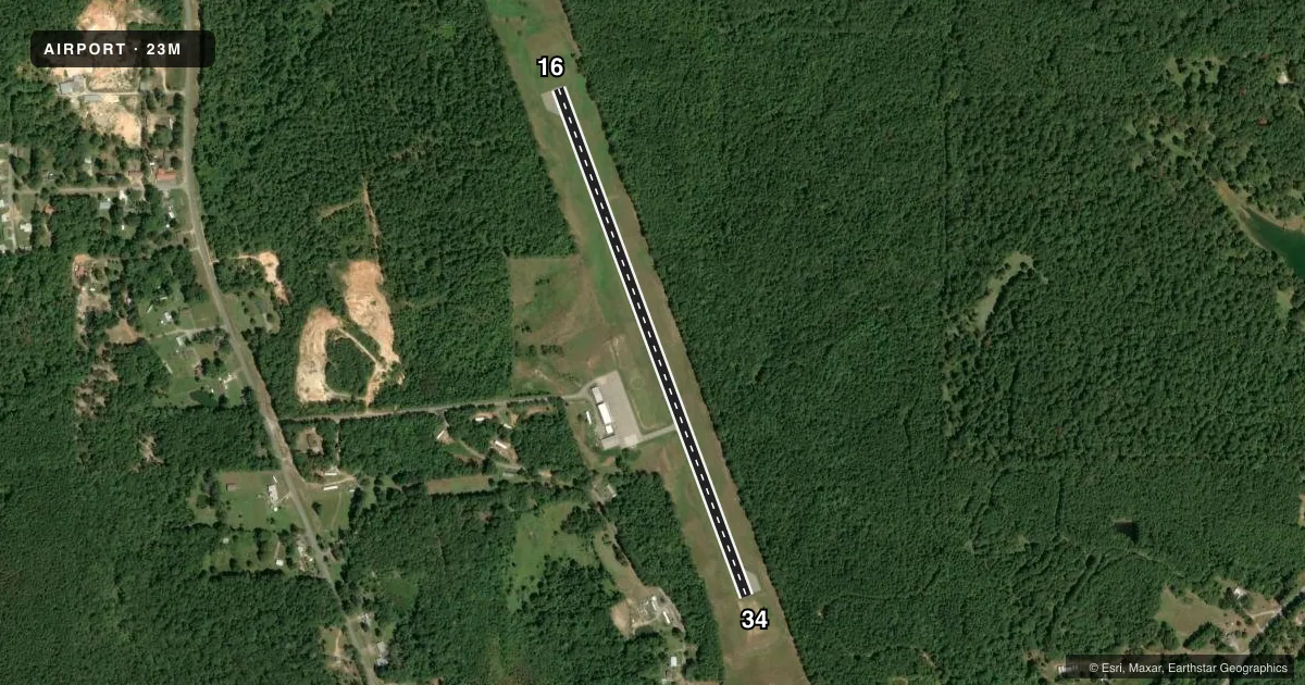
Runways & pattern
Full pagePattern entry · RWY 16
LEFT TRAFFICRunway end performance
| End | TORA | TODA | ASDA | LDA | VGSI | Approach lights | Obstruction |
|---|---|---|---|---|---|---|---|
| 16 | — | — | — | — | PAPI 2-box left(4°) | — | 47', trees, 1215' from thr, 0' R of cntrln, slope 21 |
| 34 | — | — | — | — | — | — | 51', trees, 1250' from thr, slope 20 |
Declared distances in feet. TORA = takeoff run available, TODA = takeoff distance, ASDA = accelerate-stop, LDA = landing distance.
Airport sketch
Runways drawn to scale from FAA survey coordinates, rendered over satellite imagery. Not for navigation.
Approaches & charts
Services on the field
Fuel grades, oxygen, maintenance, ramp storage and lighting — as declared to the FAA by the airport operator.
Fuel & services
- Fuel
- 100LL
- Oxygen (bottled)
- Not available
- Oxygen (bulk)
- Not available
- Airframe repair
- Not available
- Power plant repair
- Not available
- Other services
- AGRI
Ramp & ground
- Transient storage
- Tie-down
- Landing fee
- No fee published
- Customs
- Not available
- Lighting schedule
- SEE RMK
- Beacon schedule
- SS-SR
- Beacon
- White / Green (civil land)(WG)
- Wind indicator
- Lighted
- Segmented circle
- Yes
Fuel & FBOs
Cheapest 100LL and Jet A on the field and nearby. Always confirm with the FBO before taxi.
Airport notes
Surface conditions, obstructions, local procedures, lighting outages and other notes published with each FAA cycle.
General notes
- GND DROPS ABRUPTLY 240 FT FM RWY 34 THR.
- GND DROPS ABRUPTLY 250 FT FM RWY 16 THR.
- ULTRALIGHT ACTVTY ON & INVOF ARPT.
- FOR CD CTC MERIDIAN APCH 601-679-3691, WHEN MERIDIAN APCH CLSD CTC MEMPHIS ARTCC AT 901-368-8453/8449.
Lighting notes
- LGTS OPR DUSK-2200. AFT 2200 ACTVT MIRL RWY 16/34 - CTAF.
Fuel notes
- 100LL24 HR SELF SVC FUEL AVBL WITH CREDIT CARD.
Other notes
- PILOTS MUST PRVD THEIR OWN TIEDOWN ROPES.
VFR map & nearby airports
VFR sectional. Tap any ICAO chip to open that airport.
Key facts · 23M
Answer card- ICAO
- 23M
- Name
- CLARKE COUNTY
- Location
- QUITMAN, MISSISSIPPI
- Elevation
- 321.3 ft MSL
- Traffic pattern altitude
- 1,321.3 ft MSL (1,000 AGL)
- Control tower
- Non-towered (use CTAF)
- Total runways
- 1
- Longest runway
- 16/34 · 3,295 ft
- Published ILS approaches
- 0
- Published frequencies
- 2
- Magnetic variation
- 2°
- Current flight rules
- VFR
- Current wind
- 000° at 0 kt
- Favored runway now
- –
Clarke County Airport (23M) sits in Quitman, Mississippi. Field elevation is 321.3 ft MSL. The airport has one runway. Runway 16/34 is 3,295 ft long and asphalt. This is a non-towered field. CTAF and UNICOM are both 122.8. No ILS approaches are published here.
Pattern altitude is not published. Use the standard 1,000 ft AGL pattern unless the current Chart Supplement says otherwise. The on-field FBO is Clarke County Airport. It carries 100LL and MOGAS. Self-serve fuel is available with credit card. Pilots must provide their own tiedown ropes.
There are a few operational items to plan for. The ground drops abruptly 250 feet from the runway 16 threshold. The ground also drops abruptly 240 feet from the runway 34 threshold. Ultralight activity occurs on and near the airport. Lights operate from dusk to 2200. After 2200, medium intensity runway lights on 16/34 are activated using CTAF. For clearance delivery, contact Meridian Approach at 601-679-3691. When Meridian Approach is closed, contact Memphis ARTCC at 901-368-8453 or 901-368-8449. If you are new to the field, brief the runway length, the slope near both thresholds. Brief the mixed traffic picture before you arrive.