METAR & TAF 09A
09A does not publish a METAR.
Showing the nearest reporting station: KDYA (DEMOPOLIS RGNL) · 22.5 NM away. Conditions at 09A may differ.
METAR · KDYA
Observed 08:35Z
KDYA 270835Z AUTO 00000KT 5SM HZ CLR A2993 RMK AO2
- Wind
- 000° @ 0 kt
- Visibility
- 5 SM
- Temp / Dew
- —
- Altimeter
- 29.93 inHg
- Clouds
- CLR
- Density alt
- —
- Ceiling
- Unlimited
- Rules
- MVFR
Airport info & contacts
Manager on record, flight service, ARTCC, attendance schedule and pattern altitude — published by the FAA and refreshed every 28 days.
Location
- From city
- 5 NM NE
- VFR sectional
- MEMPHIS
- ARTCC
- ZME · MEMPHIS
- NOTAM facility
- ANB (NOTAM-D)
Airport manager
- Name
- TYLER DAVIDSON
- Phone
- (205) 459-2153
- Address
- 117 SOUTH MULBERRY, SUITE 12, BUTLER AL 36904
Flight service · Hours
- FSS ANB
- ANNISTON1-800-WX-BRIEF
- Attendance
- Unattended
Frequencies
Tap any row to copy the frequency to your clipboard.
Runways & pattern
Full pagePattern entry · RWY 12
LEFT TRAFFICRunway end performance
| End | TORA | TODA | ASDA | LDA | VGSI | Approach lights | Obstruction |
|---|---|---|---|---|---|---|---|
| 12 | — | — | — | — | PAPI 2-box left(3°) | — | 28', tree, 217' from thr, 127' R of cntrln, slope 0 |
| 30 | — | — | — | — | PAPI 2-box left(3°) | — | — |
Declared distances in feet. TORA = takeoff run available, TODA = takeoff distance, ASDA = accelerate-stop, LDA = landing distance.
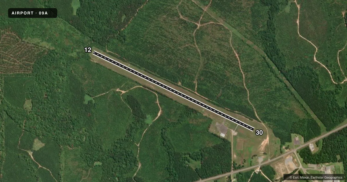
Airport sketch
Runways drawn to scale from FAA survey coordinates, rendered over satellite imagery. Not for navigation.
Approaches & charts
Services on the field
Fuel grades, oxygen, maintenance, ramp storage and lighting — as declared to the FAA by the airport operator.
Fuel & services
- Fuel
- Not available
- Oxygen (bottled)
- Not available
- Oxygen (bulk)
- Not available
- Airframe repair
- Not available
- Power plant repair
- Not available
Ramp & ground
- Transient storage
- Tie-down
- Landing fee
- No fee published
- Customs
- Not available
- Lighting schedule
- SEE RMK
- Beacon schedule
- SS-SR
- Beacon
- White / Green (civil land)(WG)
- Wind indicator
- Lighted
- Segmented circle
- Yes
Fuel & FBOs
Cheapest 100LL and Jet A on the field and nearby. Always confirm with the FBO before taxi.
Airport notes
Surface conditions, obstructions, local procedures, lighting outages and other notes published with each FAA cycle.
General notes
- FOR CD CTC MERIDIAN APCH 601-679-3691, WHEN MERIDIAN APCH CLSD CTC ATLANTA ARTCC AT 770-210-7692.
Lighting notes
- ACTVT PAPI RWY 30; MIRL RWY 12/30 - CTAF.
Approach & departure obstructions
- 12TREES LCTD 31 FT FROM PAVEMENT END BEGINNING AT 125 FT RIGHT OF CL AND CONTG ACRS TO 125 FT LEFT OF CL. 8:1 SLOPE FROM DSPLCD THR.
- 12MARKINGS COMPLETELY FADED
- 30MARKINGS COMPLETELY FADED.
- 12PAPI UNUSBL BYD 8 DEGS LEFT OF CNTRLN.
- 30PAPI RWY 30 OTS INDEFLY.
- 12CONTROLLING OBSTN EXCEEDS A 45 DEG SLP
Other notes
- 12/30RWY POOR COND DUE TO EXTSV CRACKING WITH VEGETATION AND RAVELING.
VFR map & nearby airports
VFR sectional. Tap any ICAO chip to open that airport.
Key facts · 09A
Answer card- ICAO
- 09A
- Name
- BUTLER/CHOCTAW COUNTY
- Location
- BUTLER, ALABAMA
- Elevation
- 133.7 ft MSL
- Traffic pattern altitude
- 1,133.7 ft MSL (1,000 AGL)
- Control tower
- Non-towered (use CTAF)
- Total runways
- 1
- Longest runway
- 12/30 · 4,082 ft
- Published ILS approaches
- 0
- Published frequencies
- 4
- Magnetic variation
- 3°
- Current flight rules
- MVFR
- Current wind
- 000° at 0 kt
- Favored runway now
- –
Butler/Choctaw County Airport sits in Butler, Alabama. Field elevation is 133.7 ft MSL. It has one runway. Runway 12/30 is 4,082 ft long with asphalt pavement. The airport is non-towered. CTAF and UNICOM are both 122.8. Meridian Approach handles clearance delivery and approach or departure support on 121.275 and 348.7. No ILS approaches are published here.
Pattern altitude is not published. Use 1,000 ft AGL for light piston traffic unless the current Chart Supplement says otherwise. For runway 12, published remarks say the PAPI is unusable beyond 8 degrees left of centerline. Runway 12 also has trees close to the departure end. The controlling obstruction exceeds a 45 degree slope. Runway 12 markings are completely faded. Runway 30 markings are also completely faded. The runway is in poor condition due to extensive cracking with vegetation and raveling.
There are no on-field FBOs listed in the facts. Contact the airport operator directly before arrival, or call the field on CTAF or UNICOM for current FBO availability. If you need clearance delivery, Meridian Approach is the published contact. When Meridian Approach is closed, Atlanta ARTCC is the backup contact. This is a small non-towered field with a short runway and degraded markings. A careful stabilized approach matters here.