METAR & TAF 7A0
7A0 does not publish a METAR.
Showing the nearest reporting station: KDYA (DEMOPOLIS RGNL) · 19.7 NM away. Conditions at 7A0 may differ.
METAR · KDYA
Observed 11:35Z
KDYA 271135Z AUTO 00000KT 2 1/2SM BR SCT060 A2996 RMK AO2
- Wind
- 000° @ 0 kt
- Visibility
- 0.5 SM
- Temp / Dew
- —
- Altimeter
- 29.96 inHg
- Clouds
- SCT
- Density alt
- —
- Ceiling
- Unlimited
- Rules
- LIFR
Airport info & contacts
Manager on record, flight service, ARTCC, attendance schedule and pattern altitude — published by the FAA and refreshed every 28 days.
Location
- From city
- 3 NM SW
- VFR sectional
- ATLANTA
- ARTCC
- ZTL · ATLANTA
- NOTAM facility
- ANB (NOTAM-D)
Airport manager
- Name
- CHARLES SEALE
- Phone
- 334-624-9871
- Address
- PO BOX 437, GREENSBORO AL 36744
Flight service · Hours
- FSS ANB
- ANNISTON1-800-WX-BRIEF
- Attendance
- UNATTND
Frequencies
Tap any row to copy the frequency to your clipboard.
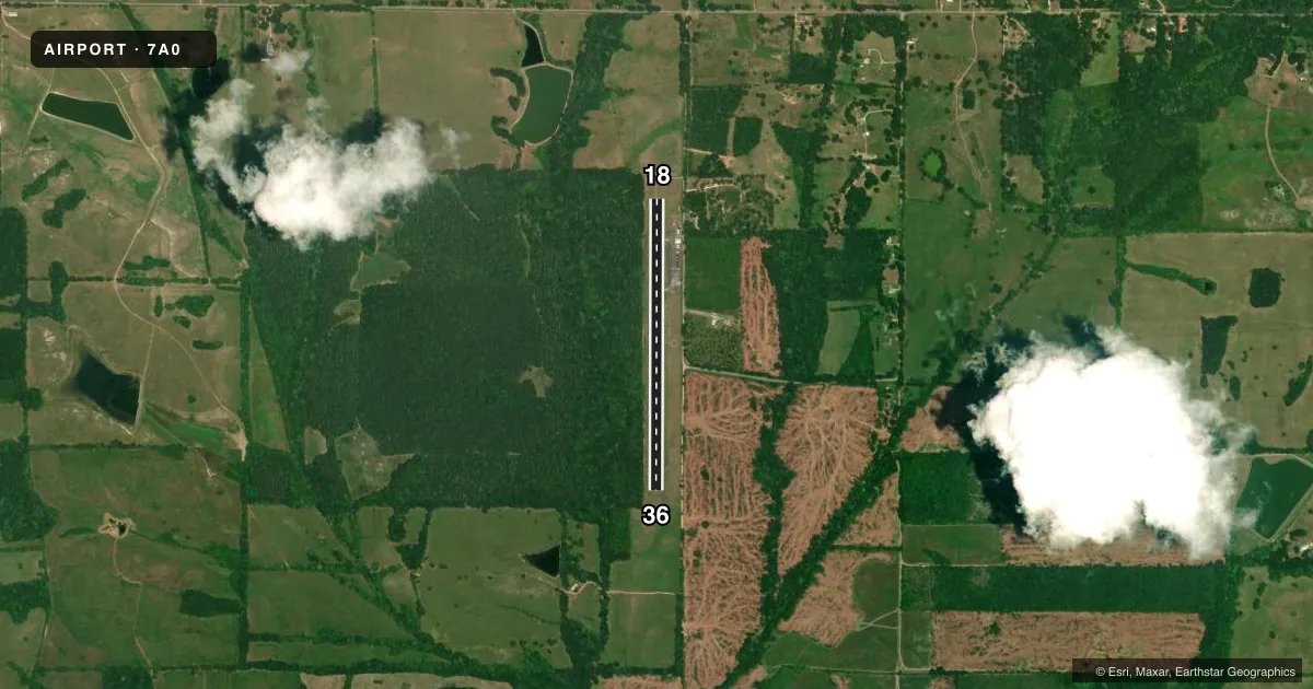
Runways & pattern
Full pagePattern entry · RWY 18
LEFT TRAFFICAirport sketch
Runways drawn to scale from FAA survey coordinates, rendered over satellite imagery. Not for navigation.
Approaches & charts
Services on the field
Fuel grades, oxygen, maintenance, ramp storage and lighting — as declared to the FAA by the airport operator.
Fuel & services
- Fuel
- 100LL
- Oxygen (bottled)
- Not available
- Oxygen (bulk)
- Not available
- Airframe repair
- Not available
- Power plant repair
- Not available
- Other services
- INSTR
Ramp & ground
- Transient storage
- Tie-down
- Landing fee
- No fee published
- Customs
- Not available
- Lighting schedule
- SEE RMK
- Wind indicator
- Lighted
- Segmented circle
- Yes
Fuel & FBOs
Cheapest 100LL and Jet A on the field and nearby. Always confirm with the FBO before taxi.
Airport notes
Surface conditions, obstructions, local procedures, lighting outages and other notes published with each FAA cycle.
General notes
- FOR CD CTC ATLANTA ARTCC AT 770-210-7692.
Lighting notes
- OTS INDEFLY.
- ACTVT REIL RWY 18 & 36; MIRL RWY 18/36 - CTAF.
VFR map & nearby airports
VFR sectional. Tap any ICAO chip to open that airport.
Key facts · 7A0
Answer card- ICAO
- 7A0
- Name
- GREENSBORO MUNI
- Location
- GREENSBORO, ALABAMA
- Elevation
- 175.1 ft MSL
- Traffic pattern altitude
- 1,175.1 ft MSL (1,000 AGL)
- Control tower
- Non-towered (use CTAF)
- Total runways
- 1
- Longest runway
- 18/36 · 3,506 ft
- Published ILS approaches
- 0
- Published frequencies
- 2
- Magnetic variation
- 1°
- Current flight rules
- LIFR
- Current wind
- 000° at 0 kt
- Favored runway now
- –
Greensboro Muni is in Greensboro, Alabama. The field elevation is 175.1 ft MSL. It has one runway. The longest is 18/36 at 3,506 ft on asphalt. This is an untowered field. Self-announce on CTAF 123.0. The published pattern altitude is not listed. Use the standard 1,000 ft AGL pattern for light piston traffic unless local procedures or the current Chart Supplement say otherwise.
No ILS approaches are published here. That matters if you are planning a low-visibility arrival. Check the current Chart Supplement for the latest instrument options before you go. The published remarks also note that clearance delivery is handled through Atlanta ARTCC at 770-210-7692. Runway end identifier lights are published on 18 and 36. Medium intensity runway lights are also activated on 18 and 36 by CTAF.
There are no on-field FBOs listed in the facts. FBO options vary. Contact the airport operator directly before arrival, or call the field on CTAF/UNICOM for current FBO availability. The remarks also show the airport as out of service indefinitely, so verify the current status with the airport operator before planning a trip. For a first-time arrival, treat this as a small non-towered Alabama field with one short asphalt runway, no published ILS and lighting that depends on CTAF activation.