METAR & TAF KAIV
KAIV does not publish a METAR.
Showing the nearest reporting station: KGTR (GOLDEN TRIANGLE RGNL) · 28.5 NM away. Conditions at KAIV may differ.
METAR · KGTR
Observed 07:56Z
KGTR 270756Z AUTO 00000KT 10SM BKN050 27/26 A2994 RMK AO2 SLP136 T02670256 $
- Wind
- 000° @ 0 kt
- Visibility
- 10 SM
- Temp / Dew
- 27°C / 26°C
- Altimeter
- 29.94 inHg
- Clouds
- BKN
- Density alt
- 1,601 ft
- Ceiling
- 5,000 ft AGL
- Rules
- VFR
Airport info & contacts
Manager on record, flight service, ARTCC, attendance schedule and pattern altitude — published by the FAA and refreshed every 28 days.
Location
- From city
- 2 NM SW
- VFR sectional
- MEMPHIS
- ARTCC
- ZME · MEMPHIS
- NOTAM facility
- ANB (NOTAM-D)
Airport manager
- Name
- LARRY POTTS
- Phone
- 205-373-0446
- Address
- 11135 HWY 17, ALICEVILLE AL 35442
Flight service · Hours
- FSS ANB
- ANNISTON1-800-WX-BRIEF
- Attendance
- Unattended
Frequencies
Tap any row to copy the frequency to your clipboard.
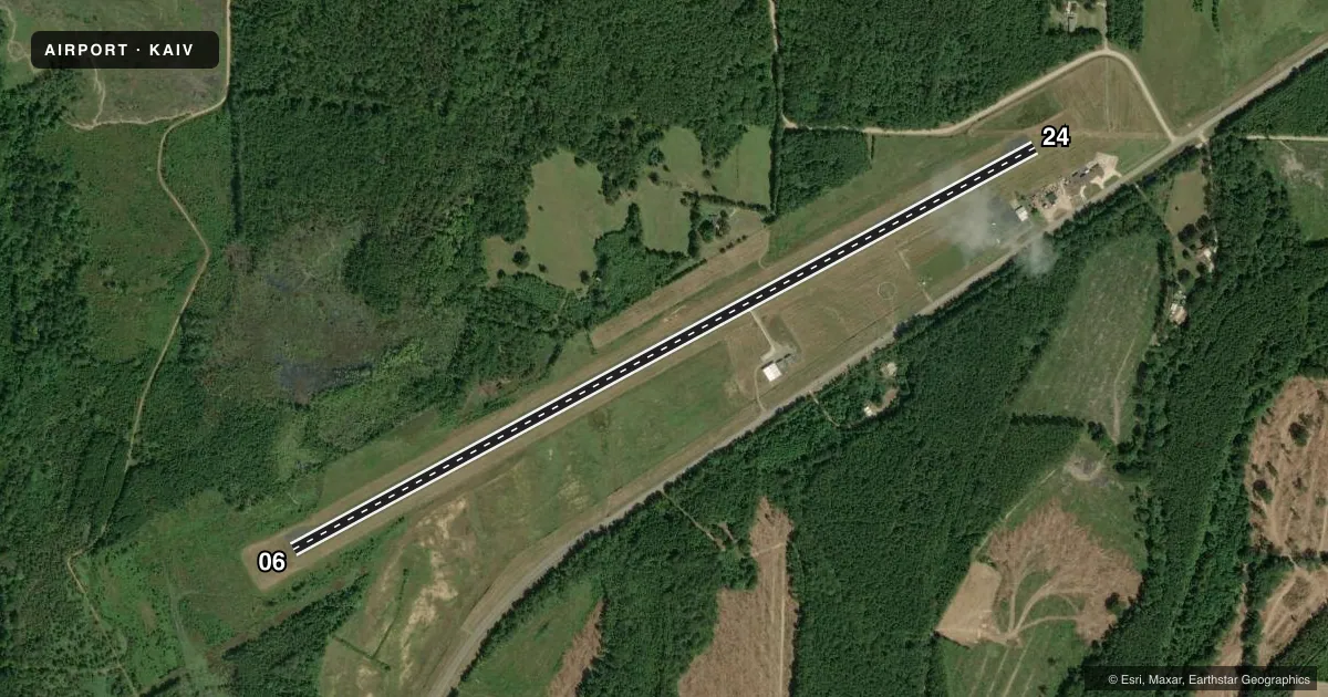
Runways & pattern
Full pagePattern entry · RWY 06
LEFT TRAFFICRunway end performance
| End | TORA | TODA | ASDA | LDA | VGSI | Approach lights | Obstruction |
|---|---|---|---|---|---|---|---|
| 06 | — | — | — | — | — | — | 22', tree, 640' from thr, 114' R of cntrln, slope 20 |
| 24 | — | — | — | — | — | — | 81', tree, 1983' from thr, 73' R of cntrln, slope 22 |
Declared distances in feet. TORA = takeoff run available, TODA = takeoff distance, ASDA = accelerate-stop, LDA = landing distance.
Airport sketch
Runways drawn to scale from FAA survey coordinates, rendered over satellite imagery. Not for navigation.
Approaches & charts
Services on the field
Fuel grades, oxygen, maintenance, ramp storage and lighting — as declared to the FAA by the airport operator.
Fuel & services
- Fuel
- 100LL
- Oxygen (bottled)
- Not available
- Oxygen (bulk)
- Not available
- Airframe repair
- Not available
- Power plant repair
- Not available
Ramp & ground
- Transient storage
- Tie-down
- Landing fee
- No fee published
- Lighting schedule
- SEE RMK
- Beacon schedule
- SS-SR
- Beacon
- White / Green (civil land)(WG)
- Wind indicator
- Lighted
- Segmented circle
- Yes
Fuel & FBOs
Cheapest 100LL and Jet A on the field and nearby. Always confirm with the FBO before taxi.
Airport notes
Surface conditions, obstructions, local procedures, lighting outages and other notes published with each FAA cycle.
General notes
- TWY LGTS FOR TWY TURNOFF ONLY.
- FOR CD CTC COLUMBUS APCH AT 662-434-3044.
Lighting notes
- ACTVT REILS RWY 06 & 24; MIRL RWY 06/24 - CTAF.
Approach & departure obstructions
- 06RWY 6 MKINGS SVRLY FADED
- 24RWY 24 MKINGS SVRLY FADED
Other notes
- BEFORE FAA ACT.
- OWNERALTN FONE NR 205-399-1423.
VFR map & nearby airports
VFR sectional. Tap any ICAO chip to open that airport.
Key facts · KAIV
Answer card- ICAO
- KAIV
- Name
- GEORGE DOWNER
- Location
- ALICEVILLE, ALABAMA
- Elevation
- 150 ft MSL
- Traffic pattern altitude
- 1,150 ft MSL (1,000 AGL)
- Control tower
- Non-towered (use CTAF)
- Total runways
- 1
- Longest runway
- 06/24 · 5,001 ft
- Published ILS approaches
- 0
- Published frequencies
- 4
- Magnetic variation
- 2°
- Current flight rules
- VFR
- Current wind
- 000° at 0 kt
- Favored runway now
- –
George Downer Airport sits in Aliceville, Alabama. Field elevation is 150 ft MSL. It has one runway, 06/24, which is 5,001 ft long. There is no control tower. CTAF and UNICOM are both 122.8. No ILS approaches are published here.
Pattern altitude is not published. Use 1,000 ft AGL for light piston operations unless the current Chart Supplement says otherwise. The runway is asphalt. Magnetic runway headings are 06 and 24, with published headings of 62° and 242° magnetic. Runway end identifier lights are active on both ends. Medium intensity runway lights are on 06/24 and are controlled by CTAF.
Published remarks matter here. Taxiway lights are for taxiway turnoff only. Runway 6 markings are severely faded. Runway 24 markings are severely faded. For clearance delivery, contact Columbus Approach at 662-434-3044. No on-field FBOs are listed, so verify fuel and services with the airport operator or the FBO directly by phone before you go. First-time visitors should plan for a non-towered arrival and pay close attention to the faded runway markings on rollout and taxi.