METAR & TAF KUBS
KUBS does not publish a METAR.
Showing the nearest reporting station: KGTR (GOLDEN TRIANGLE RGNL) · 10.6 NM away. Conditions at KUBS may differ.
METAR · KGTR
Observed 12:56Z
KGTR 271256Z 35004KT 10SM SCT028 BKN060 BKN085 27/25 A3001 RMK AO2 SLP160 T02720250 $
- Wind
- 350° @ 4 kt
- Visibility
- 10 SM
- Temp / Dew
- 27°C / 25°C
- Altimeter
- 30.01 inHg
- Clouds
- BKN
- Density alt
- 1,562 ft
- Ceiling
- 6,000 ft AGL
- Rules
- VFR
Airport info & contacts
Manager on record, flight service, ARTCC, attendance schedule and pattern altitude — published by the FAA and refreshed every 28 days.
Location
- From city
- 3 NM SE
- VFR sectional
- MEMPHIS
- ARTCC
- ZME · MEMPHIS
- NOTAM facility
- GWO (NOTAM-D)
Airport manager
- Name
- DAN DUSTON
- Phone
- 662-251-4650
- Address
- 368 FABRITEK DR, COLUMBUS MS 39702
Flight service · Hours
- FSS GWO
- GREENWOOD1-800-WX-BRIEF
- Attendance
- MON-FRI · 0800-1800
- SAT-SUN · ON CALL
Frequencies
Tap any row to copy the frequency to your clipboard.
Runways & pattern
Full pagePattern entry · RWY 36
LEFT TRAFFICRunway end performance
| End | TORA | TODA | ASDA | LDA | VGSI | Approach lights | Obstruction |
|---|---|---|---|---|---|---|---|
| 18 | — | — | — | — | PAPI 2-box left(3°) | — | 68', trees, 2510' from thr, 300' R of cntrln, slope 34 |
| 36 | — | — | — | — | PAPI 2-box left(3°) | — | 67', trees, 2075' from thr, 0' R of cntrln, slope 27 |
Declared distances in feet. TORA = takeoff run available, TODA = takeoff distance, ASDA = accelerate-stop, LDA = landing distance.
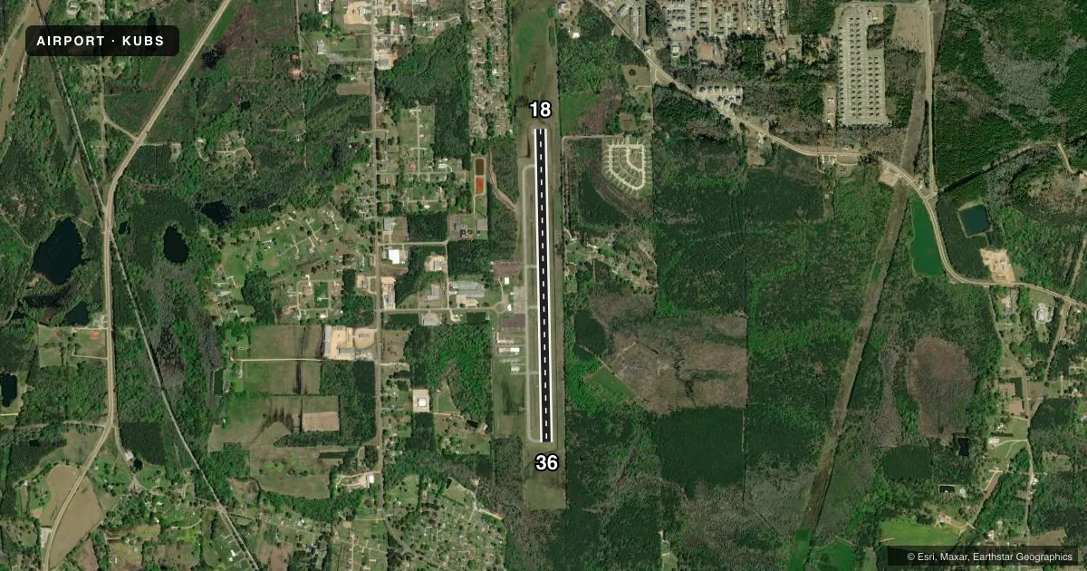
Airport sketch
Runways drawn to scale from FAA survey coordinates, rendered over satellite imagery. Not for navigation.
Approaches & charts
Services on the field
Fuel grades, oxygen, maintenance, ramp storage and lighting — as declared to the FAA by the airport operator.
Fuel & services
- Fuel
- 100LLA+
- Oxygen (bottled)
- Not available
- Oxygen (bulk)
- Not available
- Airframe repair
- Minor
- Power plant repair
- Minor
- Other services
- AMB,INSTR
Ramp & ground
- Transient storage
- Tie-down
- Hangar
- Landing fee
- No fee published
- Customs
- Not available
- Lighting schedule
- SEE RMK
- Beacon schedule
- SS-SR
- Beacon
- White / Green (civil land)(WG)
- Wind indicator
- Lighted
- Segmented circle
- Yes
Fuel & FBOs
Cheapest 100LL and Jet A on the field and nearby. Always confirm with the FBO before taxi.
Airport notes
Surface conditions, obstructions, local procedures, lighting outages and other notes published with each FAA cycle.
General notes
- FOR CD CTC MEMPHIS ARTCC AT 901-368-8453/8449.
- COURTESY CAR AVBL.
Lighting notes
- MIRL RWY 18/36 OPR DUSK - 2200; AFT 2200 ACTVT - CTAF. PAPI RWY 18 & 36 OPR CONSLY.
Fuel notes
- 100LLFUEL AVBL 24 HRS WITH CREDIT CARD.
Approach & departure obstructions
- 36OTS UFN.
Other notes
- CALL AHEAD FOR HNGR SPACE.
VFR map & nearby airports
VFR sectional. Tap any ICAO chip to open that airport.
Key facts · KUBS
Answer card- ICAO
- KUBS
- Name
- COLUMBUS-LOWNDES COUNTY
- Location
- COLUMBUS, MISSISSIPPI
- Elevation
- 188.1 ft MSL
- Traffic pattern altitude
- 1,188.1 ft MSL (1,000 AGL)
- Control tower
- Non-towered (use CTAF)
- Total runways
- 1
- Longest runway
- 18/36 · 4,503 ft
- Published ILS approaches
- 0
- Published frequencies
- 4
- Magnetic variation
- 3°
- Current flight rules
- VFR
- Current wind
- 350° at 4 kt
- Favored runway now
- RWY 36
Columbus-Lowndes County Airport sits in Columbus, Mississippi. Field elevation is 188.1 ft MSL. It has one runway, 18/36, which is 4,503 ft long. The airport is not towered. For clearance delivery, contact Memphis ARTCC. The published traffic pattern altitude is not listed, so use the standard 1,000 ft AGL for light piston traffic unless the current Chart Supplement says otherwise.
No ILS approaches are published here. That matters if you are planning an IFR arrival in lower weather. Runway 36 has omni-directional touchdown zone lighting out of service until further notice. Medium intensity runway lights on 18/36 operate from dusk to 2200. After 2200, lighting activation is on CTAF. The PAPI on both runway ends operates continuously.
The on-field FBO is Columbus-Lowndes County Airport. It carries AVGAS 100LL and JET A. Fuel is available 24 hours with credit card. A courtesy car is available. Call ahead for hangar space. The field is a practical stop for local and transient traffic. Plan your arrival with the published lighting notes in mind, especially if you expect a late arrival or night departure.