METAR & TAF 4R3
4R3 does not publish a METAR.
Showing the nearest reporting station: KGZH (EVERGREEN RGNL/MIDDLETON FLD) · 43.8 NM away. Conditions at 4R3 may differ.
METAR · KGZH
Observed 12:53Z
KGZH 271253Z AUTO 00000KT 10SM CLR 28/24 A2997 RMK AO2 SLP144 T02780244
- Wind
- 000° @ 0 kt
- Visibility
- 10 SM
- Temp / Dew
- 28°C / 24°C
- Altimeter
- 29.97 inHg
- Clouds
- CLR
- Density alt
- 1,575 ft
- Ceiling
- Unlimited
- Rules
- VFR
Airport info & contacts
Manager on record, flight service, ARTCC, attendance schedule and pattern altitude — published by the FAA and refreshed every 28 days.
Location
- From city
- 2 NM S
- VFR sectional
- NEW ORLEANS
- ARTCC
- ZHU · HOUSTON
- NOTAM facility
- ANB (NOTAM-D)
Airport manager
- Name
- KEVIN WOODSON
- Phone
- 251-231-0511
- Address
- PO BOX 1096, JACKSON AL 36546
Flight service · Hours
- FSS ANB
- ANNISTON1-800-WX-BRIEF
- Attendance
- Unattended
Frequencies
Tap any row to copy the frequency to your clipboard.
Runways & pattern
Full pagePattern entry · RWY 01
LEFT TRAFFICRunway end performance
| End | TORA | TODA | ASDA | LDA | VGSI | Approach lights | Obstruction |
|---|---|---|---|---|---|---|---|
| 01 | — | — | — | — | PAPI 2-box left(3°) | — | 23', tree, 657' from thr, 150' R of cntrln, slope 19 |
| 19 | — | — | — | — | PAPI 2-box left(3°) | — | 18', tree, 519' from thr, 75' R of cntrln, slope 17 |
Declared distances in feet. TORA = takeoff run available, TODA = takeoff distance, ASDA = accelerate-stop, LDA = landing distance.
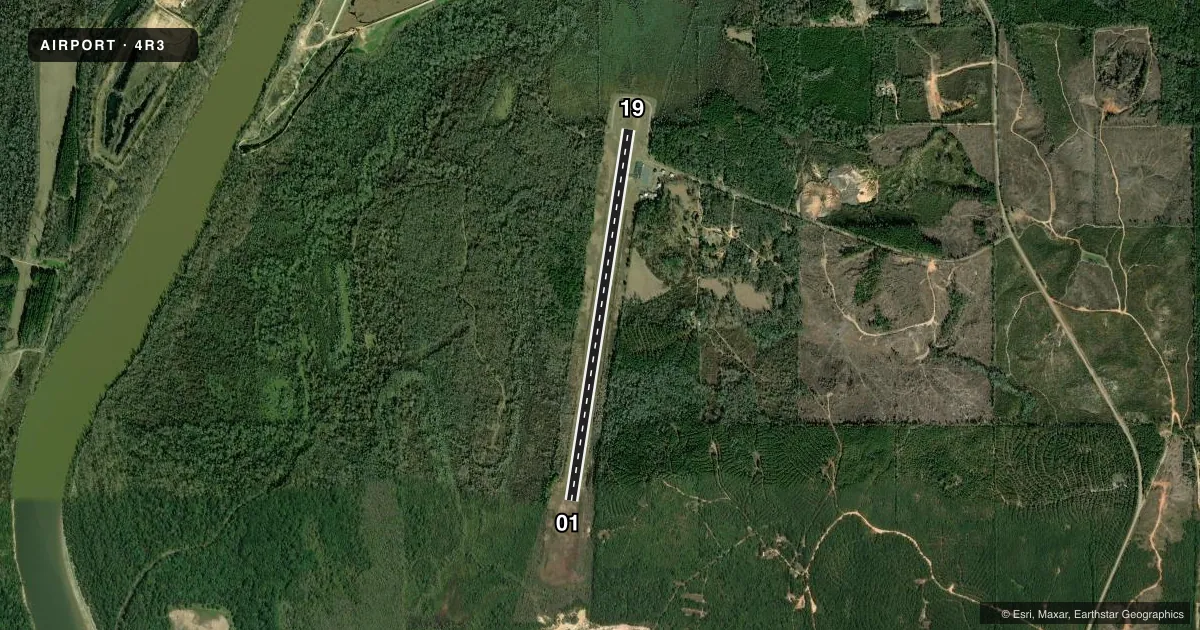
Airport sketch
Runways drawn to scale from FAA survey coordinates, rendered over satellite imagery. Not for navigation.
Approaches & charts
Services on the field
Fuel grades, oxygen, maintenance, ramp storage and lighting — as declared to the FAA by the airport operator.
Fuel & services
- Fuel
- 100LL
- Oxygen (bottled)
- Not available
- Oxygen (bulk)
- Not available
- Airframe repair
- Not available
- Power plant repair
- Not available
Ramp & ground
- Transient storage
- Tie-down
- Landing fee
- No fee published
- Customs
- Not available
- Lighting schedule
- SEE RMK
- Beacon schedule
- SS-SR
- Beacon
- White / Green (civil land)(WG)
- Wind indicator
- Lighted
- Segmented circle
- No
Fuel & FBOs
Cheapest 100LL and Jet A on the field and nearby. Always confirm with the FBO before taxi.
Airport notes
Surface conditions, obstructions, local procedures, lighting outages and other notes published with each FAA cycle.
General notes
- RWY 01/19 SLPS UPHILL TO THE SOUTH.
- FOR CD CTC HOUSTON ARTCC AT 281-230-5622.
Lighting notes
- ACTVT PAPI RWY 01 & 19; MIRL RWY 01/19 - CTAF.
Fuel notes
- 100LLFUEL 24 HR CREDIT CARD SVC AVBL.
VFR map & nearby airports
VFR sectional. Tap any ICAO chip to open that airport.
Key facts · 4R3
Answer card- ICAO
- 4R3
- Name
- JACKSON MUNI
- Location
- JACKSON, ALABAMA
- Elevation
- 62.4 ft MSL
- Traffic pattern altitude
- 1,062.4 ft MSL (1,000 AGL)
- Control tower
- Non-towered (use CTAF)
- Total runways
- 1
- Longest runway
- 01/19 · 5,003 ft
- Published ILS approaches
- 0
- Published frequencies
- 1
- Magnetic variation
- 2°
- Current flight rules
- VFR
- Current wind
- 000° at 0 kt
- Favored runway now
- –
Jackson Muni is in Jackson, Alabama. The field elevation is 62.4 ft MSL. It has one runway, 01/19, which is 5,003 ft long and paved with asphalt. There is no control tower. CTAF is 122.9. No ILS approaches are published here, so plan to use non-precision or visual procedures as available on the current charting.
The published pattern altitude is not listed. For light piston operations, use the standard 1,000 ft AGL unless the current Chart Supplement says otherwise. The on-field FBO is Jackson Municipal Airport. It carries 100LL. Fuel is available 24 hours with credit card service. Runway 01/19 has PAPI on both ends. Medium intensity runway lights are also on 01 and 19. They are controlled by CTAF. The runway slopes uphill to the south, so expect the 19 end to feel different on rollout and takeoff.
For departure planning, clearance delivery is handled through Houston ARTCC at 281-230-5622. That matters if you need a clearance before taxi. This is a small non-towered field, so listen carefully on CTAF and verify current airport details in the FAA Chart Supplement before you go. The published remarks also point to the uphill runway profile, which is worth keeping in mind if you are operating at higher weight or in hot weather.