METAR & TAF 2R0
2R0 does not publish a METAR.
Showing the nearest reporting station: KLUL (HESLER/NOBLE FLD) · 27.5 NM away. Conditions at 2R0 may differ.
METAR · KLUL
Observed 16:15Z
KLUL 271615Z AUTO 28008KT 10SM SCT055 SCT070 BKN080 33/24 A2998 RMK A02 T03320236
- Wind
- 280° @ 8 kt
- Visibility
- 10 SM
- Temp / Dew
- 33°C / 24°C
- Altimeter
- 29.98 inHg
- Clouds
- BKN
- Density alt
- 2,295 ft
- Ceiling
- 8,000 ft AGL
- Rules
- VFR
Airport info & contacts
Manager on record, flight service, ARTCC, attendance schedule and pattern altitude — published by the FAA and refreshed every 28 days.
Location
- From city
- 2 NM S
- VFR sectional
- NEW ORLEANS
- ARTCC
- ZME · MEMPHIS
- NOTAM facility
- GWO (NOTAM-D)
Airport manager
- Name
- RANDY PITTS
- Phone
- 601-735-9682
- Address
- 714 WAYNE ST, WAYNESBORO MS 39367
Flight service · Hours
- FSS GWO
- GREENWOOD1-800-WX-BRIEF
- Attendance
- M-F · 0600-1400
Frequencies
Tap any row to copy the frequency to your clipboard.
Runways & pattern
Full pagePattern entry · RWY 20
LEFT TRAFFICRunway end performance
| End | TORA | TODA | ASDA | LDA | VGSI | Approach lights | Obstruction |
|---|---|---|---|---|---|---|---|
| 02 | — | — | — | — | PAPI 2-box left | — | 73', trees, 1700' from thr, 100' R of cntrln, slope 20 |
| 20 | — | — | — | — | PAPI 2-box left | — | 23', rr, 600' from thr, 0' R of cntrln, slope 17 |
Declared distances in feet. TORA = takeoff run available, TODA = takeoff distance, ASDA = accelerate-stop, LDA = landing distance.
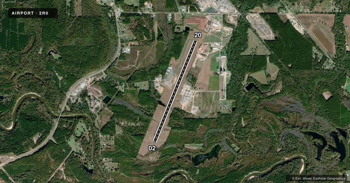
Airport sketch
Runways drawn to scale from FAA survey coordinates, rendered over satellite imagery. Not for navigation.
Approaches & charts
Services on the field
Fuel grades, oxygen, maintenance, ramp storage and lighting — as declared to the FAA by the airport operator.
Fuel & services
- Fuel
- 100LLA1+
- Oxygen (bottled)
- Not available
- Oxygen (bulk)
- Not available
- Other services
- AGRI
Ramp & ground
- Transient storage
- Tie-down
- Landing fee
- No fee published
- Customs
- Not available
- Lighting schedule
- SEE RMK
- Beacon schedule
- SS-SR
- Beacon
- White / Green (civil land)(WG)
- Wind indicator
- Lighted
- Segmented circle
- Yes
Fuel & FBOs
Cheapest 100LL and Jet A on the field and nearby. Always confirm with the FBO before taxi.
Airport notes
Surface conditions, obstructions, local procedures, lighting outages and other notes published with each FAA cycle.
General notes
- FOR CD CTC MEMPHIS ARTCC AT 901-368-8453/8449.
- WILDLIFE NR RWY 20.
Lighting notes
- ACTVT PAPI RWY 02 & 20; MIRL RWY 02/20 - CTAF.
Fuel notes
- 100LL24 HR CREDIT CARD SVC AVBL.
Approach & departure obstructions
- 20APCH RATIO 50+:1 TO DTHR.
Other notes
- AVBL UPON REQ; 410-404-8959.
- AVBL UPON REQ; 410-404-8959.
- PILOT MUST PRVD TIEDOWN ROPES.
- 1AFT HRS SVC CTC AMGR 410-404-8959.
VFR map & nearby airports
VFR sectional. Tap any ICAO chip to open that airport.
Key facts · 2R0
Answer card- ICAO
- 2R0
- Name
- WAYNESBORO MUNI
- Location
- WAYNESBORO, MISSISSIPPI
- Elevation
- 168.5 ft MSL
- Traffic pattern altitude
- 1,168.5 ft MSL (1,000 AGL)
- Control tower
- Non-towered (use CTAF)
- Total runways
- 1
- Longest runway
- 02/20 · 5,000 ft
- Published ILS approaches
- 0
- Published frequencies
- 2
- Magnetic variation
- 2°
- Current flight rules
- VFR
- Current wind
- 280° at 8 kt
- Favored runway now
- RWY 20
Waynesboro Muni sits in Waynesboro, Mississippi. Field elevation is 168.5 ft MSL. The airport has one runway. Runway 02/20 is 5,000 ft asphalt. There is no control tower. CTAF and UNICOM are both 122.8. No ILS approaches are published here.
Pattern altitude is not published. Use the standard 1,000 ft AGL pattern unless local procedures or the current FAA Chart Supplement say otherwise. The runway lighting is pilot controlled on CTAF. PAPI lighting is available for both runway 02 and runway 20. The field also has 24-hour credit card service for 100LL.
Waynesboro Municipal Airport is the on-field FBO. It carries AVGAS 100LL and Jet A. Call the field directly at (601) 735-9682 for current service details. Published remarks also note after-hours service through the airport manager at 410-404-8959. Pilots should plan for wildlife near runway 20. The published approach slope ratio to the displaced threshold for runway 20 is 50 to 1, so brief that end carefully. Pilots must bring their own tiedown ropes. This is a small non-towered field. Keep a sharp scan in the pattern. Verify current airport notes before arrival.