METAR & TAF KLUL
Current METAR
Observed 12:15Z
KLUL 271215Z AUTO 32004KT 10SM SCT100 26/23 A2999 RMK A02 T02630235
- Wind
- 320° @ 4 kt
- Visibility
- 10 SM
- Temp / Dew
- 26°C / 23°C
- Altimeter
- 29.99 inHg
- Clouds
- SCT
- Density alt
- 1,529 ft
- Ceiling
- Unlimited
- Rules
- VFR
Airport info & contacts
Manager on record, flight service, ARTCC, attendance schedule and pattern altitude — published by the FAA and refreshed every 28 days.
Location
- From city
- 3 NM SW
- VFR sectional
- NEW ORLEANS
- ARTCC
- ZHU · HOUSTON
- NOTAM facility
- GWO (NOTAM-D)
Airport manager
- Name
- DONNA BLACK
- Phone
- 601-425-5121
- Address
- PO BOX 2335, LAUREL MS 39442
Flight service · Hours
- FSS GWO
- GREENWOOD1-800-WX-BRIEF
- Attendance
- MON-FRI · 0730-1800
- SAT · 0900-1800
- SUN · 1300-1800
Frequencies
Tap any row to copy the frequency to your clipboard.
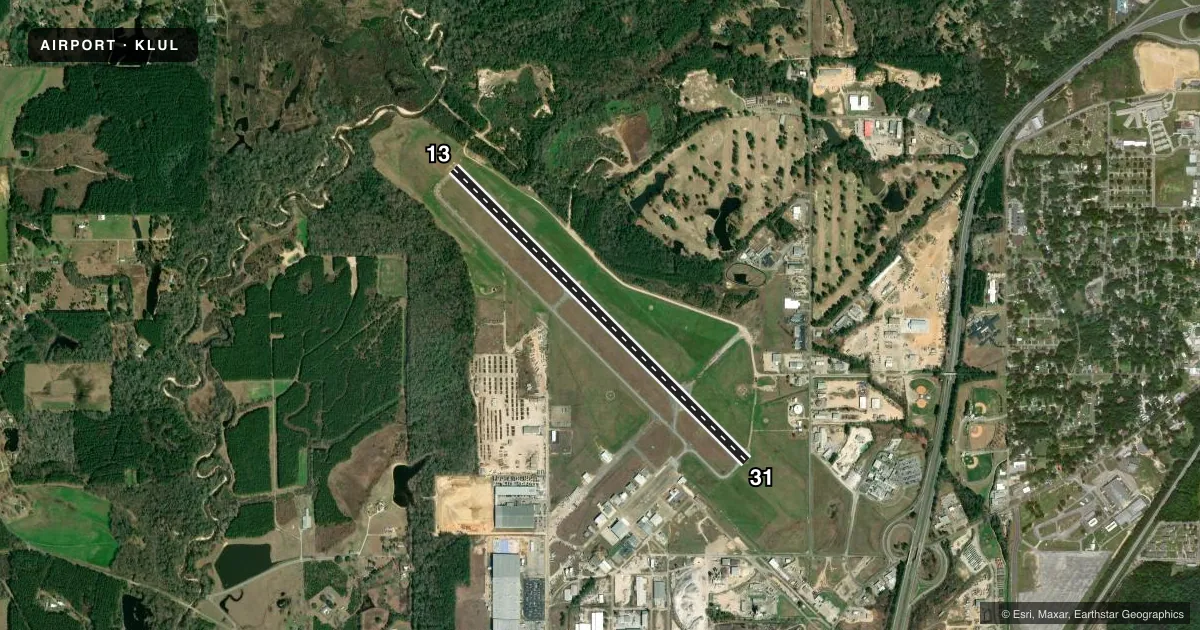
Runways & pattern
Full pagePattern entry · RWY 31
LEFT TRAFFICRunway end performance
| End | TORA | TODA | ASDA | LDA | VGSI | Approach lights | Obstruction |
|---|---|---|---|---|---|---|---|
| 13 | — | — | — | — | PAPI 4-box left(3°) | — | — |
| 31 | — | — | — | — | PAPI 4-box left(3°) | — | 55', trees, 2124' from thr, slope 34 |
Declared distances in feet. TORA = takeoff run available, TODA = takeoff distance, ASDA = accelerate-stop, LDA = landing distance.
Airport sketch
Runways drawn to scale from FAA survey coordinates, rendered over satellite imagery. Not for navigation.
Approaches & charts
Services on the field
Fuel grades, oxygen, maintenance, ramp storage and lighting — as declared to the FAA by the airport operator.
Fuel & services
- Fuel
- 100LLA1+
- Oxygen (bottled)
- Not available
- Oxygen (bulk)
- Not available
- Airframe repair
- Minor
- Power plant repair
- Minor
- Other services
- INSTR
Ramp & ground
- Transient storage
- Tie-down
- Hangar
- Landing fee
- No fee published
- Customs
- Not available
- Lighting schedule
- SEE RMK
- Beacon schedule
- SS-SR
- Beacon
- White / Green (civil land)(WG)
- Wind indicator
- Lighted
- Segmented circle
- Yes
Fuel & FBOs
Cheapest 100LL and Jet A on the field and nearby. Always confirm with the FBO before taxi.
Airport notes
Surface conditions, obstructions, local procedures, lighting outages and other notes published with each FAA cycle.
General notes
- ULTRALIGHT & CROP DUST ACTV INVOF ARPT.
- FOR CD IF UNA TO CTC ON FSS FREQ, CTC HOUSTON ARTCC AT 281-230-5622.
- COURTESY VEHICLE AVBL.
- AFT HRS SELF SVC FUEL AVBL WITH CREDIT CARD.
Lighting notes
- ACTVT REIL RWY 13; HIRL RWY 13/31 - CTAF. PAPI RWY 13 & 31 OPR CONSLY.
Approach & departure obstructions
- 31PAPI UNUSBL BYD 9 DEGS RIGHT OF CNTRLN.
Other notes
- 1AFT HR SVC CALL 601-426-2626.
VFR map & nearby airports
VFR sectional. Tap any ICAO chip to open that airport.
Key facts · KLUL
Answer card- ICAO
- KLUL
- Name
- HESLER/NOBLE FLD
- Location
- LAUREL, MISSISSIPPI
- Elevation
- 238.3 ft MSL
- Traffic pattern altitude
- 1,238.3 ft MSL (1,000 AGL)
- Control tower
- Non-towered (use CTAF)
- Total runways
- 1
- Longest runway
- 13/31 · 5,513 ft
- Published ILS approaches
- 0
- Published frequencies
- 2
- Magnetic variation
- 0°
- Current flight rules
- VFR
- Current wind
- 320° at 4 kt
- Favored runway now
- RWY 31
Hesler/Noble Fld sits in Laurel, Mississippi. Field elevation is 238.3 ft MSL. The airport has one runway. Runway 13/31 is 5,513 ft of asphalt. There is no control tower. CTAF and UNICOM are both 123.05. No ILS approaches are published here.
Pattern altitude is not published. Use 1,000 ft AGL for light piston traffic unless the current Chart Supplement says otherwise. The on-field FBO is Laurel Airport Authority. It carries 100LL, Jet A and Jet A Prist. Full-service fuel is available with credit card payment. A courtesy vehicle is available. After-hours service is available by calling the number in the remarks.
A few operational notes matter here. Runway 13 has end identifier lights that can be activated on CTAF. High intensity runway lights are available on both runway ends. The PAPI on 13 and 31 runs continuously. The PAPI on runway 31 is unusable beyond 9 degrees right of centerline. Ultralight and crop dusting activity occurs near the airport. That is worth keeping in mind on arrival and departure. If you need clearance delivery help, the remarks say to contact Houston ARTCC if Flight Service cannot be reached.