METAR & TAF M43
M43 does not publish a METAR.
Showing the nearest reporting station: KPIB (HATTIESBURG/LAUREL RGNL) · 30.1 NM away. Conditions at M43 may differ.
METAR · KPIB
Observed 19:56Z
KPIB 261956Z AUTO 22006KT 10SM BKN070 BKN085 36/21 A3002 RMK AO2 SLP160 T03610211 PWINO $
- Wind
- 220° @ 6 kt
- Visibility
- 10 SM
- Temp / Dew
- 36°C / 21°C
- Altimeter
- 30.02 inHg
- Clouds
- BKN
- Density alt
- 2,960 ft
- Ceiling
- 7,000 ft AGL
- Rules
- VFR
Airport info & contacts
Manager on record, flight service, ARTCC, attendance schedule and pattern altitude — published by the FAA and refreshed every 28 days.
Location
- From city
- 2 NM W
- VFR sectional
- NEW ORLEANS
- ARTCC
- ZHU · HOUSTON
- NOTAM facility
- GWO (NOTAM-D)
Airport manager
- Name
- LONNIE STEVERSON
- Phone
- 601-466-4959
- Address
- PO BOX 207, NEW HEBRON MS 39140
Flight service · Hours
- FSS GWO
- GREENWOOD1-800-WX-BRIEF
- Attendance
- Unattended
Frequencies
Tap any row to copy the frequency to your clipboard.
Runways & pattern
Full pagePattern entry · RWY 30
LEFT TRAFFICRunway end performance
| End | TORA | TODA | ASDA | LDA | VGSI | Approach lights | Obstruction |
|---|---|---|---|---|---|---|---|
| 12 | — | — | — | — | PAPI 2-box left(2.75°) | — | — |
| 30 | — | — | — | — | PAPI 2-box left(2.75°) | — | 44', trees, 1284' from thr, 250' R of cntrln, slope 24 |
Declared distances in feet. TORA = takeoff run available, TODA = takeoff distance, ASDA = accelerate-stop, LDA = landing distance.
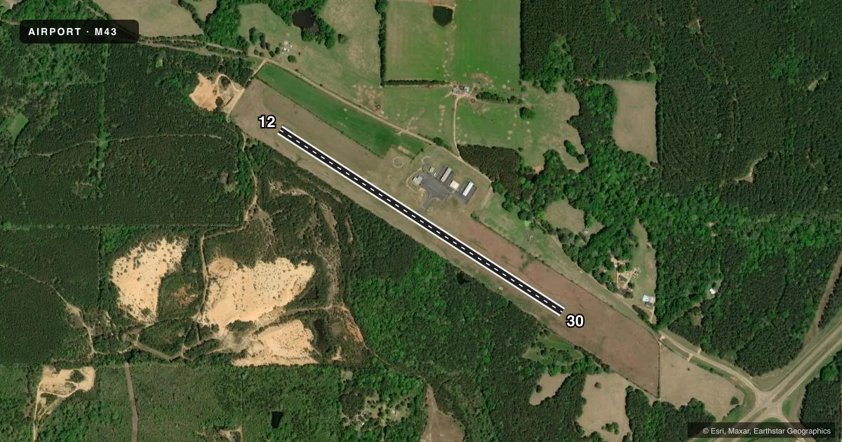
Airport sketch
Runways drawn to scale from FAA survey coordinates, rendered over satellite imagery. Not for navigation.
Approaches & charts
Services on the field
Fuel grades, oxygen, maintenance, ramp storage and lighting — as declared to the FAA by the airport operator.
Fuel & services
- Fuel
- 100LL
- Oxygen (bottled)
- Not available
- Oxygen (bulk)
- Not available
- Airframe repair
- Not available
- Power plant repair
- Not available
- Other services
- AGRI
Ramp & ground
- Transient storage
- Tie-down
- Landing fee
- No fee published
- Customs
- Not available
- Lighting schedule
- SEE RMK
- Beacon schedule
- SS-SR
- Beacon
- White / Green (civil land)(WG)
- Wind indicator
- Lighted
- Segmented circle
- Yes
Fuel & FBOs
Cheapest 100LL and Jet A on the field and nearby. Always confirm with the FBO before taxi.
Airport notes
Surface conditions, obstructions, local procedures, lighting outages and other notes published with each FAA cycle.
General notes
- FOR CD CTC HOUSTON ARTCC AT 281-230-5622.
Lighting notes
- ACTVT MIRL RWY 12/30 - CTAF.
Fuel notes
- 100LLAVBL 24 HR WITH CREDIT CARD.
Other notes
- THIS AIRPORT HAS BEEN SURVEYED BY THE NATIONAL GEODETIC SURVEY.
- LMTD TRANSIT PRKG SPACE; PILOTS MUST PRVD THEIR OWN TIEDOWN ROPES.
- 1FOR EMERG CALL POLICE DEPT 601-792-5198.
- OWNERCHARLES DUMAS.
VFR map & nearby airports
VFR sectional. Tap any ICAO chip to open that airport.
Key facts · M43
Answer card- ICAO
- M43
- Name
- PRENTISS-JEFFERSON DAVIS COUNTY
- Location
- PRENTISS, MISSISSIPPI
- Elevation
- 454.6 ft MSL
- Traffic pattern altitude
- 1,454.6 ft MSL (1,000 AGL)
- Control tower
- Non-towered (use CTAF)
- Total runways
- 1
- Longest runway
- 12/30 · 3,197 ft
- Published ILS approaches
- 0
- Published frequencies
- 2
- Magnetic variation
- 1°
- Current flight rules
- VFR
- Current wind
- 220° at 6 kt
- Favored runway now
- RWY 30
Prentiss-Jefferson Davis County Airport (M43) sits in Prentiss, Mississippi. Field elevation is 454.6 ft MSL. The airport has one runway, 12/30, which is 3,197 ft long and asphalt. There is no control tower. CTAF and UNICOM are both 122.8. No ILS approaches are published, so plan with the current chart and your own arrival setup.
Pattern altitude is not published. Use the standard 1,000 ft AGL pattern unless local procedures or current published guidance say otherwise. The airport is served by Steverson Aviation on the field. It carries 100LL. 100LL is also available 24 hours with a credit card. Limited transient parking space is available. Bring your own tiedown ropes if you plan to stop.
For night ops, runway lights on 12/30 are medium intensity and are activated by CTAF. Clearance delivery goes through Houston ARTCC. The owner is Charles Dumas. If you need help in an emergency, the published contact is the police department. This is a small non-towered field, so expect self-announce traffic and keep a close eye on spacing in the pattern.