METAR & TAF M11
M11 does not publish a METAR.
Showing the nearest reporting station: KJVW (JOHN BELL WILLIAMS) · 24.2 NM away. Conditions at M11 may differ.
METAR · KJVW
Observed 07:55Z
KJVW 270755Z AUTO 00000KT 6SM BR CLR 24/24 A2995 RMK A01
- Wind
- 000° @ 0 kt
- Visibility
- 6 SM
- Temp / Dew
- 24°C / 24°C
- Altimeter
- 29.95 inHg
- Clouds
- CLR
- Density alt
- 1,583 ft
- Ceiling
- Unlimited
- Rules
- VFR
Airport info & contacts
Manager on record, flight service, ARTCC, attendance schedule and pattern altitude — published by the FAA and refreshed every 28 days.
Location
- From city
- 4 NM S
- VFR sectional
- NEW ORLEANS
- ARTCC
- ZME · MEMPHIS
- NOTAM facility
- GWO (NOTAM-D)
Airport manager
- Name
- TOMMY RIALS
- Phone
- 601-594-2204
- Address
- 28090 HWY 51, CRYSTAL SPRINGS MS 39059
Flight service · Hours
- FSS GWO
- GREENWOOD1-800-WX-BRIEF
- Attendance
- MON-SAT · 0800-1700
Frequencies
Tap any row to copy the frequency to your clipboard.
Runways & pattern
Full pagePattern entry · RWY 18
LEFT TRAFFICRunway end performance
| End | TORA | TODA | ASDA | LDA | VGSI | Approach lights | Obstruction |
|---|---|---|---|---|---|---|---|
| 18 | — | — | — | — | PAPI 2-box right(4°) | — | — |
| 36 | — | — | — | — | PAPI 2-box left(3°) | — | 55', trees, 2000' from thr, 300' R of cntrln, slope 32 |
Declared distances in feet. TORA = takeoff run available, TODA = takeoff distance, ASDA = accelerate-stop, LDA = landing distance.
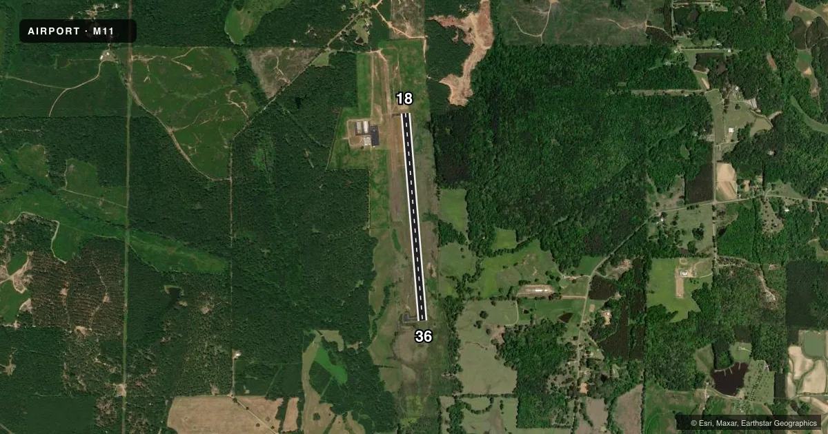
Airport sketch
Runways drawn to scale from FAA survey coordinates, rendered over satellite imagery. Not for navigation.
Approaches & charts
Services on the field
Fuel grades, oxygen, maintenance, ramp storage and lighting — as declared to the FAA by the airport operator.
Fuel & services
- Fuel
- 100LLA1
- Oxygen (bottled)
- Not available
- Oxygen (bulk)
- Not available
- Airframe repair
- Major
- Power plant repair
- Major
- Other services
- AGRI
Ramp & ground
- Transient storage
- Tie-down
- Hangar
- Landing fee
- No fee published
- Customs
- Not available
- Lighting schedule
- SS-SR
- Beacon schedule
- SS-SR
- Beacon
- White / Green (civil land)(WG)
- Wind indicator
- Yes
- Segmented circle
- No
Fuel & FBOs
Cheapest 100LL and Jet A on the field and nearby. Always confirm with the FBO before taxi.
Airport notes
Surface conditions, obstructions, local procedures, lighting outages and other notes published with each FAA cycle.
General notes
- FOR CD CTC MEMPHIS ARTCC AT 901-368-8453/8449.
- COURTESY CAR AVBL.
Fuel notes
- 100LLFUEL 24 HRS WITH CREDIT CARD.
Other notes
- LCTD 3 SM NE OF HAZLEHURST.
- PILOTS MUST PRVD TIEDOWN ROPES.
- 3AFT HR CTC AMGR.
- OWNERDAVID ENGEL.
VFR map & nearby airports
VFR sectional. Tap any ICAO chip to open that airport.
Key facts · M11
Answer card- ICAO
- M11
- Name
- COPIAH COUNTY
- Location
- CRYSTAL SPRINGS, MISSISSIPPI
- Elevation
- 435.4 ft MSL
- Traffic pattern altitude
- 1,435.4 ft MSL (1,000 AGL)
- Control tower
- Non-towered (use CTAF)
- Total runways
- 1
- Longest runway
- 18/36 · 4,007 ft
- Published ILS approaches
- 0
- Published frequencies
- 1
- Magnetic variation
- 1°
- Current flight rules
- VFR
- Current wind
- 000° at 0 kt
- Favored runway now
- –
Copiah County Airport sits in Crystal Springs, Mississippi. The field elevation is 435.4 ft MSL. It has one runway. Runway 18/36 is 4,007 ft of asphalt, so plan your landing and takeoff performance with that length in mind.
There is no control tower. CTAF is 122.9. No ILS approaches are published here, so check the current charting for any approach options before you go. The pattern altitude is not published in the facts, so use the standard 1,000 ft AGL for light piston traffic unless the current Chart Supplement says otherwise. That puts the pattern at about 1,435 ft MSL based on the listed field elevation.
Eagle One Aviation is on the field. It carries 100LL and Jet A. Fuel is available 24 hours with credit card. The published remarks also say a courtesy car is available. Pilots should bring tiedown ropes. If you need clearance delivery, the published contact is Memphis ARTCC. After hours, contact the airport manager. The airport is listed about 3 statute miles northeast of Hazlehurst. With no tower and no published ILS, a good scan of the current Chart Supplement and a clean CTAF callout matter here.