METAR & TAF KMBO
Current METAR
Observed 10:35Z
KMBO 271035Z AUTO 26007KT 10SM CLR 26/23 A2996 RMK AO2
- Wind
- 260° @ 7 kt
- Visibility
- 10 SM
- Temp / Dew
- 26°C / 23°C
- Altimeter
- 29.96 inHg
- Clouds
- CLR
- Density alt
- 1,674 ft
- Ceiling
- Unlimited
- Rules
- VFR
Airport info & contacts
Manager on record, flight service, ARTCC, attendance schedule and pattern altitude — published by the FAA and refreshed every 28 days.
Location
- From city
- 2 NM SE
- VFR sectional
- MEMPHIS
- ARTCC
- ZME · MEMPHIS
- NOTAM facility
- GWO (NOTAM-D)
Airport manager
- Name
- GUY BOWERING
- Phone
- 601-853-1960
- Address
- PO BOX 40, MADISON MS 39130
Flight service · Hours
- FSS GWO
- GREENWOOD1-800-WX-BRIEF
- Attendance
- MON-FRI · 0600-1900
- SAT-SUN · 0700-1700
Frequencies
Tap any row to copy the frequency to your clipboard.
Runways & pattern
Full pagePattern entry · RWY 17
LEFT TRAFFICRunway end performance
| End | TORA | TODA | ASDA | LDA | VGSI | Approach lights | Obstruction |
|---|---|---|---|---|---|---|---|
| 17 | — | — | — | — | PAPI 2-box left(3°) | — | 66', trees, 1540' from thr, 200' R of cntrln, slope 20 |
| 35 | — | — | — | — | PAPI 2-box left(4°) | — | 71', trees, 1650' from thr, 200' R of cntrln, slope 20 |
Declared distances in feet. TORA = takeoff run available, TODA = takeoff distance, ASDA = accelerate-stop, LDA = landing distance.
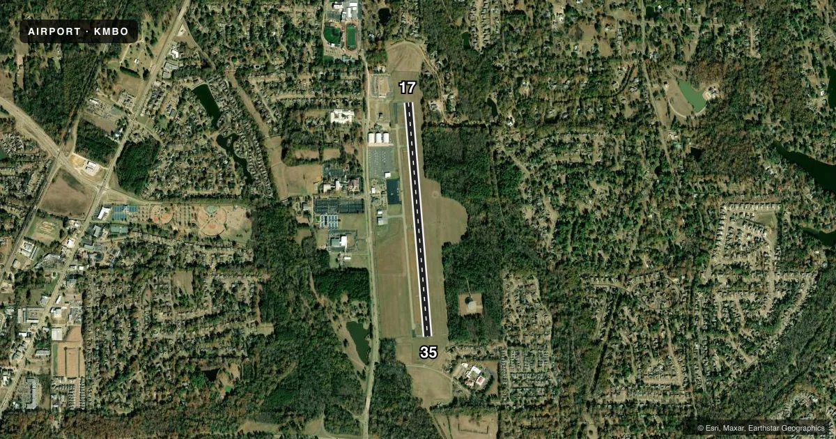
Airport sketch
Runways drawn to scale from FAA survey coordinates, rendered over satellite imagery. Not for navigation.
Approaches & charts
Services on the field
Fuel grades, oxygen, maintenance, ramp storage and lighting — as declared to the FAA by the airport operator.
Fuel & services
- Fuel
- 100LLA1+
- Oxygen (bulk)
- Not available
- Airframe repair
- Minor
- Power plant repair
- Minor
- Other services
- INSTR,RNTL
Ramp & ground
- Transient storage
- Tie-down
- Hangar
- Landing fee
- No fee published
- Customs
- Not available
- Lighting schedule
- SEE RMK
- Beacon schedule
- SS-SR
- Beacon
- White / Green (civil land)(WG)
- Wind indicator
- Lighted
- Segmented circle
- Yes
Fuel & FBOs
Cheapest 100LL and Jet A on the field and nearby. Always confirm with the FBO before taxi.
Airport notes
Surface conditions, obstructions, local procedures, lighting outages and other notes published with each FAA cycle.
General notes
- WHEN APCH CLSD, FOR CD CTC MEMPHIS ARTCC AT 901-368-8453/8449.
Lighting notes
- ACTVT PAPI RWY 17 & 35; MIRL RWY 17/35 - CTAF.
Approach & departure obstructions
- 35PAPI OTS INDEF.
VFR map & nearby airports
VFR sectional. Tap any ICAO chip to open that airport.
Key facts · KMBO
Answer card- ICAO
- KMBO
- Name
- BRUCE CAMPBELL FLD
- Location
- MADISON, MISSISSIPPI
- Elevation
- 325.1 ft MSL
- Traffic pattern altitude
- 1,325.1 ft MSL (1,000 AGL)
- Control tower
- Non-towered (use CTAF)
- Total runways
- 1
- Longest runway
- 17/35 · 4,444 ft
- Published ILS approaches
- 0
- Published frequencies
- 7
- Magnetic variation
- 1°
- Current flight rules
- VFR
- Current wind
- 260° at 7 kt
- Favored runway now
- RWY 17
Bruce Campbell Fld (KMBO) sits in Madison, Mississippi. The field elevation is 325.1 ft MSL. It has one asphalt runway, 17/35, which is 4,444 ft long. There is no control tower. The pattern altitude is not published, so use the standard 1,000 ft AGL for light piston traffic unless the current Chart Supplement says otherwise.
No ILS approaches are published here. That makes the weather picture more important when you are planning the arrival. The airport is served by Madison Air Center on the field. It carries 100LL and Jet A Prist. If you need a fuel stop, call ahead at (601) 853-1960.
A few published remarks matter for a first-time visit. The PAPI on runway 35 is out of service indefinitely. The PAPI on runways 17 and 35 is activated by CTAF. The medium intensity runway lights on 17 and 35 are also CTAF-activated. If you are coming in after dark, verify the lighting setup before you launch. When approach is closed, clearance delivery goes through Memphis ARTCC at 901-368-8453 or 901-368-8449. Check the current FAA Chart Supplement for any noise or curfew restrictions before flying in. Also confirm the current airspace picture on the sectional or TAC, since that is the safest source for a field like this.