METAR & TAF KJVW
Current METAR
Observed 11:55Z
KJVW 271155Z AUTO 00000KT 7SM FEW075 24/24 A2999 RMK A01
- Wind
- 000° @ 0 kt
- Visibility
- 7 SM
- Temp / Dew
- 24°C / 24°C
- Altimeter
- 29.99 inHg
- Clouds
- FEW
- Density alt
- 1,299 ft
- Ceiling
- Unlimited
- Rules
- VFR
Airport info & contacts
Manager on record, flight service, ARTCC, attendance schedule and pattern altitude — published by the FAA and refreshed every 28 days.
Location
- From city
- 3 NM NE
- VFR sectional
- MEMPHIS
- ARTCC
- ZME · MEMPHIS
- NOTAM facility
- GWO (NOTAM-D)
Airport manager
- Name
- HIRAM HANEY
- Phone
- 601-857-3884
- Address
- HINDS COMMUNITY COLLEGE, P.O. BOX 1100, RAYMOND MS 39154
Flight service · Hours
- FSS GWO
- GREENWOOD1-800-WX-BRIEF
- Attendance
- MON-FRI · 0800-1700
- SAT · 0800-1200
Frequencies
Tap any row to copy the frequency to your clipboard.
Runways & pattern
Full pagePattern entry · RWY 12
LEFT TRAFFICRunway end performance
| End | TORA | TODA | ASDA | LDA | VGSI | Approach lights | Obstruction |
|---|---|---|---|---|---|---|---|
| 12 | — | — | — | — | PAPI 4-box left(3°) | — | — |
| 30 | — | — | — | — | PAPI 2-box left(4°) | — | 80', trees, 1250' from thr, slope 13 |
Declared distances in feet. TORA = takeoff run available, TODA = takeoff distance, ASDA = accelerate-stop, LDA = landing distance.
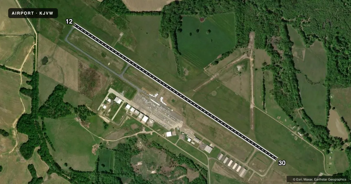
Airport sketch
Runways drawn to scale from FAA survey coordinates, rendered over satellite imagery. Not for navigation.
Approaches & charts
ILS · 1
Services on the field
Fuel grades, oxygen, maintenance, ramp storage and lighting — as declared to the FAA by the airport operator.
Fuel & services
- Fuel
- 100LLA
- Oxygen (bottled)
- Not available
- Oxygen (bulk)
- Not available
- Airframe repair
- Major
- Power plant repair
- Major
- Other services
- INSTR,RNTL
Ramp & ground
- Transient storage
- Tie-down
- Hangar
- Landing fee
- No fee published
- Customs
- Not available
- Lighting schedule
- SEE RMK
- Beacon schedule
- SS-SR
- Beacon
- White / Green (civil land)(WG)
- Wind indicator
- Lighted
- Segmented circle
- Yes
Fuel & FBOs
Cheapest 100LL and Jet A on the field and nearby. Always confirm with the FBO before taxi.
Airport notes
Surface conditions, obstructions, local procedures, lighting outages and other notes published with each FAA cycle.
General notes
- WHEN APCH CLSD, FOR CD CTC MEMPHIS ARTCC AT 901-368-8453/8449.
- PAINT FAC.
- COURTESY CAR AVBL.
Lighting notes
- ACTVT REIL RWY 12 & 30; MIRL RWY 12/30 - CTAF. PAPI RWY 12 & 30 OPR CONSLY.
Fuel notes
- 100LLFUEL AVBL 24 HRS WITH CREDIT CARD.
Other notes
- PRIOR TO FAA ACT.
- PILOTS MUST PRVD THEIR OWN TIEDOWN ROPES.
VFR map & nearby airports
VFR sectional. Tap any ICAO chip to open that airport.
Key facts · KJVW
Answer card- ICAO
- KJVW
- Name
- JOHN BELL WILLIAMS
- Location
- RAYMOND, MISSISSIPPI
- Elevation
- 247 ft MSL
- Traffic pattern altitude
- 1,247 ft MSL (1,000 AGL)
- Control tower
- Non-towered (use CTAF)
- Total runways
- 1
- Longest runway
- 12/30 · 5,499 ft
- Published ILS approaches
- 1
- Published frequencies
- 4
- Magnetic variation
- 0°
- Current flight rules
- VFR
- Current wind
- 000° at 0 kt
- Favored runway now
- –
John Bell Williams Airport sits in Raymond, Mississippi. The field elevation is 247 ft MSL. It has one runway, 12/30, which is 5,499 ft long. There is no control tower. Pattern altitude is not published, so use standard 1,000 ft AGL for light piston operations unless the Chart Supplement says otherwise.
The airport has one ILS approach on runway 12. Runway 12 and runway 30 both have runway end identifier lights. Medium intensity runway lights are on both ends. They are controlled by CTAF. PAPI is available on both runway ends and operates continuously. That helps after dark, since the field is non-towered.
Hinds Community College is on the field. It carries 100LL, Jet A and Jet A Prist. Fuel is available 24 hours with credit card. A courtesy car is available. Pilots must bring their own tiedown ropes. If you need clearance delivery when approach is closed, contact Memphis ARTCC using the numbers in the Chart Supplement. For a first visit, plan for a non-towered arrival on CTAF 123.0 or UNICOM 123.0. Check the current FAA Chart Supplement for any noise or operating notes before you go.