METAR & TAF KVKS
Current METAR
Observed 02:15Z
KVKS 250215Z AUTO 00000KT 10SM CLR 28/28 A3004 RMK A01
- Wind
- 000° @ 0 kt
- Visibility
- 10 SM
- Temp / Dew
- 28°C / 28°C
- Altimeter
- 30.04 inHg
- Clouds
- CLR
- Density alt
- 1,544 ft
- Ceiling
- Unlimited
- Rules
- VFR
Airport info & contacts
Manager on record, flight service, ARTCC, attendance schedule and pattern altitude — published by the FAA and refreshed every 28 days.
Location
- From city
- 7 NM SW
- VFR sectional
- MEMPHIS
- ARTCC
- ZME · MEMPHIS
- NOTAM facility
- GWO (NOTAM-D)
Airport manager
- Name
- RON DAVIS
- Phone
- 601-218-5789
- Address
- 5855 HIGHWAY 61 SOUTH, VICKSBURG MS 39180
Flight service · Hours
- FSS GWO
- GREENWOOD1-800-WX-BRIEF
- Attendance
- MON-FRI · 0600-1700
Frequencies
Tap any row to copy the frequency to your clipboard.
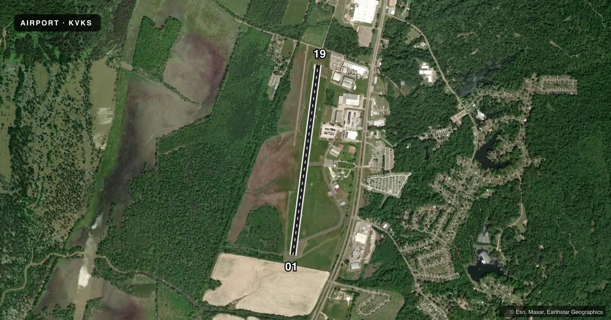
Runways & pattern
Full pagePattern entry · RWY 01
LEFT TRAFFICRunway end performance
| End | TORA | TODA | ASDA | LDA | VGSI | Approach lights | Obstruction |
|---|---|---|---|---|---|---|---|
| 01 | — | — | — | — | PAPI 2-box right(3°) | — | 105', trees, 2500' from thr, 0' R of cntrln, slope 21 |
| 19 | — | — | — | — | PAPI 2-box left(3°) | — | 38', tree, 1100' from thr, 200' R of cntrln, slope 23 |
Declared distances in feet. TORA = takeoff run available, TODA = takeoff distance, ASDA = accelerate-stop, LDA = landing distance.
Airport sketch
Runways drawn to scale from FAA survey coordinates, rendered over satellite imagery. Not for navigation.
Approaches & charts
Services on the field
Fuel grades, oxygen, maintenance, ramp storage and lighting — as declared to the FAA by the airport operator.
Fuel & services
- Fuel
- 100LLA+A1+J
- Oxygen (bottled)
- Not available
- Oxygen (bulk)
- Not available
- Airframe repair
- Not available
- Power plant repair
- Not available
- Other services
- INSTR,RNTL
Ramp & ground
- Transient storage
- Tie-down
- Hangar
- Landing fee
- No fee published
- Customs
- Not available
- Lighting schedule
- SEE RMK
- Beacon schedule
- SS-SR
- Beacon
- White / Green (civil land)(WG)
- Wind indicator
- Lighted
- Segmented circle
- Yes
Fuel & FBOs
Cheapest 100LL and Jet A on the field and nearby. Always confirm with the FBO before taxi.
Airport notes
Surface conditions, obstructions, local procedures, lighting outages and other notes published with each FAA cycle.
General notes
- N PARL TWY CLSD.
- TERM STUB TWY ONLY.
- FOR CD CTC MEMPHIS ARTCC AT 901-368-8453/8449.
Lighting notes
- ACTVT PAPI RWY 19; MIRL RWY 01/19 - CTAF. PAPI RWY 01 OPR CONSLY.
Fuel notes
- 100LLFUEL 24 HRS WITH CREDIT CARD.
Approach & departure obstructions
- 01APCH RATIO 28:1 TO DTHR.
- 19APCH RATIO 41:1 TO DTHR.
Other notes
- AVBL 601-529-2909.
- EXISTED PRIOR TO 1959.
- AVBL 601-529-2909.
- HNGR FEE RQRD.
- 3AFT HRS CALL 601-218-5428. CALL OUT FEE RQRD.
VFR map & nearby airports
VFR sectional. Tap any ICAO chip to open that airport.
Key facts · KVKS
Answer card- ICAO
- KVKS
- Name
- VICKSBURG MUNI
- Location
- VICKSBURG, MISSISSIPPI
- Elevation
- 107 ft MSL
- Traffic pattern altitude
- 1,107 ft MSL (1,000 AGL)
- Control tower
- Non-towered (use CTAF)
- Total runways
- 1
- Longest runway
- 01/19 · 5,000 ft
- Published ILS approaches
- 0
- Published frequencies
- 2
- Magnetic variation
- 0°
- Current flight rules
- VFR
- Current wind
- 000° at 0 kt
- Favored runway now
- –
Vicksburg Muni is in Vicksburg, Mississippi. Field elevation is 107 ft MSL. The airport has one runway, 01/19, which is 5,000 ft long. There is no control tower. CTAF and UNICOM are both 122.8. No ILS approaches are published here.
The pattern altitude is not published. Use the standard 1,000 ft AGL for light piston traffic unless the current Chart Supplement says otherwise. The field has one on-field FBO, Vicksburg Municipal Airport. It carries AVGAS 100LL and Jet A. 100LL is available 24 hours with a credit card. The airport also notes a hangar fee. After hours, call the number in the Chart Supplement. A call out fee applies.
A few operational notes matter here. The north parallel taxiway is closed. Only a terminal stub taxiway is available. Clearance delivery is handled through Memphis ARTCC. Runway 19 has a PAPI that operates continuously. Runway 01 also has a PAPI. Medium intensity runway lighting is available on both runways and is controlled on CTAF. The published approach clearance slopes for the runways are tight, so plan your descent and stabilization early. If you need repair support, airframe and power plant service are listed on field. Check the current Chart Supplement before departure for any updates to procedures or restrictions.