METAR & TAF L33
L33 does not publish a METAR.
Showing the nearest reporting station: KHEZ (HARDY-ANDERS FLD/NATCHEZ-ADAMS COUNTY) · 21.8 NM away. Conditions at L33 may differ.
METAR · KHEZ
Observed 03:56Z
KHEZ 270356Z AUTO 00000KT 10SM CLR 27/25 A2999 RMK AO2 SLP153 T02670250 $
- Wind
- 000° @ 0 kt
- Visibility
- 10 SM
- Temp / Dew
- 27°C / 25°C
- Altimeter
- 29.99 inHg
- Clouds
- CLR
- Density alt
- 1,445 ft
- Ceiling
- Unlimited
- Rules
- VFR
Airport info & contacts
Manager on record, flight service, ARTCC, attendance schedule and pattern altitude — published by the FAA and refreshed every 28 days.
Location
- From city
- 4 NM NE
- VFR sectional
- HOUSTON
- ARTCC
- ZME · MEMPHIS
- NOTAM facility
- DRI (NOTAM-D)
Airport manager
- Name
- RON WILHITE
- Phone
- (318) 537-1475
- Address
- PO BOX 557, ST JOSEPH LA 71366
Flight service · Hours
- FSS DRI
- DE RIDDER1-800-WX-BRIEF
- Attendance
- Unattended
Frequencies
Tap any row to copy the frequency to your clipboard.
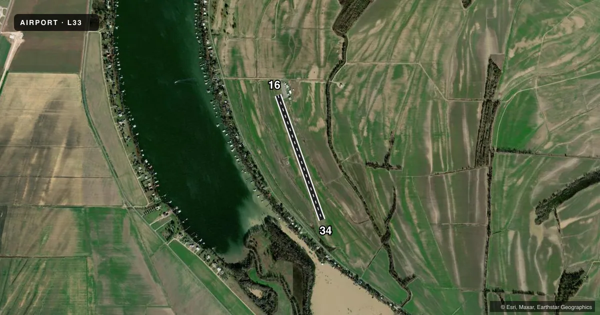
Runways & pattern
Full pagePattern entry · RWY 16
LEFT TRAFFICRunway end performance
| End | TORA | TODA | ASDA | LDA | VGSI | Approach lights | Obstruction |
|---|---|---|---|---|---|---|---|
| 16 | — | — | — | — | — | — | 15', road, 435' from thr, 0' R of cntrln, slope 15 |
| 34 | — | — | — | — | — | — | 68', trees, 1486' from thr, 0' R of cntrln, slope 18 |
Declared distances in feet. TORA = takeoff run available, TODA = takeoff distance, ASDA = accelerate-stop, LDA = landing distance.
Airport sketch
Runways drawn to scale from FAA survey coordinates, rendered over satellite imagery. Not for navigation.
Approaches & charts
Services on the field
Fuel grades, oxygen, maintenance, ramp storage and lighting — as declared to the FAA by the airport operator.
Fuel & services
- Fuel
- 100LL
- Other services
- AMB
Ramp & ground
- Transient storage
- Tie-down
- Landing fee
- No fee published
- Lighting schedule
- SEE RMK
- Beacon schedule
- SS-SR
- Beacon
- White / Green (civil land)(WG)
- Wind indicator
- Lighted
- Segmented circle
- Yes
Fuel & FBOs
Cheapest 100LL and Jet A on the field and nearby. Always confirm with the FBO before taxi.
Airport notes
Surface conditions, obstructions, local procedures, lighting outages and other notes published with each FAA cycle.
General notes
- BIRDS IN VICINITY OF AIRPORT.
- FOR CD CTC MEMPHIS ARTCC AT 901-368-8453/8449.
- (WIND INDICATOR) WINDSOCK OTS TEMPOLY.
- CTC ARPT MGR FOR DSGND RAMP SPACE FOR PUB USE.
Lighting notes
- MIRL RY 16/34 PRESET LOW INTST; TO INCR INTST ACTVT - CTAF.
Other notes
- TFC PATTERN OERATIONS AT ST JOSEPH MUNI CONDUCTED ON W SIDE OF RY OR ALL TFC PATTERN OPERATIONS AT HUNTER MAY ARPT CONDUCTED E SIDE RY.
- 2FOR ARPT ATTENDANT CALL 318-282-0348 OR 318-372-7277.
VFR map & nearby airports
VFR sectional. Tap any ICAO chip to open that airport.
Key facts · L33
Answer card- ICAO
- L33
- Name
- TENSAS PARISH
- Location
- ST JOSEPH, LOUISIANA
- Elevation
- 74.2 ft MSL
- Traffic pattern altitude
- 1,074.2 ft MSL (1,000 AGL)
- Control tower
- Non-towered (use CTAF)
- Total runways
- 1
- Longest runway
- 16/34 · 3,509 ft
- Published ILS approaches
- 0
- Published frequencies
- 1
- Magnetic variation
- 4°
- Current flight rules
- VFR
- Current wind
- 000° at 0 kt
- Favored runway now
- –
Tensas Parish Airport sits in St Joseph, Louisiana. Field elevation is 74.2 ft MSL. The airport has one runway, 16/34, which is 3,509 ft asphalt. There is no control tower. CTAF is 122.9.
No ILS approaches are published here. Pattern altitude is not published, so use the standard 1,000 ft AGL pattern unless the current Chart Supplement or local procedures say otherwise. The runway lights on 16/34 are medium intensity lights that come up at low intensity by default. Use the CTAF to increase intensity. That matters after sunset or in low visibility.
Published remarks also note birds in the area. The windsock is temporarily out of service, so do not rely on it alone for the wind picture. Clearance delivery is handled through Memphis ARTCC at the published phone numbers. If you need ramp space for public use, contact the airport manager first. There are no on-field FBOs listed, so verify fuel and service availability with the airport operator or by calling the field before arrival. For traffic pattern work, use the west side of the runway at St Joseph Municipal. If you are operating nearby at Hunter May Airport, pattern traffic is on the east side of the runway.