METAR & TAF 0R4
Current METAR
Observed 09:15Z
K0R4 270915Z AUTO 00000KT 10SM CLR 25/23 A2999 RMK AO2 T02480230
- Wind
- 000° @ 0 kt
- Visibility
- 10 SM
- Temp / Dew
- 25°C / 23°C
- Altimeter
- 29.99 inHg
- Clouds
- CLR
- Density alt
- 1,181 ft
- Ceiling
- Unlimited
- Rules
- VFR
Airport info & contacts
Manager on record, flight service, ARTCC, attendance schedule and pattern altitude — published by the FAA and refreshed every 28 days.
Location
- From city
- 4 NM W
- VFR sectional
- HOUSTON
- ARTCC
- ZHU · HOUSTON
- NOTAM facility
- DRI (NOTAM-D)
Airport manager
- Name
- CARL D. SAYERS
- Phone
- 318-336-8537
- Address
- 359 NATIONAL GUARD ROAD, VIDALIA LA 71373
Flight service · Hours
- FSS DRI
- DE RIDDER1-800-WX-BRIEF
- Attendance
- Unattended
Frequencies
Tap any row to copy the frequency to your clipboard.
Runways & pattern
Full pagePattern entry · RWY 14
LEFT TRAFFICRunway end performance
| End | TORA | TODA | ASDA | LDA | VGSI | Approach lights | Obstruction |
|---|---|---|---|---|---|---|---|
| 14 | — | — | — | — | PAPI 2-box left(3°) | — | 77', trees, 1368' from thr, 589' R of cntrln, slope 15 |
| 32 | — | — | — | — | PAPI 2-box left(3°) | — | — |
Declared distances in feet. TORA = takeoff run available, TODA = takeoff distance, ASDA = accelerate-stop, LDA = landing distance.
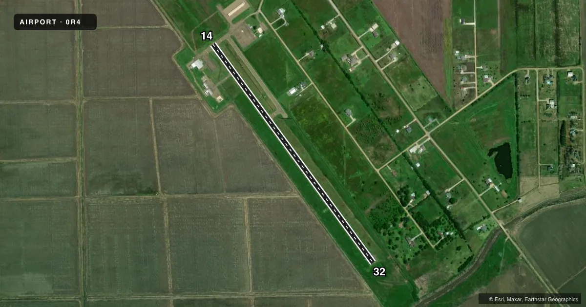
Airport sketch
Runways drawn to scale from FAA survey coordinates, rendered over satellite imagery. Not for navigation.
Approaches & charts
Services on the field
Fuel grades, oxygen, maintenance, ramp storage and lighting — as declared to the FAA by the airport operator.
Fuel & services
- Fuel
- 100LL
- Oxygen (bottled)
- Not available
- Oxygen (bulk)
- Not available
- Other services
- AGRI
Ramp & ground
- Transient storage
- Tie-down
- Landing fee
- No fee published
- Customs
- Not available
- Lighting schedule
- SEE RMK
- Beacon schedule
- SS-SR
- Beacon
- White / Green (civil land)(WG)
- Wind indicator
- Lighted
- Segmented circle
- No
Fuel & FBOs
Cheapest 100LL and Jet A on the field and nearby. Always confirm with the FBO before taxi.
Airport notes
Surface conditions, obstructions, local procedures, lighting outages and other notes published with each FAA cycle.
General notes
- 400 FT TWR 2 MILES NORTH OF APCH END RY 14.
- RWY 32 75 FT TREES EAST OF RWY PENETRATE TRANSITION SLOPE.
- FOR CD CTC HOUSTON ARTCC AT 281-230-5622.
- CTC ARPT MGR FOR DSNGD RAMP SPACE FOR PUB USE AT ARPT
Lighting notes
- REIL RWYS 14 & 32; MIRL RWY 14/32 PRESET LOW INTST; TO INCR INTST ACTVT - CTAF. PAPI RWY 14 AND 32 OPR CONSLY.
Fuel notes
- 100LL100LL AVBL 24 HRS SELF SERVICE WITH CREDIT CARD.
Approach & departure obstructions
- 14PAPI UNUSBL BYD 8 DEG RIGHT OF CNTRLN.
Other notes
- MANAGERAIRPORT PHONE 318-336-8537.
VFR map & nearby airports
VFR sectional. Tap any ICAO chip to open that airport.
Key facts · 0R4
Answer card- ICAO
- 0R4
- Name
- CONCORDIA PARISH
- Location
- VIDALIA, LOUISIANA
- Elevation
- 54.7 ft MSL
- Traffic pattern altitude
- 1,054.7 ft MSL (1,000 AGL)
- Control tower
- Non-towered (use CTAF)
- Total runways
- 1
- Longest runway
- 14/32 · 3,701 ft
- Published ILS approaches
- 0
- Published frequencies
- 2
- Magnetic variation
- 0°
- Current flight rules
- VFR
- Current wind
- 000° at 0 kt
- Favored runway now
- –
Concordia Parish Airport (0R4) sits in Vidalia, Louisiana. The field elevation is 54.7 ft MSL. It has one runway, 14/32, which is 3,701 ft long and paved with asphalt. There is no control tower. CTAF and UNICOM are both 122.8.
No ILS approaches are published here. The pattern altitude is not published in the facts, so use the standard 1,000 ft AGL for light piston operations unless the current FAA Chart Supplement says otherwise. The airport has runway end identifier lights on 14 and 32. The medium intensity runway lights are preset to low intensity. Use the CTAF to increase them. The PAPI on both ends runs continuously.
Concordia Parish Airport Authority is on the field. It carries 100LL. Self-serve 100LL is available 24 hours with credit card. Contact the airport manager for designated ramp space before you arrive. There is a 400 ft tower 2 miles north of the approach end of runway 14. Trees east of runway 32 penetrate the transition slope. The PAPI on runway 14 is unusable beyond 8 degrees right of centerline. For clearance delivery, contact Houston ARTCC at 281-230-5622.