METAR & TAF C71
C71 does not publish a METAR.
Showing the nearest reporting station: KHEZ (HARDY-ANDERS FLD/NATCHEZ-ADAMS COUNTY) · 22.8 NM away. Conditions at C71 may differ.
METAR · KHEZ
Observed 17:56Z
KHEZ 251756Z AUTO 30006KT 10SM FEW029 31/24 A3012 RMK AO2 SLP198 T03110239 10317 20261 58009 $
- Wind
- 300° @ 6 kt
- Visibility
- 10 SM
- Temp / Dew
- 31°C / 24°C
- Altimeter
- 30.12 inHg
- Clouds
- FEW
- Density alt
- 2,089 ft
- Ceiling
- Unlimited
- Rules
- VFR
Airport info & contacts
Manager on record, flight service, ARTCC, attendance schedule and pattern altitude — published by the FAA and refreshed every 28 days.
Location
- From city
- 1 NM NE
- VFR sectional
- HOUSTON
- ARTCC
- ZHU · HOUSTON
- NOTAM facility
- GWO (NOTAM-D)
Airport manager
- Name
- GLEN HALL
- Phone
- 601-639-4516
- Address
- BOX 338, CROSBY MS 39633
Flight service · Hours
- FSS GWO
- GREENWOOD1-800-WX-BRIEF
- Attendance
- Unattended
Frequencies
Tap any row to copy the frequency to your clipboard.
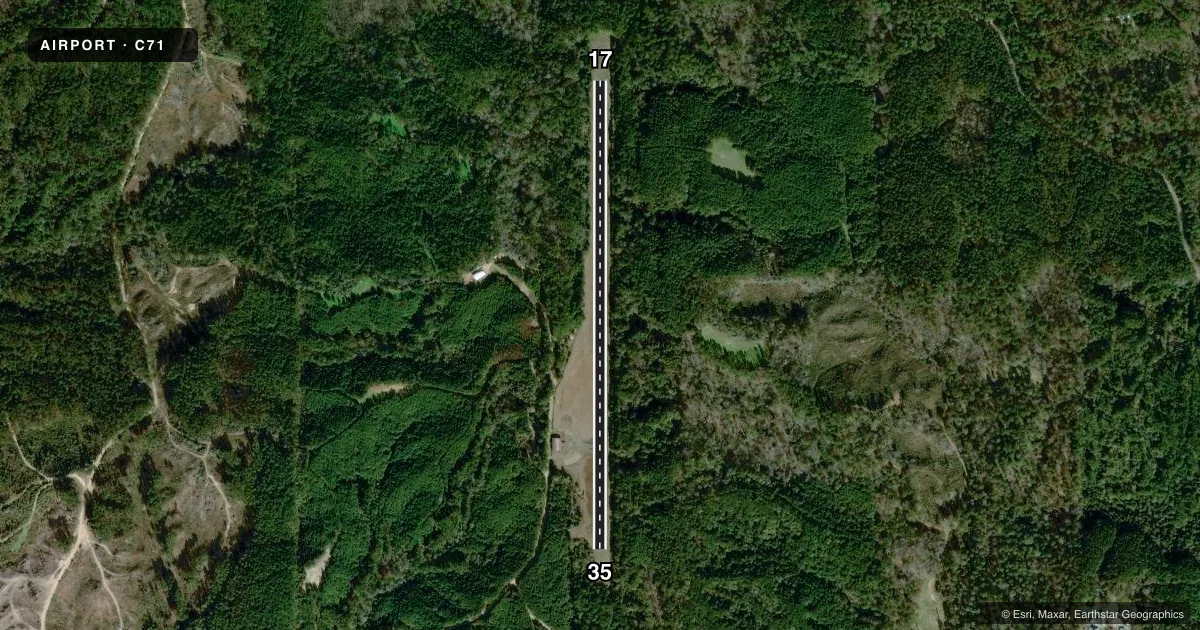
Runways & pattern
Full pagePattern entry · RWY 35
LEFT TRAFFICRunway end performance
| End | TORA | TODA | ASDA | LDA | VGSI | Approach lights | Obstruction |
|---|---|---|---|---|---|---|---|
| 17 | — | — | — | — | — | — | 51', trees, 330' from thr, 100' R of cntrln, slope 2 |
| 35 | — | — | — | — | — | — | 28', trees, 260' from thr, 50' R of cntrln, slope 1 |
Declared distances in feet. TORA = takeoff run available, TODA = takeoff distance, ASDA = accelerate-stop, LDA = landing distance.
Airport sketch
Runways drawn to scale from FAA survey coordinates, rendered over satellite imagery. Not for navigation.
Approaches & charts
Services on the field
Fuel grades, oxygen, maintenance, ramp storage and lighting — as declared to the FAA by the airport operator.
Fuel & services
- Fuel
- Not available
- Oxygen (bottled)
- Not available
- Oxygen (bulk)
- Not available
- Airframe repair
- Not available
- Power plant repair
- Not available
- Other services
- AGRI
Ramp & ground
- Transient storage
- Tie-down
- Landing fee
- No fee published
- Customs
- Not available
- Wind indicator
- Lighted
- Segmented circle
- Yes
Fuel & FBOs
Cheapest 100LL and Jet A on the field and nearby. Always confirm with the FBO before taxi.
Airport notes
Surface conditions, obstructions, local procedures, lighting outages and other notes published with each FAA cycle.
General notes
- DEER ON & INVOF ARPT.
- RWY MARKINGS FADED.
- FOR CD CTC HOUSTON ARTCC AT 281-230-5622.
Approach & departure obstructions
- 173-23 FT TREES & BUSHES 120 FT EITHER SIDE OF RWY.
- 353-20 FT TREES & BUSHES 120 FT EITHER SIDE OF RWY.
Other notes
- PRVDD ALL OPNS VFR ONLY; APCHS TO EACH RY ARE CLEAR 20:1; MEET DESIGN STANDARDS IN A/C 150/5300-13.
- PILOTS MUST PRVD THEIR OWN TIEDOWN ROPES.
- LGTS OTS.
- OWNERGLEN HALL.
- MANAGER601-730-8230.
VFR map & nearby airports
VFR sectional. Tap any ICAO chip to open that airport.
Key facts · C71
Answer card- ICAO
- C71
- Name
- CROSBY MUNI
- Location
- CROSBY, MISSISSIPPI
- Elevation
- 336 ft MSL
- Traffic pattern altitude
- 1,336 ft MSL (1,000 AGL)
- Control tower
- Non-towered (use CTAF)
- Total runways
- 1
- Longest runway
- 17/35 · 3,127 ft
- Published ILS approaches
- 0
- Published frequencies
- 1
- Magnetic variation
- 3°
- Current flight rules
- VFR
- Current wind
- 300° at 6 kt
- Favored runway now
- RWY 35
Crosby Muni is in Crosby, Mississippi. The field elevation is 336 ft MSL. It has one runway, 17/35, which is 3,127 ft long and asphalt. There is no control tower. CTAF is 122.9.
No ILS approaches are published here. The published pattern altitude is not listed, so use the standard 1,000 ft AGL for light piston operations unless the current Chart Supplement says otherwise. This is a VFR-only field per the published remarks. Runway markings are faded, so plan to identify the pavement carefully on rollout and on departure. Trees and bushes are reported 120 feet on either side of both runway ends. Deer are also on and near the airport. Keep a sharp scan during taxi, takeoff and landing.
There is no on-field FBO listed. The airport manager can be reached at 601-730-8230. Pilots must provide their own tiedown ropes. Lights are on the surface. For clearance delivery, contact Houston ARTCC at 281-230-5622. If you need current operating details, verify them with the airport operator or the current FAA Chart Supplement before you go.