METAR & TAF KHZR
Current METAR
Observed 11:35Z
KHZR 251135Z AUTO 00000KT 7SM CLR 23/23 A3011 RMK AO2 T02270227 $
- Wind
- 000° @ 0 kt
- Visibility
- 7 SM
- Temp / Dew
- 23°C / 23°C
- Altimeter
- 30.11 inHg
- Clouds
- CLR
- Density alt
- 773 ft
- Ceiling
- Unlimited
- Rules
- VFR
Airport info & contacts
Manager on record, flight service, ARTCC, attendance schedule and pattern altitude — published by the FAA and refreshed every 28 days.
Location
- From city
- 2 NM NW
- VFR sectional
- HOUSTON
- Pattern altitude
- 260 ft AGL · 299 ft MSL
- ARTCC
- ZHU · HOUSTON
- NOTAM facility
- DRI (NOTAM-D)
Airport manager
- Name
- JEAN-PIERRE DUROUSSEAU
- Phone
- 504-273-9018
- Address
- PO BOX 97, NEW ROADS LA 70760
Flight service · Hours
- FSS DRI
- DE RIDDER1-800-WX-BRIEF
- Attendance
- MON-FRI · 0800-1600
Frequencies
Tap any row to copy the frequency to your clipboard.
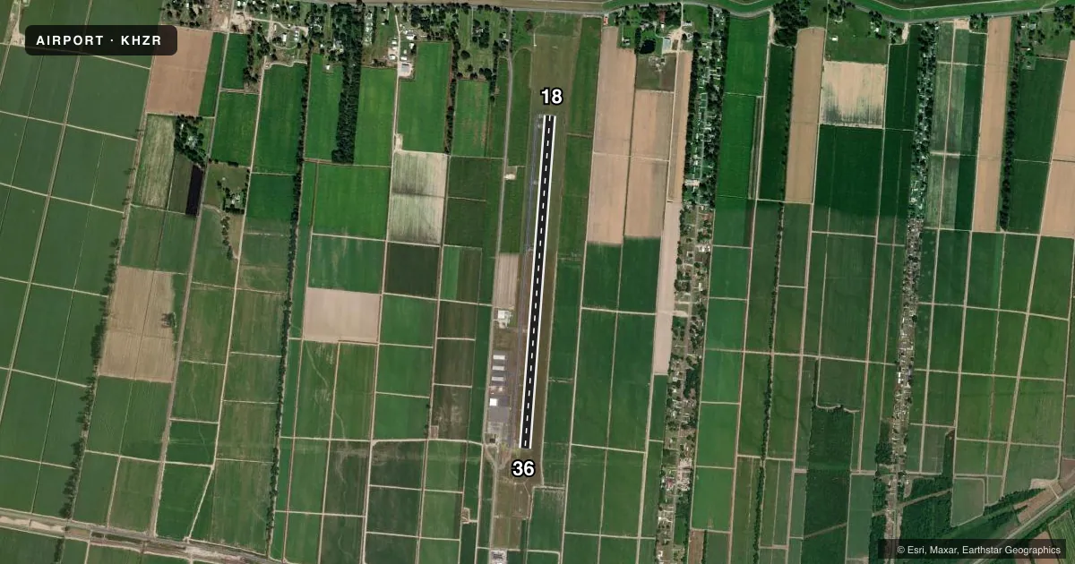
Runways & pattern
Full pagePattern entry · RWY 18
LEFT TRAFFICRunway end performance
| End | TORA | TODA | ASDA | LDA | VGSI | Approach lights | Obstruction |
|---|---|---|---|---|---|---|---|
| 18 | — | — | — | — | PAPI 2-box left(3°) | — | 75', trees, 2445' from thr, 0' R of cntrln, slope 29 |
| 36 | — | — | — | — | PAPI 2-box left(3°) | ODALS | — |
Declared distances in feet. TORA = takeoff run available, TODA = takeoff distance, ASDA = accelerate-stop, LDA = landing distance.
Airport sketch
Runways drawn to scale from FAA survey coordinates, rendered over satellite imagery. Not for navigation.
Approaches & charts
ILS · 1
Services on the field
Fuel grades, oxygen, maintenance, ramp storage and lighting — as declared to the FAA by the airport operator.
Fuel & services
- Fuel
- 100LL
- Oxygen (bottled)
- Not available
- Oxygen (bulk)
- Not available
- Airframe repair
- Not available
- Power plant repair
- Not available
- Other services
- AGRI,INSTR
Ramp & ground
- Transient storage
- Tie-down
- Landing fee
- No fee published
- Customs
- Not available
- Lighting schedule
- SEE RMK
- Beacon schedule
- SS-SR
- Beacon
- White / Green (civil land)(WG)
- Wind indicator
- Lighted
- Segmented circle
- No
Fuel & FBOs
Cheapest 100LL and Jet A on the field and nearby. Always confirm with the FBO before taxi.
Airport notes
Surface conditions, obstructions, local procedures, lighting outages and other notes published with each FAA cycle.
General notes
- DUAL LIGHTING SYSTEM OPERATIONS IN EFFECT DUE TO TESTING OF LED MIRL & TWY LGTS INDEFLY.
- FOR CD CTC HOUSTON ARTCC AT 281-230-5622.
- PUB PRKG PLS CTC AMGR AT 504-273-9018
Lighting notes
- ACTVT REIL RWY 18 - 122.8. MIRL RWY 18/36; ODALS RWY 36 PRESET LOW INTST, TO INCR INTST - 122.8
Fuel notes
- 100LLFUEL AVBL 24 HRS SELF SERVICE WITH CREDIT CARD.
Other notes
- TPA: 260 FT AGL ULTRA-LGT, 460 FT AGL HEL, 960 FT AGL FIXED WING WI 3 NM OF ARPT.
- 1FOR ATTENDANT AFT HRS CALL 504-273-9018.
- 18/36RSCD NOT RPRTED 2100-1300 M-F AND 0500-0459 ON WKENDS, HOLS.
VFR map & nearby airports
VFR sectional. Tap any ICAO chip to open that airport.
Key facts · KHZR
Answer card- ICAO
- KHZR
- Name
- FALSE RIVER RGNL
- Location
- NEW ROADS, LOUISIANA
- Elevation
- 39.1 ft MSL
- Traffic pattern altitude
- 299.1 ft MSL (260 AGL)
- Control tower
- Non-towered (use CTAF)
- Total runways
- 1
- Longest runway
- 18/36 · 5,003 ft
- Published ILS approaches
- 1
- Published frequencies
- 4
- Magnetic variation
- 0°
- Current flight rules
- VFR
- Current wind
- 000° at 0 kt
- Favored runway now
- –
False River Rgnl sits in New Roads, Louisiana. Field elevation is 39.1 ft MSL. The airport has one runway. Runway 18/36 is 5,003 ft long with asphalt pavement. The field is not towered. Pattern altitude is 299.1 ft MSL, which is 260 ft AGL for ultralights. Helicopters use 460 ft AGL. Fixed-wing aircraft within 3 NM use 960 ft AGL.
There is 1 ILS approach. It is for runway 36. The airport also has CTAF and UNICOM on 122.8. Baton Rouge approach and departure are on 120.3 and 278.3. The on-field FBO is False River Regional Airport. It carries 100LL. Fuel is available 24 hours self-service with credit card. If you need an attendant after hours, call the airport number in the Chart Supplement.
First-time pilots should pay attention to the published lighting notes. The airport has a dual lighting system in use because LED runway and taxiway light testing is ongoing. Runway 18 has REILs on 122.8. Runway 36 uses a low-intensity preset on the omnidirectional approach lighting system. Use 122.8 to increase intensity if needed. Runway surface condition is not reported during the published blackout periods. Check current field status before you go.