METAR & TAF KMKV
Current METAR
Observed 06:15Z
KMKV 270615Z AUTO 22004KT 9SM CLR 27/25 A2999 RMK AO2 T02660252
- Wind
- 220° @ 4 kt
- Visibility
- 9 SM
- Temp / Dew
- 27°C / 25°C
- Altimeter
- 29.99 inHg
- Clouds
- CLR
- Density alt
- 1,450 ft
- Ceiling
- Unlimited
- Rules
- VFR
Airport info & contacts
Manager on record, flight service, ARTCC, attendance schedule and pattern altitude — published by the FAA and refreshed every 28 days.
Location
- From city
- 1 NM S
- VFR sectional
- HOUSTON
- ARTCC
- ZHU · HOUSTON
- NOTAM facility
- MKV (NOTAM-D)
Airport manager
- Name
- BRAIN ST. ROMAIN
- Phone
- 318-240-3088
- Address
- 312 NORTH MAIN ST, MARKSVILLE LA 71351
Flight service · Hours
- FSS DRI
- DE RIDDER1-800-WX-BRIEF
- Attendance
- MON-FRI · 0700-1400
Frequencies
Tap any row to copy the frequency to your clipboard.
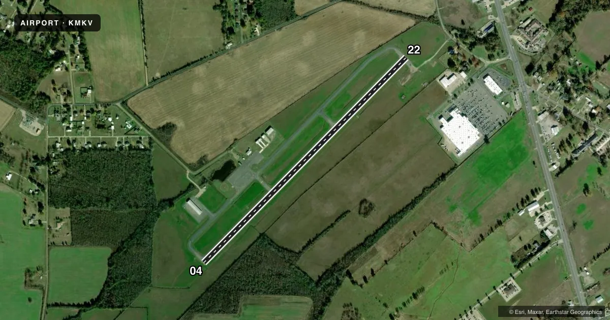
Runways & pattern
Full pagePattern entry · RWY 22
LEFT TRAFFICRunway end performance
| End | TORA | TODA | ASDA | LDA | VGSI | Approach lights | Obstruction |
|---|---|---|---|---|---|---|---|
| 04 | — | — | — | — | PAPI 2-box left(3°) | — | — |
| 22 | — | — | — | — | PAPI 2-box left(3°) | — | 23', pole, 671' from thr, 58' R of cntrln, slope 20 |
Declared distances in feet. TORA = takeoff run available, TODA = takeoff distance, ASDA = accelerate-stop, LDA = landing distance.
Airport sketch
Runways drawn to scale from FAA survey coordinates, rendered over satellite imagery. Not for navigation.
Approaches & charts
Services on the field
Fuel grades, oxygen, maintenance, ramp storage and lighting — as declared to the FAA by the airport operator.
Fuel & services
- Fuel
- 100LL
- Oxygen (bottled)
- Not available
- Oxygen (bulk)
- Not available
- Airframe repair
- Not available
- Power plant repair
- Not available
- Other services
- AGRI
Ramp & ground
- Transient storage
- Tie-down
- Landing fee
- No fee published
- Customs
- Not available
- Lighting schedule
- SEE RMK
- Beacon schedule
- SS-SR
- Beacon
- White / Green (civil land)(WG)
- Wind indicator
- Lighted
- Segmented circle
- Yes
Fuel & FBOs
Cheapest 100LL and Jet A on the field and nearby. Always confirm with the FBO before taxi.
Airport notes
Surface conditions, obstructions, local procedures, lighting outages and other notes published with each FAA cycle.
General notes
- NE APN PAVEMENT FAILED.
- AERIAL SPRAYING INVOF ARPT.
- NE APN HLDG PSN NSTD.
- FOR CD CTC MAKS APCH AT 726-780-0456.
- CTC ARPT MGR FOR DSNGD RAMP SPACE FOR PUB USE AT ARPT
Lighting notes
- ACTVT REIL RWY 4 & 22; MIRL RWY 04/22 PRESET LOW INTST; TO INCR INTST - CTAF.
Fuel notes
- 100LLFUEL AVBL 24/7 WITH CC.
Other notes
- PRE-DATES THE ACT.
VFR map & nearby airports
VFR sectional. Tap any ICAO chip to open that airport.
Key facts · KMKV
Answer card- ICAO
- KMKV
- Name
- MARKSVILLE MUNI
- Location
- MARKSVILLE, LOUISIANA
- Elevation
- 78.3 ft MSL
- Traffic pattern altitude
- 1,078.3 ft MSL (1,000 AGL)
- Control tower
- Non-towered (use CTAF)
- Total runways
- 1
- Longest runway
- 04/22 · 3,799 ft
- Published ILS approaches
- 0
- Published frequencies
- 3
- Magnetic variation
- 2°
- Current flight rules
- VFR
- Current wind
- 220° at 4 kt
- Favored runway now
- RWY 22
Marksville Muni sits in Marksville, Louisiana. Field elevation is 78.3 ft MSL. The airport has one runway, 04/22, at 3,799 ft. There is no control tower. No ILS approaches are published. Pattern altitude is not published, so use the standard 1,000 ft AGL for light piston traffic unless the current Chart Supplement says otherwise.
The on-field FBO is Marksville Municipal Airport. It carries AVGAS 100LL. Fuel is available 24 hours a day with credit card. Call the airport operator or the FBO directly if you need ramp space. The Chart Supplement remarks also note that the northeast apron has a nonstandard holding position and failed pavement. That is worth checking before you taxi in.
For radio work, CTAF is 122.9. Marksville Approach uses 125.4 and 302.2 for clearance and approach or departure work. Runway end identifier lights are active on 04 and 22. The medium intensity runway lights on 04/22 start at low intensity. Use CTAF to increase them if needed. Aerial spraying is reported in the area, so keep a sharp scan on departure and arrival. This is a small non-towered field with light traffic flow. The apron and lighting notes matter the first time you visit.