METAR & TAF L66
L66 does not publish a METAR.
Showing the nearest reporting station: KESF (ESLER RGNL) · 9.8 NM away. Conditions at L66 may differ.
METAR · KESF
Observed 16:53Z
KESF 261653Z AUTO 26007KT 10SM CLR 32/23 A3005 RMK AO2 SLP175 T03220233
- Wind
- 260° @ 7 kt
- Visibility
- 10 SM
- Temp / Dew
- 32°C / 23°C
- Altimeter
- 30.05 inHg
- Clouds
- CLR
- Density alt
- 2,131 ft
- Ceiling
- Unlimited
- Rules
- VFR
Airport info & contacts
Manager on record, flight service, ARTCC, attendance schedule and pattern altitude — published by the FAA and refreshed every 28 days.
Location
- From city
- 4 NM SW
- VFR sectional
- HOUSTON
- ARTCC
- ZHU · HOUSTON
- NOTAM facility
- DRI (NOTAM-D)
Airport manager
- Name
- JOE BECK
- Phone
- 318-623-2436
- Address
- P. O. BOX 1, POLLOCK LA 71467
Flight service · Hours
- FSS DRI
- DE RIDDER1-800-WX-BRIEF
- Attendance
- Unattended
Frequencies
Tap any row to copy the frequency to your clipboard.
Runways & pattern
Full pagePattern entry · RWY 18
LEFT TRAFFICRunway end performance
| End | TORA | TODA | ASDA | LDA | VGSI | Approach lights | Obstruction |
|---|---|---|---|---|---|---|---|
| 18 | — | — | — | — | — | — | 82', trees, 1428' from thr, 124' R of cntrln, slope 14 |
| 36 | — | — | — | — | — | — | 56', trees, 1075' from thr, 168' R of cntrln, slope 15 |
Declared distances in feet. TORA = takeoff run available, TODA = takeoff distance, ASDA = accelerate-stop, LDA = landing distance.
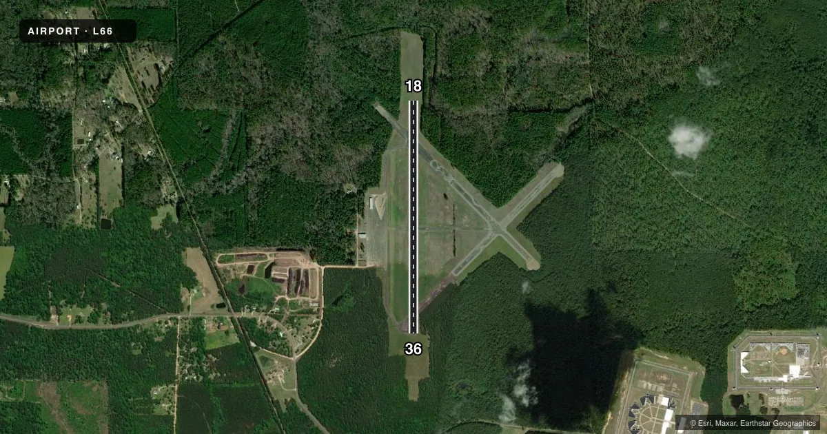
Airport sketch
Runways drawn to scale from FAA survey coordinates, rendered over satellite imagery. Not for navigation.
Approaches & charts
Services on the field
Fuel grades, oxygen, maintenance, ramp storage and lighting — as declared to the FAA by the airport operator.
Fuel & services
- Fuel
- Not available
- Oxygen (bottled)
- Not available
- Oxygen (bulk)
- Not available
- Other services
- INSTR
Ramp & ground
- Transient storage
- Tie-down
- Hangar
- Landing fee
- No fee published
- Customs
- Not available
- Lighting schedule
- SEE RMK
- Beacon schedule
- SS-SR
- Beacon
- White / Green (civil land)(WG)
- Wind indicator
- Lighted
- Segmented circle
- No
Fuel & FBOs
Cheapest 100LL and Jet A on the field and nearby. Always confirm with the FBO before taxi.
Airport notes
Surface conditions, obstructions, local procedures, lighting outages and other notes published with each FAA cycle.
General notes
- RY 18/36 30 FT TREES BOTH SIDES OF RY PENETRATE TRANSITION SLOPE.
- FOR CD CTC MAKS APCH AT 726-780-0456.
- CTC APRT MGR FOR DSGND RAMP SPACE FOR PUB USE.
Lighting notes
- ROTG BCN LCTD 1/2 MI SE OF AIRPORT. ROTG BCN OTS INDEFLY.
- MIRL RY 18/36 PRESET LOW INTST; TO INCR INTST ACTVT - 122.7.
Runway surface & condition
- 18/36NORTH 1000 FT OF RY CLSD INDEFLY.
Approach & departure obstructions
- 18RY MARKINGS FADED.
- 36RY MARKINGS FADED.
Other notes
- THIS AIRPORT HAS BEEN SURVEYED BY THE NATIONAL GEODETIC SURVEY.
- PREDATES THE ACT.
- 18/36RY CRACKING AND GRASS GROWING THRU CRACKS. CRACKS IN RY GREATER THAN 1/4 INCH. SURFACE ROUGH. PONDING/STANDING WATER ON RY NEAR RYS 18 & 36 APCH END. RY SURFACE DISINTEGRATING.
VFR map & nearby airports
VFR sectional. Tap any ICAO chip to open that airport.
Key facts · L66
Answer card- ICAO
- L66
- Name
- POLLOCK MUNI
- Location
- POLLOCK, LOUISIANA
- Elevation
- 203 ft MSL
- Traffic pattern altitude
- 1,203 ft MSL (1,000 AGL)
- Control tower
- Non-towered (use CTAF)
- Total runways
- 1
- Longest runway
- 18/36 · 4,499 ft
- Published ILS approaches
- 0
- Published frequencies
- 1
- Magnetic variation
- 4°
- Current flight rules
- VFR
- Current wind
- 260° at 7 kt
- Favored runway now
- RWY 18
Pollock Muni sits in Pollock, Louisiana. Field elevation is 203 ft MSL. The airport has one runway, 18/36, which is 4,499 ft long and paved asphalt. There is no control tower, so CTAF is the main traffic frequency at 122.9. No ILS approaches are published here.
The pattern altitude is not published. Use the standard 1,000 ft AGL for light piston operations unless the current Chart Supplement says otherwise. For this field that works out to about 1,203 ft MSL. The published remarks matter here. The north 1,000 ft of runway 18/36 is closed indefinitely. The runway surface is rough, with cracking, grass through the cracks, ponding near both ends and faded markings on both runway ends. Trees on both sides also penetrate the transition slope. The rotating beacon is out of service indefinitely.
There are no on-field FBOs listed. Contact the airport manager for ramp space before arrival. If you need clearance delivery, contact MAKS Approach at 726-780-0456. First-time pilots should plan for a non-towered field with runway condition issues, limited visual cues at night and a runway that is not in normal full-length service. Check the current FAA Chart Supplement before you go.