METAR & TAF 0R5
0R5 does not publish a METAR.
Showing the nearest reporting station: KIER (NATCHITOCHES RGNL) · 26.2 NM away. Conditions at 0R5 may differ.
METAR · KIER
Observed 12:15Z
KIER 261215Z AUTO 00000KT 10SM CLR 24/24 A3008 RMK AO2 T02350235
- Wind
- 000° @ 0 kt
- Visibility
- 10 SM
- Temp / Dew
- 24°C / 24°C
- Altimeter
- 30.08 inHg
- Clouds
- CLR
- Density alt
- 1,063 ft
- Ceiling
- Unlimited
- Rules
- VFR
Airport info & contacts
Manager on record, flight service, ARTCC, attendance schedule and pattern altitude — published by the FAA and refreshed every 28 days.
Location
- From city
- 3 NM NW
- VFR sectional
- HOUSTON
- ARTCC
- ZHU · HOUSTON
- NOTAM facility
- DRI (NOTAM-D)
Airport manager
- Name
- AUNDRA BASS
- Phone
- (318) 628-3939
- Address
- PO BOX 509, WINNFIELD LA 71483
Flight service · Hours
- FSS DRI
- DE RIDDER1-800-WX-BRIEF
- Attendance
- Unattended
Frequencies
Tap any row to copy the frequency to your clipboard.
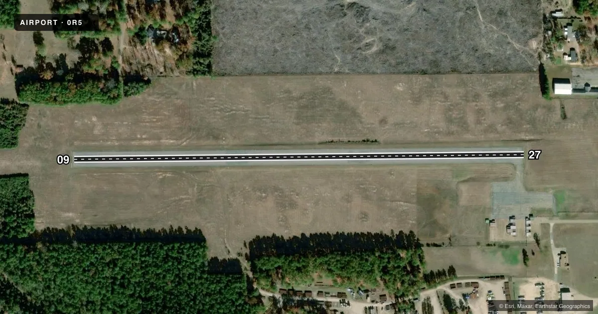
Runways & pattern
Full pagePattern entry · RWY 09
LEFT TRAFFICRunway end performance
| End | TORA | TODA | ASDA | LDA | VGSI | Approach lights | Obstruction |
|---|---|---|---|---|---|---|---|
| 09 | — | — | — | — | PAPI 2-box left(3°) | — | 101', trees, 3043' from thr, 159' R of cntrln, slope 28 |
| 27 | — | — | — | — | PAPI 2-box left(3.45°) | — | 77', trees, 937' from thr, 178' R of cntrln, slope 9 |
Declared distances in feet. TORA = takeoff run available, TODA = takeoff distance, ASDA = accelerate-stop, LDA = landing distance.
Airport sketch
Runways drawn to scale from FAA survey coordinates, rendered over satellite imagery. Not for navigation.
Approaches & charts
Services on the field
Fuel grades, oxygen, maintenance, ramp storage and lighting — as declared to the FAA by the airport operator.
Fuel & services
- Fuel
- Not available
- Oxygen (bottled)
- Not available
- Oxygen (bulk)
- Not available
- Airframe repair
- Not available
- Power plant repair
- Not available
- Other services
- AGRI
Ramp & ground
- Transient storage
- Tie-down
- Landing fee
- No fee published
- Customs
- Not available
- Lighting schedule
- SEE RMK
- Beacon schedule
- SS-SR
- Beacon
- White / Green (civil land)(WG)
- Wind indicator
- Yes
- Segmented circle
- No
Fuel & FBOs
Cheapest 100LL and Jet A on the field and nearby. Always confirm with the FBO before taxi.
Airport notes
Surface conditions, obstructions, local procedures, lighting outages and other notes published with each FAA cycle.
General notes
- FOR CD CTC MAKS APCH AT 726-780-0456.
- CTC APRT MGR FOR DSGND RAMP SPACE FOR PUB USE.
Lighting notes
- ROTG BCN OBSCURED BY TREES SOUTH, WEST AND EAST.
- MIRL RWY 09/27 OPR SS-SR AND PRESET LOW INTST; TO INCR INTST AND ACTVT REIL RWY 09 AND 27 - CTAF.
Other notes
- THIS AIRPORT HAS BEEN SURVEYED BY THE NATIONAL GEODETIC SURVEY.
- PREDATES ACT.
VFR map & nearby airports
VFR sectional. Tap any ICAO chip to open that airport.
Key facts · 0R5
Answer card- ICAO
- 0R5
- Name
- DAVID G JOYCE
- Location
- WINNFIELD, LOUISIANA
- Elevation
- 146 ft MSL
- Traffic pattern altitude
- 1,146 ft MSL (1,000 AGL)
- Control tower
- Non-towered (use CTAF)
- Total runways
- 1
- Longest runway
- 09/27 · 3,002 ft
- Published ILS approaches
- 0
- Published frequencies
- 4
- Magnetic variation
- 2°
- Current flight rules
- VFR
- Current wind
- 000° at 0 kt
- Favored runway now
- –
David G Joyce (0R5) is in Winnfield, Louisiana. The field elevation is 146 ft MSL. It has one runway. Runway 09/27 is 3,002 ft long and asphalt. No control tower is published. Pattern altitude is not published, so a light piston pilot should plan on the standard 1,000 ft AGL unless the current Chart Supplement says otherwise.
No ILS approaches are published here. Clearance delivery is handled by MAKS Approach at 726-780-0456. CTAF and UNICOM are both 122.7. The published remarks matter here. The runway lights on 09/27 operate from sunset to sunrise. They are preset to low intensity. Use the CTAF to increase intensity. Use it to activate the runway end identifier lights. The rotating beacon is obscured by trees to the south, west and east. Contact the airport manager for designated ramp space before you go.
There are no on-field FBOs listed in the facts. Plan on checking with the airport operator or the FBO directly by phone for current services before arrival. For a first-time visit, the main things to brief are the single short runway, the lack of published ILS and the need to sort out ramp space ahead of time.