METAR & TAF F86
F86 does not publish a METAR.
Showing the nearest reporting station: KMLU (MONROE RGNL) · 23.3 NM away. Conditions at F86 may differ.
METAR · KMLU
Observed 10:53Z
KMLU 271053Z 20003KT 10SM CLR 26/23 A2996 RMK AO2 SLP145 T02560228
- Wind
- 200° @ 3 kt
- Visibility
- 10 SM
- Temp / Dew
- 26°C / 23°C
- Altimeter
- 29.96 inHg
- Clouds
- CLR
- Density alt
- 1,353 ft
- Ceiling
- Unlimited
- Rules
- VFR
Airport info & contacts
Manager on record, flight service, ARTCC, attendance schedule and pattern altitude — published by the FAA and refreshed every 28 days.
Location
- From city
- 2 NM NE
- VFR sectional
- MEMPHIS
- ARTCC
- ZFW · FORT WORTH
- NOTAM facility
- DRI (NOTAM-D)
Airport manager
- Name
- REED KEAHEY
- Phone
- (318) 331-3888
- Address
- PO BOX 1139, COLUMBIA LA 71418
Flight service · Hours
- FSS DRI
- DE RIDDER1-800-WX-BRIEF
- Attendance
- Unattended
Frequencies
Tap any row to copy the frequency to your clipboard.
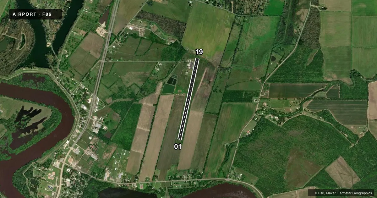
Runways & pattern
Full pagePattern entry · RWY 19
LEFT TRAFFICRunway end performance
| End | TORA | TODA | ASDA | LDA | VGSI | Approach lights | Obstruction |
|---|---|---|---|---|---|---|---|
| 01 | — | — | — | — | PAPI 2-box left(3.5°) | — | 81', trees, 1580' from thr, 151' R of cntrln, slope 17 |
| 19 | — | — | — | — | PAPI 2-box left(3°) | — | — |
Declared distances in feet. TORA = takeoff run available, TODA = takeoff distance, ASDA = accelerate-stop, LDA = landing distance.
Airport sketch
Runways drawn to scale from FAA survey coordinates, rendered over satellite imagery. Not for navigation.
Approaches & charts
Services on the field
Fuel grades, oxygen, maintenance, ramp storage and lighting — as declared to the FAA by the airport operator.
Fuel & services
- Fuel
- Not available
- Oxygen (bottled)
- Not available
- Oxygen (bulk)
- Not available
- Airframe repair
- Not available
- Power plant repair
- Not available
- Other services
- AGRI
Ramp & ground
- Transient storage
- Tie-down
- Landing fee
- No fee published
- Customs
- Not available
- Lighting schedule
- SEE RMK
- Beacon schedule
- SS-SR
- Beacon
- White / Green (civil land)(WG)
- Wind indicator
- Lighted
- Segmented circle
- Yes
Fuel & FBOs
Cheapest 100LL and Jet A on the field and nearby. Always confirm with the FBO before taxi.
Airport notes
Surface conditions, obstructions, local procedures, lighting outages and other notes published with each FAA cycle.
General notes
- BIRDS IN VCNTY OF AP.
- FOREIGN OBJECTS & DEBRIS PRESENT ON APRON. GRASS GROWING THROUGH CRACKS.
- FOR CD CTC MONROE APCH AT 318-327-5641, IF UNAVBL, CTC FORT WORTH ARTCC AT 817-858-7584.
- CTC APRT MNGR FOR DSGND RAMP SPACE FOR PUB USE.
Lighting notes
- REIL RWY 01/19 OPR CONS; ACTVT MIRL RWY 01/19 - CTAF.
Runway surface & condition
- 01/19RWY LIGHTS - OTS INDEF.
Approach & departure obstructions
- 014 FT FENCE 197 FT FM END OF RWY.
- 01REIL OTS APCH END RWY 01.
- 19REIL OTS APCH END RWY 19.
- 19RWY 19 PAPI - OTS
Other notes
- THIS AIRPORT HAS BEEN SURVEYED BY THE NATIONAL GEODETIC SURVEY.
- WINDSOCK OTS TEMPOLY.
- 01/19GRASS GROWING THROUGH CRACKS.
VFR map & nearby airports
VFR sectional. Tap any ICAO chip to open that airport.
Key facts · F86
Answer card- ICAO
- F86
- Name
- CALDWELL PARISH
- Location
- COLUMBIA, LOUISIANA
- Elevation
- 66.9 ft MSL
- Traffic pattern altitude
- 1,066.9 ft MSL (1,000 AGL)
- Control tower
- Non-towered (use CTAF)
- Total runways
- 1
- Longest runway
- 01/19 · 3,501 ft
- Published ILS approaches
- 0
- Published frequencies
- 1
- Magnetic variation
- 4°
- Current flight rules
- VFR
- Current wind
- 200° at 3 kt
- Favored runway now
- RWY 19
Caldwell Parish Airport (F86) sits near Columbia, Louisiana. Field elevation is 66.9 ft MSL. The airport has one runway. Runway 01/19 is 3,501 ft asphalt, which is the longest runway on the field. There is no control tower. CTAF is 122.9.
No ILS approaches are published here. Pattern altitude is not published, so use the standard 1,000 ft AGL for light piston operations unless the current Chart Supplement says otherwise. The published remarks matter here. Birds are reported in the area. Foreign objects and debris are present on the apron. Grass is growing through cracks on the runway and apron surfaces. The windsock is temporarily out of service. Runway lights are also out of service indefinitely, even though runway end identifier lights are noted as operating continuously with medium intensity lights activated on CTAF. Runway 19 PAPI is out of service. Runway 01 has a fence 197 ft from the end of the runway. Clearance delivery is handled through Monroe Approach at 318-327-5641. If that is unavailable, contact Fort Worth ARTCC at 817-858-7584. There are no on-field FBOs listed, so verify services with the airport operator or call the field directly before arrival.