METAR & TAF KRSN
Current METAR
Observed 13:35Z
KRSN 271335Z AUTO VRB04KT 10SM CLR 28/26 A3000 RMK AO2 T02760261 $
- Wind
- VAR @ 4 kt
- Visibility
- 10 SM
- Temp / Dew
- 28°C / 26°C
- Altimeter
- 30.00 inHg
- Clouds
- CLR
- Density alt
- 1,854 ft
- Ceiling
- Unlimited
- Rules
- VFR
Airport info & contacts
Manager on record, flight service, ARTCC, attendance schedule and pattern altitude — published by the FAA and refreshed every 28 days.
Location
- From city
- 3 NM E
- VFR sectional
- MEMPHIS
- Pattern altitude
- 1,000 ft AGL · 1,317 ft MSL
- ARTCC
- ZFW · FORT WORTH
- NOTAM facility
- RSN (NOTAM-D)
Airport manager
- Name
- JOHN FREEMAN
- Phone
- 318-242-7703
- Address
- 701 E. TENNESSEE AVE, PO BOX 2069, RUSTON LA 71270
Flight service · Hours
- FSS DRI
- DE RIDDER1-800-WX-BRIEF
- Attendance
- 0700-1900
Frequencies
Tap any row to copy the frequency to your clipboard.
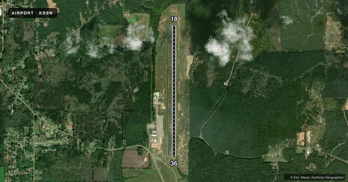
Runways & pattern
Full pagePattern entry · RWY 36
LEFT TRAFFICRunway end performance
| End | TORA | TODA | ASDA | LDA | VGSI | Approach lights | Obstruction |
|---|---|---|---|---|---|---|---|
| 18 | — | — | — | — | PAPI 4-box left(3°) | — | 60', trees, 2383' from thr, 450' R of cntrln, slope 36 |
| 36 | — | — | — | — | PAPI 4-box left(3°) | — | — |
Declared distances in feet. TORA = takeoff run available, TODA = takeoff distance, ASDA = accelerate-stop, LDA = landing distance.
Airport sketch
Runways drawn to scale from FAA survey coordinates, rendered over satellite imagery. Not for navigation.
Approaches & charts
Services on the field
Fuel grades, oxygen, maintenance, ramp storage and lighting — as declared to the FAA by the airport operator.
Fuel & services
- Fuel
- 100LLA
- Oxygen (bottled)
- Not available
- Oxygen (bulk)
- Not available
- Airframe repair
- Minor
- Power plant repair
- Minor
- Other services
- CHTR,INSTR,RNTL,SALES
Ramp & ground
- Transient storage
- Tie-down
- Hangar
- Lighting schedule
- SEE RMK
- Beacon schedule
- SS-SR
- Beacon
- White / Green (civil land)(WG)
- Wind indicator
- Lighted
- Segmented circle
- Yes
Fuel & FBOs
Cheapest 100LL and Jet A on the field and nearby. Always confirm with the FBO before taxi.
Airport notes
Surface conditions, obstructions, local procedures, lighting outages and other notes published with each FAA cycle.
General notes
- NUMEROUS TRNG ACFT IN VICINITY.
- MEN AND EQUIPMENT OPERATING NEAR THE RUNWAY MARCH-OCTOBER
- FOR CD CTC MONROE APCH AT 318-327-5641 OR 118.8, IF UNAVBL, CTC FORT WORTH ARTCC AT 817-858-7584
- ADDTL AIRPORT MANAGER CONTACT - JOEY SUTTON OFFICE # 318-251-9098 | MOBILE # 318-265-1415
- CTC ARPT MGR FOR DSNGD RAMP SPACE FOR PU USE AT ARPT
Lighting notes
- REIL RWY 18 & 36; MIRL RWY 18/36 - PRESET LOW INTST DUSK-DAWN; TO INCR INTST ACTVT - CTAF.
Fuel notes
- 100LLFOR FUEL AFTER HOURS CALL IN ADVANCE DURING WORKING HOURS 318-251-9098.
Other notes
- PRVDD ALL CONDITIONS LISTED IN THE 2/10/94 LTR ARE ADHERED TO.
- MANAGERDIRECTOR OF PUBLIC WORKS
VFR map & nearby airports
VFR sectional. Tap any ICAO chip to open that airport.
Key facts · KRSN
Answer card- ICAO
- KRSN
- Name
- RUSTON RGNL
- Location
- RUSTON, LOUISIANA
- Elevation
- 316.8 ft MSL
- Traffic pattern altitude
- 1,316.8 ft MSL (1,000 AGL)
- Control tower
- Non-towered (use CTAF)
- Total runways
- 1
- Longest runway
- 18/36 · 6,002 ft
- Published ILS approaches
- 0
- Published frequencies
- 5
- Magnetic variation
- 3°
- Current flight rules
- VFR
- Current wind
- 000° at 4 kt
- Favored runway now
- RWY 36
Ruston Rgnl is in Ruston, Louisiana. The field elevation is 316.8 ft MSL. It has one runway, 18/36, which is 6,002 ft long with asphalt pavement. There is no control tower. Pattern altitude is 1,000 ft AGL. That puts the pattern at 1,316.8 ft MSL.
No ILS approaches are published here. The airport uses CTAF 122.7. Clearance delivery can be handled through Monroe Approach on 118.8. The published Monroe frequencies can also be used if needed. Ruston Aviation is the on-field FBO. It carries 100LL, Jet A and Jet A Prist. If you need 100LL after hours, call ahead during working hours.
A first-time arrival should pay attention to the local traffic picture. The remarks note numerous training aircraft in the area. Men and equipment also operate near the runway from March through October. Runway end identifier lights are installed on 18 and 36. The runway lights are medium intensity. They default to low intensity from dusk to dawn. Use the CTAF to increase intensity if needed. The airport sits in north Louisiana, so check current weather, runway condition and traffic before you go. If you need ramp space for pick-up use, contact the airport manager before arrival.