METAR & TAF KMNE
Current METAR
Observed 06:15Z
KMNE 270615Z AUTO 00000KT 10SM CLR 25/22 A2997 RMK AO2
- Wind
- 000° @ 0 kt
- Visibility
- 10 SM
- Temp / Dew
- 25°C / 22°C
- Altimeter
- 29.97 inHg
- Clouds
- CLR
- Density alt
- 1,483 ft
- Ceiling
- Unlimited
- Rules
- VFR
Airport info & contacts
Manager on record, flight service, ARTCC, attendance schedule and pattern altitude — published by the FAA and refreshed every 28 days.
Location
- From city
- 2 NM NW
- VFR sectional
- MEMPHIS
- Pattern altitude
- 1,022 ft AGL · 1,300 ft MSL
- ARTCC
- ZFW · FORT WORTH
- NOTAM facility
- FTW (NOTAM-D)
Airport manager
- Name
- MOLLY FOWLER
- Phone
- 318-371-7862
- Address
- 100 AVIATION DRIVE, MINDEN LA 71055
Flight service · Hours
- FSS FTW
- FORT WORTH1-800-WX-BRIEF
- Attendance
- 0800-1800
Frequencies
Tap any row to copy the frequency to your clipboard.
Runways & pattern
Full pagePattern entry · RWY 01
LEFT TRAFFICRunway end performance
| End | TORA | TODA | ASDA | LDA | VGSI | Approach lights | Obstruction |
|---|---|---|---|---|---|---|---|
| 01 | — | — | — | — | PAPI 2-box left(3.15°) | — | 53', trees, 1583' from thr, 317' R of cntrln, slope 26 |
| 19 | — | — | — | — | PAPI 2-box left(3.75°) | — | 28', trees, 291' from thr, 127' R of cntrln, slope 3 |
Declared distances in feet. TORA = takeoff run available, TODA = takeoff distance, ASDA = accelerate-stop, LDA = landing distance.
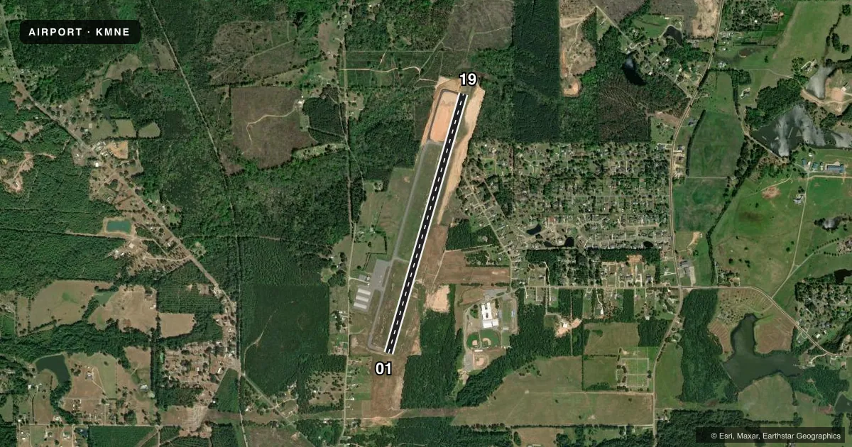
Airport sketch
Runways drawn to scale from FAA survey coordinates, rendered over satellite imagery. Not for navigation.
Approaches & charts
Services on the field
Fuel grades, oxygen, maintenance, ramp storage and lighting — as declared to the FAA by the airport operator.
Fuel & services
- Fuel
- 100LLA+
- Oxygen (bottled)
- Not available
- Oxygen (bulk)
- Not available
- Other services
- INSTR
Ramp & ground
- Transient storage
- Tie-down
- Hangar
- Landing fee
- No fee published
- Customs
- Not available
- Lighting schedule
- SEE RMK
- Beacon schedule
- SS-SR
- Beacon
- White / Green (civil land)(WG)
- Wind indicator
- Lighted
- Segmented circle
- No
Fuel & FBOs
Cheapest 100LL and Jet A on the field and nearby. Always confirm with the FBO before taxi.
Airport notes
Surface conditions, obstructions, local procedures, lighting outages and other notes published with each FAA cycle.
General notes
- GCO AVBL ON FREQ 135.075 THRU BAD RAPCON.
- BIRDS ON & INVOF ARPT.
- FOR CD IF UNA VIA GCO CTC FORT WORTH ARTCC AT 817-858-7584.
- CTC ARPT MGR FOR DSNGD RAMP SPACE FOR PUB USE AT ARPT
Lighting notes
- ACTVT MIRL RY 01/19 - CTAF.
Other notes
- THIS AIRPORT HAS BEEN SURVEYED BY THE NATIONAL GEODETIC SURVEY.
- 1FOR ARPT ATTENDANT AFT HRS CALL 318-377-2144.
VFR map & nearby airports
VFR sectional. Tap any ICAO chip to open that airport.
Key facts · KMNE
Answer card- ICAO
- KMNE
- Name
- MINDEN
- Location
- MINDEN, LOUISIANA
- Elevation
- 278.4 ft MSL
- Traffic pattern altitude
- 1,300.4 ft MSL (1,022 AGL)
- Control tower
- Non-towered (use CTAF)
- Total runways
- 1
- Longest runway
- 01/19 · 5,004 ft
- Published ILS approaches
- 0
- Published frequencies
- 4
- Magnetic variation
- 4°
- Current flight rules
- VFR
- Current wind
- 000° at 0 kt
- Favored runway now
- –
Minden Airport sits in Minden, Louisiana. Field elevation is 278.4 ft MSL. The airport has one runway. Runway 01/19 is 5,004 ft long and is the longest runway on the field. There is no control tower. The published pattern altitude is 1,022 ft AGL, which is 1,300.4 ft MSL.
No ILS approaches are published here, so plan with the current charted procedures before you go. The field uses CTAF 122.8 and UNICOM 122.8. Runway lights on 01/19 are medium intensity and activate on the CTAF. Published remarks also note a ground communications outlet on 135.075 through BAD RAPCON. Birds are on and near the airport, so keep a sharp scan on arrival and departure.
Minden Airport has one on-field FBO, Minden Airport. It carries 100LL and Jet A with Prist. If you need airport attendant help after hours, the published number is available in the Chart Supplement. For ramp space, contact the airport manager before you arrive. If you are planning a first trip in, verify current procedures with the FAA Chart Supplement and expect non-towered traffic flow with nearby approach control support from Shreveport.