METAR & TAF KSPH
KSPH does not publish a METAR.
Showing the nearest reporting station: KAGO (RALPH C WEISER FLD) · 17.5 NM away. Conditions at KSPH may differ.
METAR · KAGO
Observed 11:35Z
KAGO 271135Z AUTO 20003KT 10SM CLR 23/22 A2995 RMK A01
- Wind
- 200° @ 3 kt
- Visibility
- 10 SM
- Temp / Dew
- 23°C / 22°C
- Altimeter
- 29.95 inHg
- Clouds
- CLR
- Density alt
- 1,193 ft
- Ceiling
- Unlimited
- Rules
- VFR
Airport info & contacts
Manager on record, flight service, ARTCC, attendance schedule and pattern altitude — published by the FAA and refreshed every 28 days.
Location
- From city
- 3 NM E
- VFR sectional
- MEMPHIS
- ARTCC
- ZFW · FORT WORTH
- NOTAM facility
- DRI (NOTAM-D)
Airport manager
- Name
- MOLLY FOWLER
- Phone
- 318-453-5637
- Address
- P.O BOX 398, SPRINGHILL LA 71075
Flight service · Hours
- FSS DRI
- DE RIDDER1-800-WX-BRIEF
- Attendance
- Unattended
Frequencies
Tap any row to copy the frequency to your clipboard.
Runways & pattern
Full pagePattern entry · RWY 18
LEFT TRAFFICRunway end performance
| End | TORA | TODA | ASDA | LDA | VGSI | Approach lights | Obstruction |
|---|---|---|---|---|---|---|---|
| 18 | — | — | — | — | PAPI 2-box left(3°) | — | 95', trees, 2158' from thr, 0' R of cntrln, slope 20 |
| 36 | — | — | — | — | PAPI 2-box left(3°) | — | 90', trees, 2543' from thr, 292' R of cntrln, slope 26 |
Declared distances in feet. TORA = takeoff run available, TODA = takeoff distance, ASDA = accelerate-stop, LDA = landing distance.
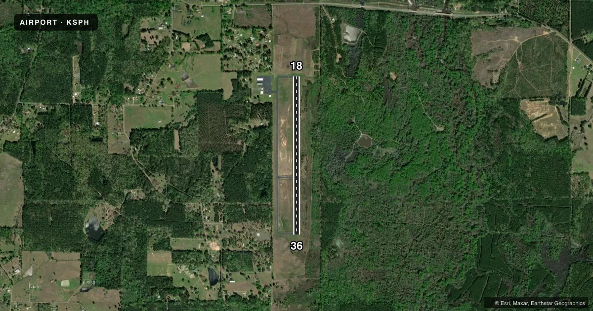
Airport sketch
Runways drawn to scale from FAA survey coordinates, rendered over satellite imagery. Not for navigation.
Approaches & charts
Services on the field
Fuel grades, oxygen, maintenance, ramp storage and lighting — as declared to the FAA by the airport operator.
Fuel & services
- Fuel
- Not available
- Oxygen (bottled)
- Not available
- Oxygen (bulk)
- Not available
- Airframe repair
- Not available
- Power plant repair
- Not available
Ramp & ground
- Transient storage
- Tie-down
- Landing fee
- No fee published
- Customs
- Not available
- Lighting schedule
- SEE RMK
- Beacon schedule
- SS-SR
- Beacon
- White / Green (civil land)(WG)
- Wind indicator
- Lighted
- Segmented circle
- No
Fuel & FBOs
Cheapest 100LL and Jet A on the field and nearby. Always confirm with the FBO before taxi.
Airport notes
Surface conditions, obstructions, local procedures, lighting outages and other notes published with each FAA cycle.
General notes
- FOR CD CTC FORT WORTH ARTCC AT 817-858-7584.
- ULTRALIGHT ACTIVITY ON AND IN VICINITY OF AIRPORT
- CTC APRT MGR FOR DSGND RAMP SPACE FOR PUB USE.
Lighting notes
- AIRPORT BEACON LOCATED .52 MILES FROM THE APPROACH END RWY 18 RIGHT OF CENTERLINE
- MIRL RWY 18/36 PRESET LOW INTST DUSK-DAWN; TO INCR INTST ACTVT - CTAF.
Approach & departure obstructions
- 18PAPI UNUSBL BYD 9 DEGS RIGHT OF CNTRLN.
VFR map & nearby airports
VFR sectional. Tap any ICAO chip to open that airport.
Key facts · KSPH
Answer card- ICAO
- KSPH
- Name
- SPRINGHILL
- Location
- SPRINGHILL, LOUISIANA
- Elevation
- 217.6 ft MSL
- Traffic pattern altitude
- 1,217.6 ft MSL (1,000 AGL)
- Control tower
- Non-towered (use CTAF)
- Total runways
- 1
- Longest runway
- 18/36 · 4,202 ft
- Published ILS approaches
- 0
- Published frequencies
- 4
- Magnetic variation
- 2°
- Current flight rules
- VFR
- Current wind
- 200° at 3 kt
- Favored runway now
- RWY 18
Springhill Airport (KSPH) sits in Springhill, Louisiana. Field elevation is 217.6 ft MSL. The airport has one runway, 18/36, at 4,202 ft asphalt. It is not towered. CTAF and UNICOM are both 122.8. Approach and departure control is with Shreveport on 123.75 or 360.725.
No ILS approaches are published here. Pattern altitude is not published, so use the standard 1,000 ft AGL for light piston traffic unless the current Chart Supplement says otherwise. That puts the traffic pattern at about 1,218 ft MSL based on the listed field elevation.
There are no on-field FBOs listed in the facts. Contact the airport operator directly before arrival for ramp space. The published remarks also note that ultralight activity occurs on and near the airport. That is worth keeping in mind in the pattern. The runway lights on 18/36 are preset to low intensity from dusk to dawn. Use the CTAF to increase intensity if needed. The airport beacon is 0.52 miles from the approach end of runway 18, right of centerline. The PAPI on runway 18 is unusable beyond 9 degrees right of the runway 18 centerline. For clearance delivery, contact Fort Worth ARTCC at 817-858-7584.