METAR & TAF KELD
Current METAR
Observed 14:53Z
KELD 271453Z AUTO 25007KT 10SM CLR 31/24 A3000 RMK AO2 SLP154 T03060239 50007
- Wind
- 250° @ 7 kt
- Visibility
- 10 SM
- Temp / Dew
- 31°C / 24°C
- Altimeter
- 30.00 inHg
- Clouds
- CLR
- Density alt
- 2,164 ft
- Ceiling
- Unlimited
- Rules
- VFR
Airport info & contacts
Manager on record, flight service, ARTCC, attendance schedule and pattern altitude — published by the FAA and refreshed every 28 days.
Location
- From city
- 8 NM W
- VFR sectional
- MEMPHIS
- ARTCC
- ZFW · FORT WORTH
- NOTAM facility
- ELD (NOTAM-D)
Airport manager
- Name
- MICHELLE ANTHONY
- Phone
- 870-881-4192
- Address
- 418 AIRPORT DR., EL DORADO AR 71730
Flight service · Hours
- FSS JBR
- JONESBORO1-800-WX-BRIEF
- Attendance
- MON-FRI · 0600-1730
- SUN · 1030-1730
- SAT · 1030-1730
Frequencies
Tap any row to copy the frequency to your clipboard.
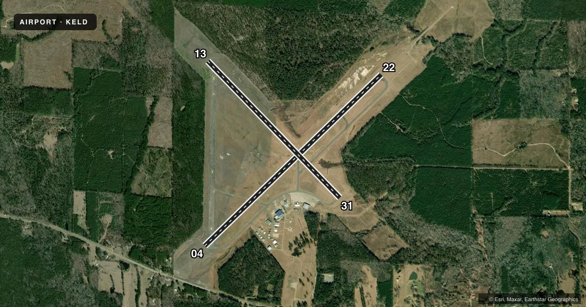
Runways & pattern
Full pagePattern entry · RWY 22
LEFT TRAFFIC| Runway | Heading (°M) | Length | Surface | Traffic |
|---|---|---|---|---|
| 04/22Favored | 43° / 223° | 6,601 ft | ASPH | Standard L |
| 13/31 | 133° / 313° | 5,100 ft | ASPH | Standard L |
Runway end performance
| End | TORA | TODA | ASDA | LDA | VGSI | Approach lights | Obstruction |
|---|---|---|---|---|---|---|---|
| 04 | — | — | — | — | PAPI 4-box left(3°) | — | 40', trees, 1600' from thr, 400' R of cntrln, slope 35 |
| 22 | — | — | — | — | PAPI 4-box left(3°) | MALSR | — |
| 13 | — | — | — | — | PAPI 2-box left(4°) | — | — |
| 31 | — | — | — | — | PAPI 2-box right(4°) | — | — |
Declared distances in feet. TORA = takeoff run available, TODA = takeoff distance, ASDA = accelerate-stop, LDA = landing distance.
Airport sketch
Runways drawn to scale from FAA survey coordinates, rendered over satellite imagery. Not for navigation.
Approaches & charts
ILS · 1
Services on the field
Fuel grades, oxygen, maintenance, ramp storage and lighting — as declared to the FAA by the airport operator.
Fuel & services
- Fuel
- 100LLA+
- Airframe repair
- Major
- Power plant repair
- Major
- Other services
- AMB,INSTR,RNTL
Ramp & ground
- Transient storage
- Tie-down
- Hangar
- Landing fee
- No fee published
- Customs
- Not available
- Lighting schedule
- SEE RMK
- Beacon schedule
- SS-SR
- Beacon
- White / Green (civil land)(WG)
- Wind indicator
- Lighted
- Segmented circle
- No
Fuel & FBOs
Cheapest 100LL and Jet A on the field and nearby. Always confirm with the FBO before taxi.
Airport notes
Surface conditions, obstructions, local procedures, lighting outages and other notes published with each FAA cycle.
General notes
- FOR CD IF UNA TO CTC ON FSS FREQ, CTC FORT WORTH ARTCC AT 817-858-7584.
Lighting notes
- DUSK-DAWN. HIRL RWY 04/22 PRESET LOW INTST; TO INCR INTST & ACTVT MALSR RWY 22; MIRL RWY 13/31; TWY LGTS - CTAF.
Approach & departure obstructions
- 13PAPI UNUSBL BYD 9 DEGS LEFT AND 6 DEGS RIGHT OF CNTRLN.
- 31PAPI UNUSBL BYD 7 DEGS LEFT AND RIGHT OF CNTRLN.
Other notes
- 1FOR SVC AFT HRS CALL 870-866-9696; FEE CHRGD.
VFR map & nearby airports
VFR sectional. Tap any ICAO chip to open that airport.
Key facts · KELD
Answer card- ICAO
- KELD
- Name
- SOUTH ARKANSAS RGNL AT GOODWIN FLD
- Location
- EL DORADO, ARKANSAS
- Elevation
- 277.1 ft MSL
- Traffic pattern altitude
- 1,277.1 ft MSL (1,000 AGL)
- Control tower
- Non-towered (use CTAF)
- Total runways
- 2
- Longest runway
- 04/22 · 6,601 ft
- Published ILS approaches
- 1
- Published frequencies
- 2
- Magnetic variation
- 3°
- Current flight rules
- VFR
- Current wind
- 250° at 7 kt
- Favored runway now
- RWY 22
South Arkansas Rgnl at Goodwin Fld sits in El Dorado, Arkansas. Field elevation is 277.1 ft MSL. The airport has two asphalt runways. Runway 04/22 is 6,601 ft. Runway 13/31 is 5,100 ft. There is no control tower, so plan to work the pattern and CTAF calls carefully. CTAF and UNICOM are both 123.0.
One ILS approach is published for runway 22. Pattern altitude is not published, so use 1,000 ft AGL for light piston operations unless the current Chart Supplement says otherwise. The on-field FBO is South Arkansas Regional Airport. It carries 100LL and Jet A. Call the FBO directly at (870) 881-4192 for current service details.
Published remarks matter here. Runway lighting is tied to CTAF use after dusk. Runway 22 also has medium intensity approach lighting with runway alignment indicator lights. The PAPI on runway 31 is limited well left and right of centerline. The PAPI on runway 13 has its own lateral limits too. If you need after-hours service, the published remarks say to call 870-866-9696 and a fee applies. For clearance delivery issues, the Chart Supplement says to contact Fort Worth ARTCC if Flight Service cannot be reached. This is a non-towered field with an ILS and two long asphalt runways, so brief the approach and lighting setup before you go.