METAR & TAF F43
F43 does not publish a METAR.
Showing the nearest reporting station: KELD (SOUTH ARKANSAS RGNL AT GOODWIN FLD) · 7.7 NM away. Conditions at F43 may differ.
METAR · KELD
Observed 12:53Z
KELD 271253Z AUTO 22004KT 10SM CLR 26/23 A2999 RMK AO2 SLP151 T02560228
- Wind
- 220° @ 4 kt
- Visibility
- 10 SM
- Temp / Dew
- 26°C / 23°C
- Altimeter
- 29.99 inHg
- Clouds
- CLR
- Density alt
- 1,551 ft
- Ceiling
- Unlimited
- Rules
- VFR
Airport info & contacts
Manager on record, flight service, ARTCC, attendance schedule and pattern altitude — published by the FAA and refreshed every 28 days.
Location
- From city
- 0 NM S
- VFR sectional
- MEMPHIS
- ARTCC
- ZFW · FORT WORTH
- NOTAM facility
- JBR (NOTAM-D)
Airport manager
- Name
- MARY CLAPP
- Phone
- 870-863-5068
- Address
- 100W SHARP ST, EL DORADO AR 71730
Flight service · Hours
- FSS JBR
- JONESBORO1-800-WX-BRIEF
- Attendance
- MON-FRI · 0800-1700
Frequencies
Tap any row to copy the frequency to your clipboard.
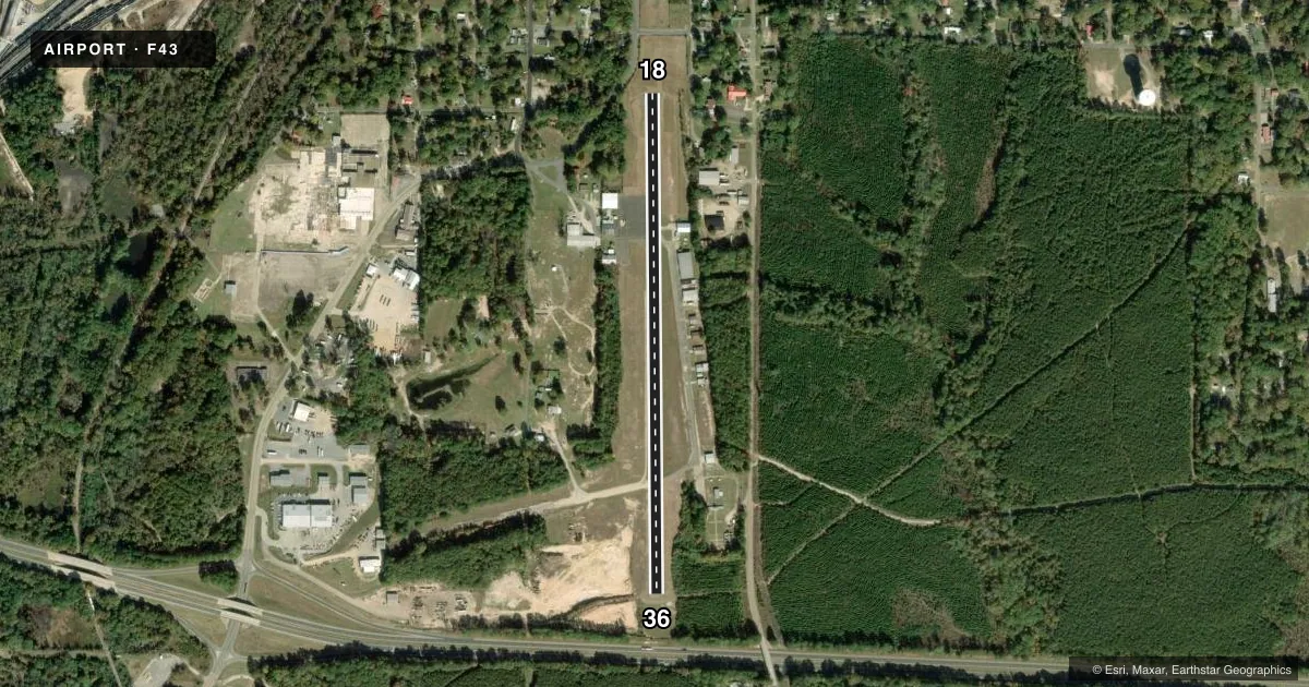
Runways & pattern
Full pagePattern entry · RWY 18
LEFT TRAFFICRunway end performance
| End | TORA | TODA | ASDA | LDA | VGSI | Approach lights | Obstruction |
|---|---|---|---|---|---|---|---|
| 18 | — | — | — | — | — | — | 60', trees, 930' from thr, 160' R of cntrln, slope 12 |
| 36 | — | — | — | — | PAPI 2-box left(3.5°) | — | 59', trees, 300' from thr, 195' R of cntrln, slope 1 |
Declared distances in feet. TORA = takeoff run available, TODA = takeoff distance, ASDA = accelerate-stop, LDA = landing distance.
Airport sketch
Runways drawn to scale from FAA survey coordinates, rendered over satellite imagery. Not for navigation.
Approaches & charts
Services on the field
Fuel grades, oxygen, maintenance, ramp storage and lighting — as declared to the FAA by the airport operator.
Fuel & services
- Fuel
- 100LL
- Airframe repair
- Major
- Power plant repair
- Major
- Other services
- SURV
Ramp & ground
- Transient storage
- Tie-down
- Landing fee
- No fee published
- Customs
- Not available
- Lighting schedule
- SS-SR
- Beacon schedule
- SS-SR
- Beacon
- White / Green (civil land)(WG)
- Wind indicator
- Yes
- Segmented circle
- No
Fuel & FBOs
Cheapest 100LL and Jet A on the field and nearby. Always confirm with the FBO before taxi.
Airport notes
Surface conditions, obstructions, local procedures, lighting outages and other notes published with each FAA cycle.
General notes
- ULTRALIGHT ACTIVITY ON & INVOF ARPT.
- RWY 18 GROUND DROPS OFF 10+ FT APPROX 40 FT FM RWY END
- RWY 36 GROUND DROPS OFF 10+ FT APPROX 30 FT FM RWY END
- FOR CD CTC FORT WORTH ARTCC AT 817-858-7584.
Fuel notes
- 100LLFOR SVC AFT HRS CALL 870-310-0310; 24 HR SELF SERVICE CREDIT CARD AVBL.
VFR map & nearby airports
VFR sectional. Tap any ICAO chip to open that airport.
Key facts · F43
Answer card- ICAO
- F43
- Name
- EL DORADO DOWNTOWN-STEVENS FLD
- Location
- EL DORADO, ARKANSAS
- Elevation
- 256 ft MSL
- Traffic pattern altitude
- 1,256 ft MSL (1,000 AGL)
- Control tower
- Non-towered (use CTAF)
- Total runways
- 1
- Longest runway
- 18/36 · 3,000 ft
- Published ILS approaches
- 0
- Published frequencies
- 2
- Magnetic variation
- 7°
- Current flight rules
- VFR
- Current wind
- 220° at 4 kt
- Favored runway now
- RWY 18
El Dorado Downtown-Stevens Fld (F43) sits in El Dorado, Arkansas. Field elevation is 256 ft MSL. The airport has one runway. Runway 18/36 is 3,000 ft long with an asphalt surface. The field is not towered. CTAF and UNICOM are both 122.8. No ILS approaches are published here.
Pattern altitude is not published. Use the standard 1,000 ft AGL pattern unless local procedures or the current FAA Chart Supplement say otherwise. That puts the light piston pattern around 1,256 ft MSL based on the field elevation, but verify before you fly.
El Dorado Downtown Airport is the on-field FBO. It carries 100LL. 24-hour self-serve credit card fuel is available. After-hours fuel service is also listed in the published remarks. Ultralight activity occurs on and near the airport, so keep a sharp scan in the pattern. The published remarks also note ground drop-offs near both runway ends. Runway 18 drops off more than 10 ft about 40 ft from the end. Runway 36 drops off more than 10 ft about 30 ft from the end. For clearance delivery, contact Fort Worth ARTCC. If you need current operating details, check the current FAA Chart Supplement or call the airport operator directly.