METAR & TAF KDTN
Current METAR
Observed 11:53Z
KDTN 271153Z 22006KT 10SM FEW002 26/23 A2997 RMK AO2 SLP147 T02610233 10289 20256 51013
- Wind
- 220° @ 6 kt
- Visibility
- 10 SM
- Temp / Dew
- 26°C / 23°C
- Altimeter
- 29.97 inHg
- Clouds
- FEW
- Density alt
- 1,481 ft
- Ceiling
- Unlimited
- Rules
- VFR
Airport info & contacts
Manager on record, flight service, ARTCC, attendance schedule and pattern altitude — published by the FAA and refreshed every 28 days.
Location
- From city
- 3 NM N
- VFR sectional
- MEMPHIS
- ARTCC
- ZFW · FORT WORTH
- NOTAM facility
- DTN (NOTAM-D)
Airport manager
- Name
- BRUCE HOLLANDER
- Phone
- 318-349-8330
- Address
- 1550 AIRPORT ROAD, SUITE 100, SHREVEPORT LA 71107
Flight service · Hours
- FSS DRI
- DE RIDDER1-800-WX-BRIEF
- Attendance
- 0700-2200
Frequencies
Tap any row to copy the frequency to your clipboard.
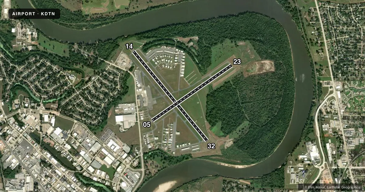
Runways & pattern
Full pagePattern entry · RWY 23
LEFT TRAFFIC| Runway | Heading (°M) | Length | Surface | Traffic |
|---|---|---|---|---|
| 14/32 | 139° / 319° | 5,017 ft | ASPH | Standard L |
| 05/23Favored | 54° / 234° | 4,198 ft | ASPH | Standard L |
Runway end performance
| End | TORA | TODA | ASDA | LDA | VGSI | Approach lights | Obstruction |
|---|---|---|---|---|---|---|---|
| 14 | — | — | — | — | PAPI 4-box left(3°) | — | 63', trees, 1844' from thr, 32' R of cntrln, slope 25 |
| 32 | — | — | — | — | PAPI 4-box right(3°) | — | 79', trees, 2226' from thr, 0' R of cntrln, slope 25 |
| 05 | — | — | — | — | PAPI 2-box left(3°) | — | 6', fence, 200' from thr, 0' R of cntrln, slope 0 |
| 23 | — | — | — | — | PAPI 2-box left(3°) | — | 40', trees, 1800' from thr, 0' R of cntrln, slope 40 |
Declared distances in feet. TORA = takeoff run available, TODA = takeoff distance, ASDA = accelerate-stop, LDA = landing distance.
Airport sketch
Runways drawn to scale from FAA survey coordinates, rendered over satellite imagery. Not for navigation.
Approaches & charts
ILS · 1
Services on the field
Fuel grades, oxygen, maintenance, ramp storage and lighting — as declared to the FAA by the airport operator.
Fuel & services
- Fuel
- 100LLA
- Oxygen (bottled)
- High pressure
- Oxygen (bulk)
- Low pressure
- Airframe repair
- Major
- Power plant repair
- Major
- Other services
- CHTR,INSTR,RNTL
Ramp & ground
- Transient storage
- Tie-down
- Hangar
- Landing fee
- No fee published
- Customs
- Not available
- Lighting schedule
- SS-SR
- Beacon schedule
- SS-SR
- Beacon
- White / Green (civil land)(WG)
- Wind indicator
- Lighted
- Segmented circle
- No
Fuel & FBOs
Cheapest 100LL and Jet A on the field and nearby. Always confirm with the FBO before taxi.
Airport notes
Surface conditions, obstructions, local procedures, lighting outages and other notes published with each FAA cycle.
General notes
- ALL VFR TFC REMAIN WITHIN 1 1/2 MILES NE THRU SW FM THE CENTER OF THE ARPT DUE TO SHREVEPORT/BARKSDALE AFB CLASS C AIRSPACE.
- RWY 14 DESIGNATED CALM WIND RWY.
- ACFT/VEHICLES NOT VSBL FROM ATCT ON N 685 FT OF TWY F.
- WILDLIFE - DEER & BIRDS ON & INVOF ARPT.
- CTC ARPT MGR FOR DSNGD RAMP SPACE FOR PUB USE AT ARPT
Fuel notes
- 100LL100LL AVBL 24 HR SELF SERVICE WITH CREDIT CARD.
- AFOR JET A AFT HRS CALL 318-510-4330. AVBL 24 HR SELF SERVICE WITH CREDIT CARD
Approach & departure obstructions
- 05+6 FT FENCE 120 FT FM RY END ACRS APCH; +15 FT ROAD 188 FT FROM RY END.
- 14PAPI UNUSBL BYD 8 DEGS RIGHT OF CNTRLN
- 05+15 FT ROAD 188 FT FM END OF RY; APCH SLOPE 27:1 BASED ON DSPLCD THLD.
VFR map & nearby airports
VFR sectional. Tap any ICAO chip to open that airport.
Key facts · KDTN
Answer card- ICAO
- KDTN
- Name
- SHREVEPORT DOWNTOWN
- Location
- SHREVEPORT, LOUISIANA
- Elevation
- 179.5 ft MSL
- Traffic pattern altitude
- 1,179.5 ft MSL (1,000 AGL)
- Control tower
- Towered · 0700-2200
- Total runways
- 2
- Longest runway
- 14/32 · 5,017 ft
- Published ILS approaches
- 1
- Published frequencies
- 11
- Magnetic variation
- 1°
- Current flight rules
- VFR
- Current wind
- 220° at 6 kt
- Favored runway now
- RWY 23
Shreveport Downtown Airport sits in Shreveport, Louisiana. The field elevation is 179.3 ft MSL. It has two asphalt runways. The longest is runway 14/32 at 5,016 ft. Runway 05/23 is 4,198 ft. The tower is open daily from 0700 to 2200. One ILS approach is published for runway 14.
Pattern altitude is not published in the facts. Use the standard 1,000 ft AGL for light piston traffic unless ATC or the current Chart Supplement says otherwise. The airport sits inside the Shreveport/Barksdale Air Force Base Class C area. Published remarks say all VFR traffic must stay within 1 1/2 miles northeast through southwest of the airport center. That matters here. Runway 14 is the calm wind runway. The PAPI on 14 is unusable beyond 8 degrees right of centerline.
Tubreaux Aviation is on the field. It carries 100LL and Jet A. 100LL is available 24 hours self-serve with a credit card. Jet A is also available 24 hours self-serve with a credit card. After-hours Jet A support is by phone. Watch the north 685 ft of taxiway F. Aircraft and vehicles are not visible from the tower there. Wildlife is also reported on and near the airport. For ramp space, contact the airport manager before arrival.