METAR & TAF 3F3
Current METAR
Observed 00:35Z
K3F3 210035Z AUTO 14004KT 10SM SCT027 30/25 A2995 RMK AO2 LTG DSNT S T02950247
- Wind
- 140° @ 4 kt
- Visibility
- 10 SM
- Temp / Dew
- 30°C / 25°C
- Altimeter
- 29.95 inHg
- Clouds
- SCT
- Density alt
- 2,165 ft
- Ceiling
- Unlimited
- Rules
- VFR
Airport info & contacts
Manager on record, flight service, ARTCC, attendance schedule and pattern altitude — published by the FAA and refreshed every 28 days.
Location
- From city
- 3 NM NW
- VFR sectional
- MEMPHIS
- ARTCC
- ZFW · FORT WORTH
- NOTAM facility
- DRI (NOTAM-D)
Airport manager
- Name
- JACKIE MCKINNEY
- Phone
- (318) 871-7900
- Address
- 211 INDEPENDENCE AVE, MANSFIELD LA 71032
Flight service · Hours
- FSS DRI
- DE RIDDER1-800-WX-BRIEF
- Attendance
- MON-FRI · 0800-1700
- SAT-SUN · IREG
Frequencies
Tap any row to copy the frequency to your clipboard.
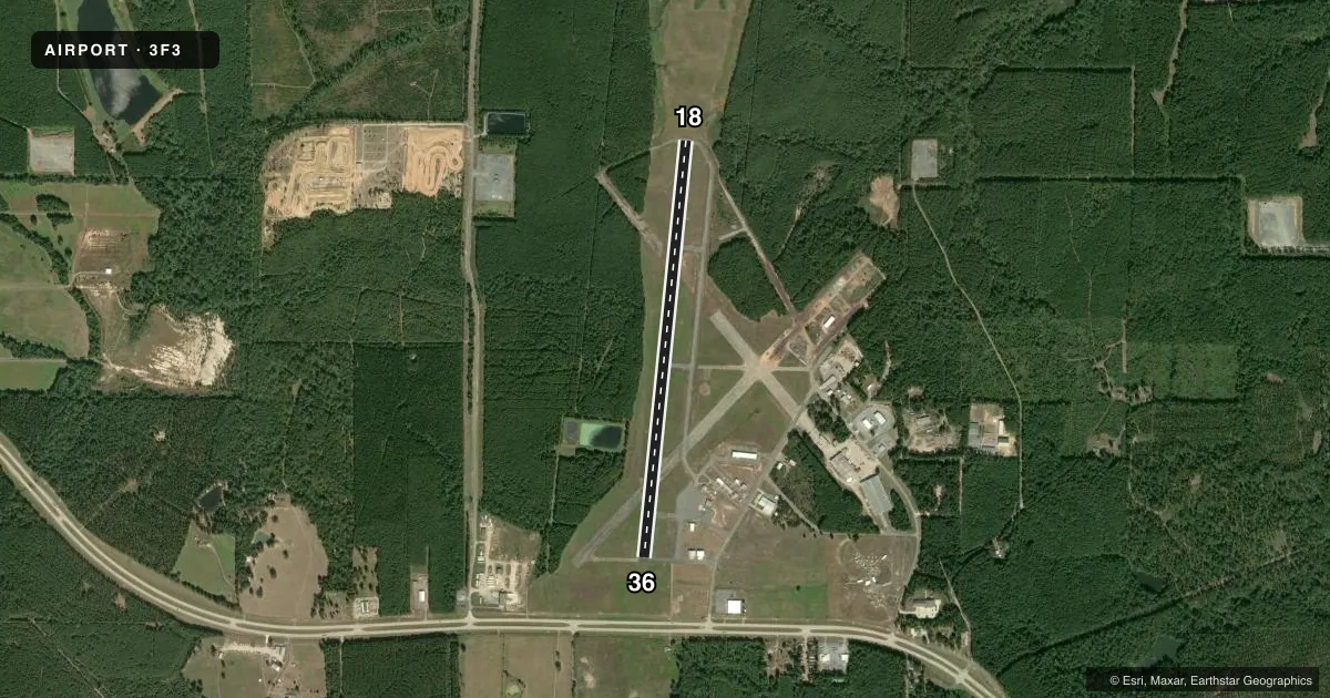
Runways & pattern
Full pagePattern entry · RWY 18
LEFT TRAFFICRunway end performance
| End | TORA | TODA | ASDA | LDA | VGSI | Approach lights | Obstruction |
|---|---|---|---|---|---|---|---|
| 18 | — | — | — | — | PAPI 2-box left(3°) | — | 50', trees, 1609' from thr, 0' R of cntrln, slope 27 |
| 36 | — | — | — | — | PAPI 2-box left(3.5°) | — | 105', trees, 2043' from thr, 0' R of cntrln, slope 17 |
Declared distances in feet. TORA = takeoff run available, TODA = takeoff distance, ASDA = accelerate-stop, LDA = landing distance.
Airport sketch
Runways drawn to scale from FAA survey coordinates, rendered over satellite imagery. Not for navigation.
Approaches & charts
Services on the field
Fuel grades, oxygen, maintenance, ramp storage and lighting — as declared to the FAA by the airport operator.
Fuel & services
- Fuel
- 100LLA
- Oxygen (bottled)
- Not available
- Oxygen (bulk)
- Not available
- Airframe repair
- Not available
- Power plant repair
- Not available
- Other services
- AGRI,INSTR
Ramp & ground
- Transient storage
- Tie-down
- Hangar
- Landing fee
- No fee published
- Customs
- Not available
- Lighting schedule
- SEE RMK
- Beacon schedule
- SS-SR
- Beacon
- White / Green (civil land)(WG)
- Wind indicator
- Lighted
- Segmented circle
- Yes
Fuel & FBOs
Cheapest 100LL and Jet A on the field and nearby. Always confirm with the FBO before taxi.
Airport notes
Surface conditions, obstructions, local procedures, lighting outages and other notes published with each FAA cycle.
General notes
- FOR CD CTC FORT WORTH ARTCC AT 817-858-7584.
- CTC ARPT MGR FOR DSGND RAMP SPACE FOR PUB USE AT ARPT
Lighting notes
- MIRL RY 18/36 PRESET LOW INTST; TO INCR INTST & ACTVT REIL RYS 18 & 36 - CTAF.
Fuel notes
- 100LLFUEL AVBL 24 HRS WITH CREDIT CARD.
- ACURRENTLY INOP
VFR map & nearby airports
VFR sectional. Tap any ICAO chip to open that airport.
Key facts · 3F3
Answer card- ICAO
- 3F3
- Name
- C E 'RUSTY' WILLIAMS
- Location
- MANSFIELD, LOUISIANA
- Elevation
- 324.3 ft MSL
- Traffic pattern altitude
- 1,324.3 ft MSL (1,000 AGL)
- Control tower
- Non-towered (use CTAF)
- Total runways
- 1
- Longest runway
- 18/36 · 5,005 ft
- Published ILS approaches
- 0
- Published frequencies
- 4
- Magnetic variation
- 4°
- Current flight rules
- VFR
- Current wind
- 140° at 4 kt
- Favored runway now
- RWY 18
C E 'Rusty' Williams Airport is in Mansfield, Louisiana. Field elevation is 324.3 ft MSL. The airport has one runway. Runway 18/36 is 5,005 ft long with an asphalt surface. There is no control tower. The pattern altitude is not published in the facts, so use the standard 1,000 ft AGL pattern unless the current Chart Supplement says otherwise.
No ILS approaches are published here. That matters if you are planning an IFR arrival. Check the current Chart Supplement for the latest approach and airport data before you launch. The published remarks also say 100LL is available 24 hours with credit card. Fuel type A is currently inoperative. If you need ramp space for public use, contact the airport manager before arrival.
Runway lighting on 18/36 is preset to low intensity. Use the CTAF to increase intensity. Use it to activate the runway end identifier lights for runways 18 and 36. CTAF and UNICOM are both 122.8. For clearance delivery, contact Fort Worth ARTCC at the number listed in the remarks. This is a non-towered field with a single 5,005 ft runway, so plan your arrival, spacing and self-announce calls with that in mind.