METAR & TAF 4F2
Current METAR
Observed 21:35Z
K4F2 262135Z AUTO 26003KT 10SM CLR 36/18 A2997 RMK AO2 T03600185
- Wind
- 260° @ 3 kt
- Visibility
- 10 SM
- Temp / Dew
- 36°C / 18°C
- Altimeter
- 29.97 inHg
- Clouds
- CLR
- Density alt
- 2,766 ft
- Ceiling
- Unlimited
- Rules
- VFR
Airport info & contacts
Manager on record, flight service, ARTCC, attendance schedule and pattern altitude — published by the FAA and refreshed every 28 days.
Location
- From city
- 2 NM E
- VFR sectional
- MEMPHIS
- ARTCC
- ZFW · FORT WORTH
- NOTAM facility
- FTW (NOTAM-D)
Airport manager
- Name
- ROBERT DUNCAN
- Phone
- 903-693-7856
- Address
- 1305 HIGHWAY 79 NORTH, CARTHAGE TX 75633
Flight service · Hours
- FSS FTW
- FORT WORTH1-800-WX-BRIEF
- Attendance
- MON-FRI · 0800-1700
Frequencies
Tap any row to copy the frequency to your clipboard.
Runways & pattern
Full pagePattern entry · RWY 17
LEFT TRAFFICRunway end performance
| End | TORA | TODA | ASDA | LDA | VGSI | Approach lights | Obstruction |
|---|---|---|---|---|---|---|---|
| 17 | — | — | — | — | PAPI 4-box left(3°) | — | 25', trees, 620' from thr, 172' R of cntrln, slope 16 |
| 35 | — | — | — | — | PAPI 4-box left(4°) | — | 80', trees, 1900' from thr, 100' R of cntrln, slope 21 |
Declared distances in feet. TORA = takeoff run available, TODA = takeoff distance, ASDA = accelerate-stop, LDA = landing distance.
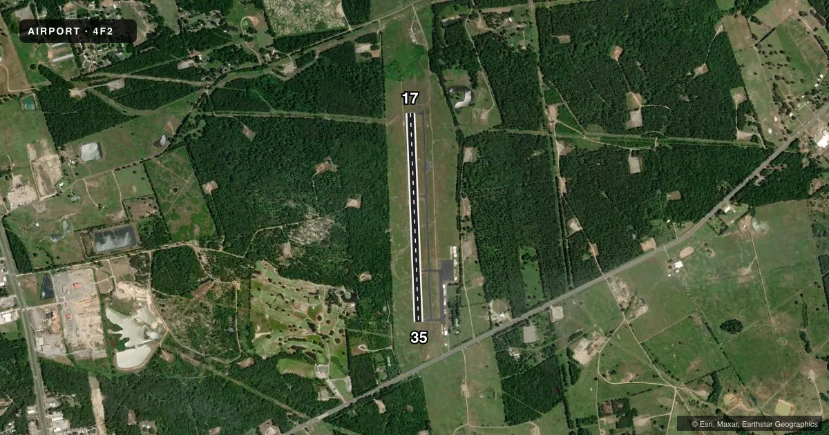
Airport sketch
Runways drawn to scale from FAA survey coordinates, rendered over satellite imagery. Not for navigation.
Approaches & charts
Services on the field
Fuel grades, oxygen, maintenance, ramp storage and lighting — as declared to the FAA by the airport operator.
Fuel & services
- Fuel
- 100LL
- Oxygen (bottled)
- Not available
- Oxygen (bulk)
- Not available
Ramp & ground
- Transient storage
- Tie-down
- Landing fee
- No fee published
- Customs
- Not available
- Lighting schedule
- SEE RMK
- Beacon schedule
- SS-SR
- Beacon
- White / Green (civil land)(WG)
- Wind indicator
- Lighted
- Segmented circle
- Yes
Fuel & FBOs
Cheapest 100LL and Jet A on the field and nearby. Always confirm with the FBO before taxi.
Airport notes
Surface conditions, obstructions, local procedures, lighting outages and other notes published with each FAA cycle.
General notes
- DEER ON & INVOF RWY.
- FOR CD CTC FORT WORTH ARTCC AT 817-858-7584.
- GATE ACCESS CTAF#. TERMINAL ACCESS CTAF
Lighting notes
- MIRL RWY 17/35 PRESET LOW INTST; TO INCR INTST ACTVT - CTAF. PAPI OPR CONSLY.
Fuel notes
- 100LLFUEL 24 HRS SELF-SERVE.
Approach & departure obstructions
- 17MKGS FADED.
- 35MKGS FADED.
Other notes
- THIS AIRPORT HAS BEEN SURVEYED BY THE NATIONAL GEODETIC SURVEY.
- MANAGERMGR CELL 903-690-2833, SHERIFF OFC 903-693-0333.
- 17/35EXTENSIVE CRACKING, LOOSE STONES ON PAVEMENT.
VFR map & nearby airports
VFR sectional. Tap any ICAO chip to open that airport.
Key facts · 4F2
Answer card- ICAO
- 4F2
- Name
- PANOLA COUNTY-SHARPE FLD
- Location
- CARTHAGE, TEXAS
- Elevation
- 248 ft MSL
- Traffic pattern altitude
- 1,248 ft MSL (1,000 AGL)
- Control tower
- Non-towered (use CTAF)
- Total runways
- 1
- Longest runway
- 17/35 · 4,000 ft
- Published ILS approaches
- 0
- Published frequencies
- 4
- Magnetic variation
- 4°
- Current flight rules
- VFR
- Current wind
- 260° at 3 kt
- Favored runway now
- RWY 17
Panola County-Sharpe Fld sits in Carthage, Texas. Field elevation is 248 ft MSL. The airport has one runway. Runway 17/35 is 4,000 ft long with an asphalt surface. There is no control tower. The pattern altitude is not published, so use the standard 1,000 ft AGL for light piston traffic unless the current Chart Supplement says otherwise. No ILS approaches are published here.
The on-field FBO is Panola County Airport. It carries AVGAS 100LL. Fuel is available 24 hours by self-service. The runway lights on 17/35 are preset to low intensity. Use the CTAF to increase lighting if needed. The precision approach path indicator operates continuously. Deer are on and near the runway, so plan your arrival and departure with that in mind. Runway markings on both ends are faded. The pavement also has extensive cracking and loose stones on 17/35. Watch your rollout and taxi closely.
This is an uncontrolled field with CTAF and UNICOM on 122.8. Approach and departure service is through Shreveport on 119.9 or 335.55. For clearance delivery, contact Fort Worth ARTCC. If you are new to the airport, verify current runway condition, lighting use and any local procedures with the airport operator or the FBO before you go.