METAR & TAF KRFI
Current METAR
Observed 13:35Z
KRFI 271335Z AUTO 23006KT 9SM CLR 28/22 A3000 RMK AO2 T02750225 $
- Wind
- 230° @ 6 kt
- Visibility
- 9 SM
- Temp / Dew
- 28°C / 22°C
- Altimeter
- 30.00 inHg
- Clouds
- CLR
- Density alt
- 2,009 ft
- Ceiling
- Unlimited
- Rules
- VFR
Airport info & contacts
Manager on record, flight service, ARTCC, attendance schedule and pattern altitude — published by the FAA and refreshed every 28 days.
Location
- From city
- 3 NM W
- VFR sectional
- MEMPHIS
- ARTCC
- ZFW · FORT WORTH
- NOTAM facility
- FTW (NOTAM-D)
Airport manager
- Name
- ALEXA MCANALLY
- Phone
- 903-657-7081
- Address
- 3500 COUNTY ROAD 416A, HENDERSON TX 75654
Flight service · Hours
- FSS FTW
- FORT WORTH1-800-WX-BRIEF
- Attendance
- 0800-1700
Frequencies
Tap any row to copy the frequency to your clipboard.
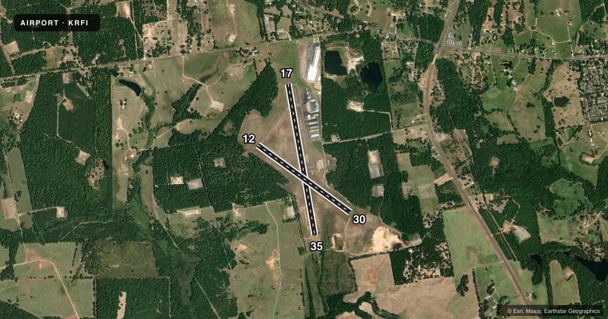
Runways & pattern
Full pagePattern entry · RWY 17
LEFT TRAFFIC| Runway | Heading (°M) | Length | Surface | Traffic |
|---|---|---|---|---|
| 17/35Favored | 167° / 347° | 4,005 ft | ASPH | Standard L |
| 12/30 | 123° / 303° | 3,002 ft | ASPH | Standard L |
Runway end performance
| End | TORA | TODA | ASDA | LDA | VGSI | Approach lights | Obstruction |
|---|---|---|---|---|---|---|---|
| 17 | — | — | — | — | PAPI 2-box left(3°) | — | 86', trees, 1770' from thr, 520' R of cntrln, slope 18 |
| 35 | — | — | — | — | PAPI 2-box left(3°) | — | 25', trees, 450' from thr, 100' R of cntrln, slope 10 |
| 12 | — | — | — | — | — | — | 40', trees, 540' from thr, 160' R of cntrln, slope 8 |
| 30 | — | — | — | — | — | — | 100', trees, 2000' from thr, 0' R of cntrln, slope 18 |
Declared distances in feet. TORA = takeoff run available, TODA = takeoff distance, ASDA = accelerate-stop, LDA = landing distance.
Airport sketch
Runways drawn to scale from FAA survey coordinates, rendered over satellite imagery. Not for navigation.
Approaches & charts
Services on the field
Fuel grades, oxygen, maintenance, ramp storage and lighting — as declared to the FAA by the airport operator.
Fuel & services
- Fuel
- 100LL
- Oxygen (bottled)
- Not available
- Oxygen (bulk)
- Not available
Ramp & ground
- Transient storage
- Tie-down
- Landing fee
- No fee published
- Customs
- Not available
- Lighting schedule
- SS-SR
- Beacon schedule
- SS-SR
- Beacon
- White / Green (civil land)(WG)
- Wind indicator
- Lighted
- Segmented circle
- Yes
Fuel & FBOs
Cheapest 100LL and Jet A on the field and nearby. Always confirm with the FBO before taxi.
Airport notes
Surface conditions, obstructions, local procedures, lighting outages and other notes published with each FAA cycle.
General notes
- FOR CD CTC FORT WORTH ARTCC AT 817-858-7584.
Fuel notes
- 100LLFUEL 24 HRS SELF SERVE.
Approach & departure obstructions
- 12MRKGS FADED.
- 30MRKGS FADED.
Other notes
- 12/30EXTSV CRACKING.
VFR map & nearby airports
VFR sectional. Tap any ICAO chip to open that airport.
Key facts · KRFI
Answer card- ICAO
- KRFI
- Name
- RUSK COUNTY
- Location
- HENDERSON, TEXAS
- Elevation
- 441.9 ft MSL
- Traffic pattern altitude
- 1,441.9 ft MSL (1,000 AGL)
- Control tower
- Non-towered (use CTAF)
- Total runways
- 2
- Longest runway
- 17/35 · 4,005 ft
- Published ILS approaches
- 0
- Published frequencies
- 4
- Magnetic variation
- 3°
- Current flight rules
- VFR
- Current wind
- 230° at 6 kt
- Favored runway now
- RWY 17
Rusk County Airport sits in Henderson, Texas. Field elevation is 441.9 ft MSL. The airport has two asphalt runways. The longest is runway 17/35 at 4,005 ft. There is no control tower. CTAF and UNICOM are both 122.8. No ILS approaches are published here.
For pattern work, the published pattern altitude is not listed. Use the standard 1,000 ft AGL pattern unless current local guidance says otherwise. That puts the light-piston pattern at about 1,442 ft MSL based on the field elevation. The on-field FBO is Rusk County Airport. It carries 100LL. Self-serve 100LL is available 24 hours.
A few runway notes matter here. Runway 12 and runway 30 both have faded markings. Runway 12/30 also has extensive cracking. That makes a careful taxi and takeoff brief worth doing before you roll. For IFR planning, clearance delivery is handled through Fort Worth ARTCC. If you need current operational details, check the current FAA Chart Supplement or call the airport operator directly. This is a non-towered field with published approach and departure frequencies through Longview. Expect normal self-announce traffic on CTAF and plan your arrival with the runway condition in mind.