METAR & TAF 6X0
6X0 does not publish a METAR.
Showing the nearest reporting station: KJSO (CHEROKEE COUNTY) · 14.3 NM away. Conditions at 6X0 may differ.
METAR · KJSO
Observed 15:15Z
KJSO 271515Z AUTO 25008KT 10SM CLR 30/24 A2998 RMK AO2 T02950236 $
- Wind
- 250° @ 8 kt
- Visibility
- 10 SM
- Temp / Dew
- 30°C / 24°C
- Altimeter
- 29.98 inHg
- Clouds
- CLR
- Density alt
- 2,457 ft
- Ceiling
- Unlimited
- Rules
- VFR
Airport info & contacts
Manager on record, flight service, ARTCC, attendance schedule and pattern altitude — published by the FAA and refreshed every 28 days.
Location
- From city
- 2 NM N
- VFR sectional
- DALLAS-FT WORTH
- ARTCC
- ZFW · FORT WORTH
- NOTAM facility
- FTW (NOTAM-D)
Airport manager
- Name
- JIM TARRANT, JR.
- Phone
- 903-574-1760
- Address
- P O BOX 457, BULLARD TX 75757-0457
Flight service · Hours
- FSS FTW
- FORT WORTH1-800-WX-BRIEF
- Attendance
- Unattended
Frequencies
Tap any row to copy the frequency to your clipboard.
Runways & pattern
Full pagePattern entry · RWY 30
LEFT TRAFFICRunway end performance
| End | TORA | TODA | ASDA | LDA | VGSI | Approach lights | Obstruction |
|---|---|---|---|---|---|---|---|
| 12 | — | — | — | — | — | — | 30', trees, 0' from thr, 50' R of cntrln, slope 0 |
| 30 | — | — | — | — | — | — | 40', trees, 0' from thr, 60' R of cntrln, slope 0 |
Declared distances in feet. TORA = takeoff run available, TODA = takeoff distance, ASDA = accelerate-stop, LDA = landing distance.
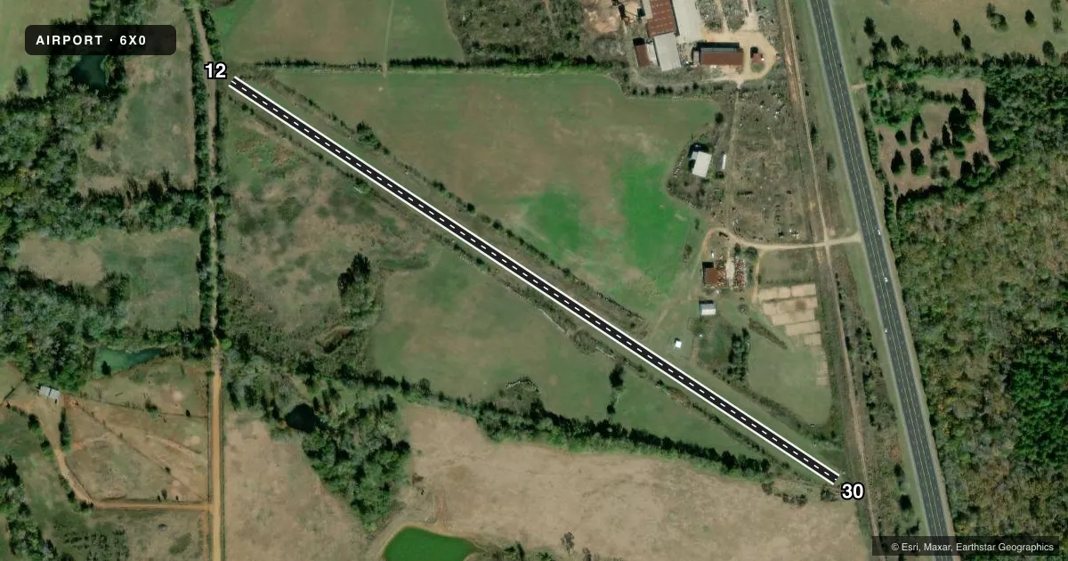
Airport sketch
Runways drawn to scale from FAA survey coordinates, rendered over satellite imagery. Not for navigation.
Approaches & charts
Services on the field
Fuel grades, oxygen, maintenance, ramp storage and lighting — as declared to the FAA by the airport operator.
Fuel & services
- Fuel
- Not available
- Airframe repair
- Not available
- Power plant repair
- Not available
Ramp & ground
- Transient storage
- Not published
- Landing fee
- No fee published
- Wind indicator
- Yes
- Segmented circle
- No
Fuel & FBOs
Cheapest 100LL and Jet A on the field and nearby. Always confirm with the FBO before taxi.
Airport notes
Surface conditions, obstructions, local procedures, lighting outages and other notes published with each FAA cycle.
General notes
- 2059 FT MSL LGTD ANTENNA 2.75 MILES SW OF ARPT.
- RWY 30 25 FT MKD PLINE ACRS APCH AT THR.
- RC MODEL ACFT OPS ON RWY NEAR WINDSOCK & TWY.
- FOR CD CTC FORT WORTH ARTCC AT 817-858-7584.
Approach & departure obstructions
- 1230-40 FT TREES ALG BOTH EDGES, FULL LEN.
Other notes
- VFR ONLY; PROVIDED EACH RWY END IS MAINTAINED FOR A 20:1 APCH.
- 12/30FERAL HOGS ON ARPT, RWY SFC MAY BE DAMAGED. RWY COND NOT REG MON.
VFR map & nearby airports
VFR sectional. Tap any ICAO chip to open that airport.
Key facts · 6X0
Answer card- ICAO
- 6X0
- Name
- TARRANT FLD
- Location
- MOUNT SELMAN, TEXAS
- Elevation
- 590 ft MSL
- Traffic pattern altitude
- 1,590 ft MSL (1,000 AGL)
- Control tower
- Non-towered (use CTAF)
- Total runways
- 1
- Longest runway
- 12/30 · 2,700 ft
- Published ILS approaches
- 0
- Published frequencies
- 1
- Magnetic variation
- 6°
- Current flight rules
- VFR
- Current wind
- 250° at 8 kt
- Favored runway now
- RWY 30
Tarrant Fld is in Mount Selman, Texas. The field elevation is 590 ft MSL. It has one runway, 12/30 and the longest runway is 2,700 ft of turf. This is a non-towered field. CTAF is 122.9. No ILS approaches are published.
The pattern altitude is not published in the facts. Use the standard 1,000 ft AGL pattern unless the current FAA Chart Supplement says otherwise. That puts the light piston pattern at about 1,590 ft MSL based on the field elevation. Runway 12 has 30 to 40 ft trees along both edges for the full length. Runway 30 has a marked 25 ft power line across the approach at the threshold. Feral hogs are reported on the airport. The runway surface may be damaged. Condition is not regularly monitored. Radio control model aircraft operations also occur near the windsock and taxiway. Visual flight rules only are permitted if each runway end keeps a 20 to 1 approach surface. There are no on-field FBOs listed. Call the airport operator or the field directly before arrival for current services.