METAR & TAF 07F
07F does not publish a METAR.
Showing the nearest reporting station: KJXI (FOX STEPHENS FLD/GILMER MUNI) · 10.2 NM away. Conditions at 07F may differ.
METAR · KJXI
Observed 02:35Z
KJXI 270235Z AUTO 00000KT 10SM CLR 29/16 A2996 RMK AO2 T02940162
- Wind
- 000° @ 0 kt
- Visibility
- 10 SM
- Temp / Dew
- 29°C / 16°C
- Altimeter
- 29.96 inHg
- Clouds
- CLR
- Density alt
- 1,998 ft
- Ceiling
- Unlimited
- Rules
- VFR
Airport info & contacts
Manager on record, flight service, ARTCC, attendance schedule and pattern altitude — published by the FAA and refreshed every 28 days.
Location
- From city
- 2 NM SW
- VFR sectional
- MEMPHIS
- ARTCC
- ZFW · FORT WORTH
- NOTAM facility
- FTW (NOTAM-D)
Airport manager
- Name
- CHARLIE SMITH
- Phone
- 903-845-2586
- Address
- 519 E BROADWAY AVE, PO BOX 1725, GLADEWATER TX 75647
Flight service · Hours
- FSS FTW
- FORT WORTH1-800-WX-BRIEF
- Attendance
- 0800-1700
Frequencies
Tap any row to copy the frequency to your clipboard.
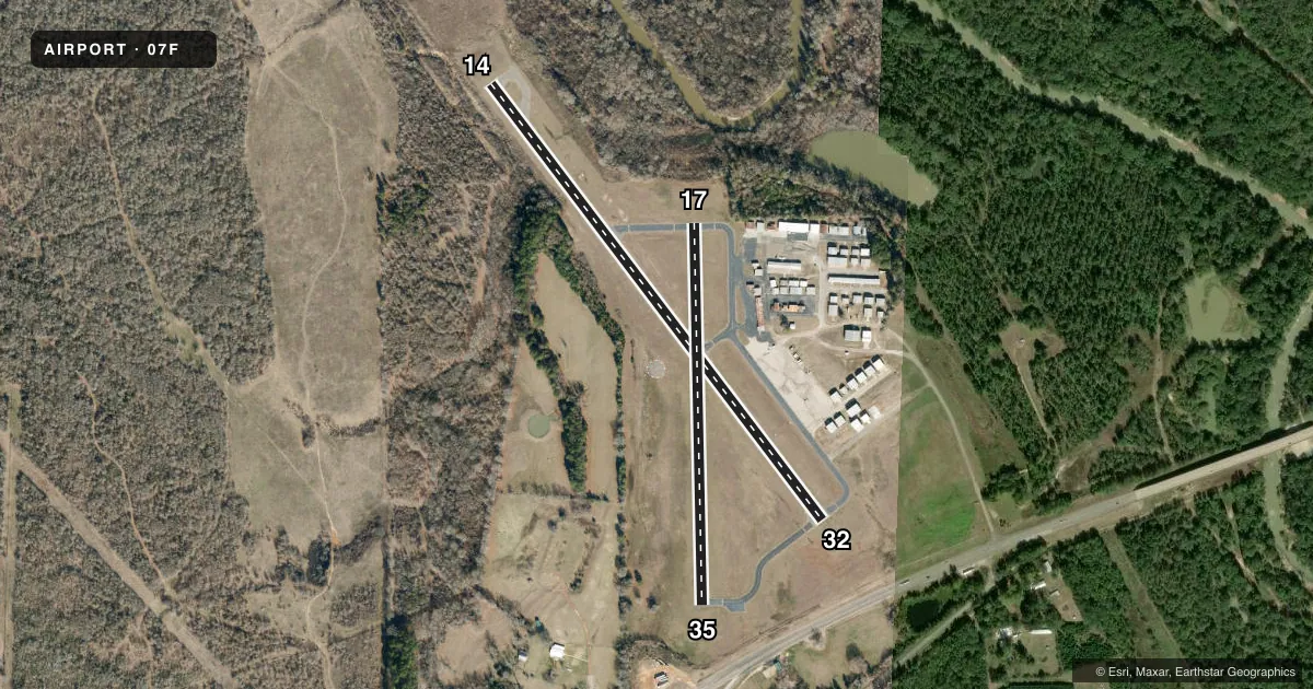
Runways & pattern
Full pagePattern entry · RWY 14
LEFT TRAFFIC| Runway | Heading (°M) | Length | Surface | Traffic |
|---|---|---|---|---|
| 14/32 | 140° / 320° | 3,299 ft | ASPH | Standard L |
| 17/35 | 176° / 356° | 2,300 ft | ASPH | Standard L |
Runway end performance
| End | TORA | TODA | ASDA | LDA | VGSI | Approach lights | Obstruction |
|---|---|---|---|---|---|---|---|
| 14 | — | — | — | — | PAPI 2-box left(3°) | — | 25', trees, 201' from thr, 130' R of cntrln, slope 0 |
| 32 | — | — | — | — | — | — | 85', trees, 1050' from thr, 415' R of cntrln, slope 10 |
| 17 | — | — | — | — | — | — | 45', trees, 268' from thr, 125' R of cntrln, slope 1 |
| 35 | — | — | — | — | — | — | 40', trees, 375' from thr, 55' R of cntrln, slope 4 |
Declared distances in feet. TORA = takeoff run available, TODA = takeoff distance, ASDA = accelerate-stop, LDA = landing distance.
Airport sketch
Runways drawn to scale from FAA survey coordinates, rendered over satellite imagery. Not for navigation.
Approaches & charts
Services on the field
Fuel grades, oxygen, maintenance, ramp storage and lighting — as declared to the FAA by the airport operator.
Fuel & services
- Fuel
- 100LL
- Oxygen (bottled)
- Not available
- Oxygen (bulk)
- Not available
- Airframe repair
- Not available
- Power plant repair
- Not available
- Other services
- INSTR,PAJA,RNTL
Ramp & ground
- Transient storage
- Tie-down
- Landing fee
- No fee published
- Customs
- Not available
- Lighting schedule
- SS-SR
- Beacon schedule
- SS-SR
- Beacon
- White / Green (civil land)(WG)
- Wind indicator
- Lighted
- Segmented circle
- No
Fuel & FBOs
Cheapest 100LL and Jet A on the field and nearby. Always confirm with the FBO before taxi.
Airport notes
Surface conditions, obstructions, local procedures, lighting outages and other notes published with each FAA cycle.
General notes
- FOR CD CTC FORT WORTH ARTCC AT 817-858-7584.
- ARPT PHYS ADDR 1300 US-271, GLADEWATER, TX
Approach & departure obstructions
- 1415 FT TREES, 0-199 FT DSTC, 84 FT R.
- 3212 FT TREES, 50 FT DSTC, 130 FT L.
- 14CONTROLLING OBSTRUCTION EXCEEDS A 45 DEGREE SLOPE
Other notes
- 1FOR SVC AFT HRS CALL 903-235-0784.
- 17/35NMRS CRACKS, LOOSE STONES.
VFR map & nearby airports
VFR sectional. Tap any ICAO chip to open that airport.
Key facts · 07F
Answer card- ICAO
- 07F
- Name
- GLADEWATER MUNI
- Location
- GLADEWATER, TEXAS
- Elevation
- 296.5 ft MSL
- Traffic pattern altitude
- 1,296.5 ft MSL (1,000 AGL)
- Control tower
- Non-towered (use CTAF)
- Total runways
- 2
- Longest runway
- 14/32 · 3,299 ft
- Published ILS approaches
- 0
- Published frequencies
- 3
- Magnetic variation
- 3°
- Current flight rules
- VFR
- Current wind
- 000° at 0 kt
- Favored runway now
- –
Gladewater Muni sits in Gladewater, Texas. Field elevation is 296.5 ft MSL. The airport has two asphalt runways. The longest is runway 14/32 at 3,299 ft. There is no control tower. No ILS approaches are published here.
Pattern altitude is not published. Use 1,000 ft AGL as the standard light piston pattern reference unless the current Chart Supplement says otherwise. That puts the pattern at about 1,296.5 ft MSL based on the field elevation. Runway 17/35 is 2,300 ft long. The published remarks matter here. Runway 17/35 has numerous cracks and loose stones. Runway 14 has a controlling obstruction that exceeds a 45 degree slope. There are also 15-foot trees near runway 14. Runway 32 has 12-foot trees off the left side.
No on-field FBOs are listed. Contact the airport operator directly before arrival, or call the field on CTAF for current FBO availability. CTAF is 122.9. Approach and departure service is on the Longview frequencies. For clearance delivery, contact Fort Worth ARTCC. First-time pilots should plan for an uncontrolled field with published obstruction notes and no ILS backup. Check the current Chart Supplement for any noise or curfew restrictions before flying into the field.