METAR & TAF 3F9
3F9 does not publish a METAR.
Showing the nearest reporting station: KJDD (WOOD COUNTY/COLLINS FLD) · 4.0 NM away. Conditions at 3F9 may differ.
METAR · KJDD
Observed 10:35Z
KJDD 271035Z AUTO 21004KT 10SM CLR 26/22 A2994 RMK AO2 T02560221 $
- Wind
- 210° @ 4 kt
- Visibility
- 10 SM
- Temp / Dew
- 26°C / 22°C
- Altimeter
- 29.94 inHg
- Clouds
- CLR
- Density alt
- 1,828 ft
- Ceiling
- Unlimited
- Rules
- VFR
Airport info & contacts
Manager on record, flight service, ARTCC, attendance schedule and pattern altitude — published by the FAA and refreshed every 28 days.
Location
- From city
- 1 NM W
- VFR sectional
- DALLAS-FT WORTH
- ARTCC
- ZFW · FORT WORTH
- NOTAM facility
- FTW (NOTAM-D)
Airport manager
- Name
- LUPITA A. WISENER
- Phone
- 903-569-1929
- Address
- 1412 COUNTRY CLUB DRIVE, MINEOLA TX 75773-1419
Flight service · Hours
- FSS FTW
- FORT WORTH1-800-WX-BRIEF
- Attendance
- ALL
Frequencies
Tap any row to copy the frequency to your clipboard.
Runways & pattern
Full pagePattern entry · RWY 18L
LEFT TRAFFIC| Runway | Heading (°M) | Length | Surface | Traffic |
|---|---|---|---|---|
| 18R/36LFavored | 178° / 358° | 3,234 ft | TURF | Standard L |
| 18L/36R | 179° / 359° | 3,203 ft | ASPH | Standard L |
Runway end performance
| End | TORA | TODA | ASDA | LDA | VGSI | Approach lights | Obstruction |
|---|---|---|---|---|---|---|---|
| 18R | — | — | — | — | — | — | 80', trees, 0' from thr, 90' R of cntrln, slope 0 |
| 36L | — | — | — | — | — | — | 50', trees, 0' from thr, 124' R of cntrln, slope 0 |
| 18L | — | — | — | — | — | — | 80', trees, 201' from thr, 65' R of cntrln, slope 0 |
| 36R | — | — | — | — | — | — | 80', trees, 201' from thr, 125' R of cntrln, slope 0 |
Declared distances in feet. TORA = takeoff run available, TODA = takeoff distance, ASDA = accelerate-stop, LDA = landing distance.
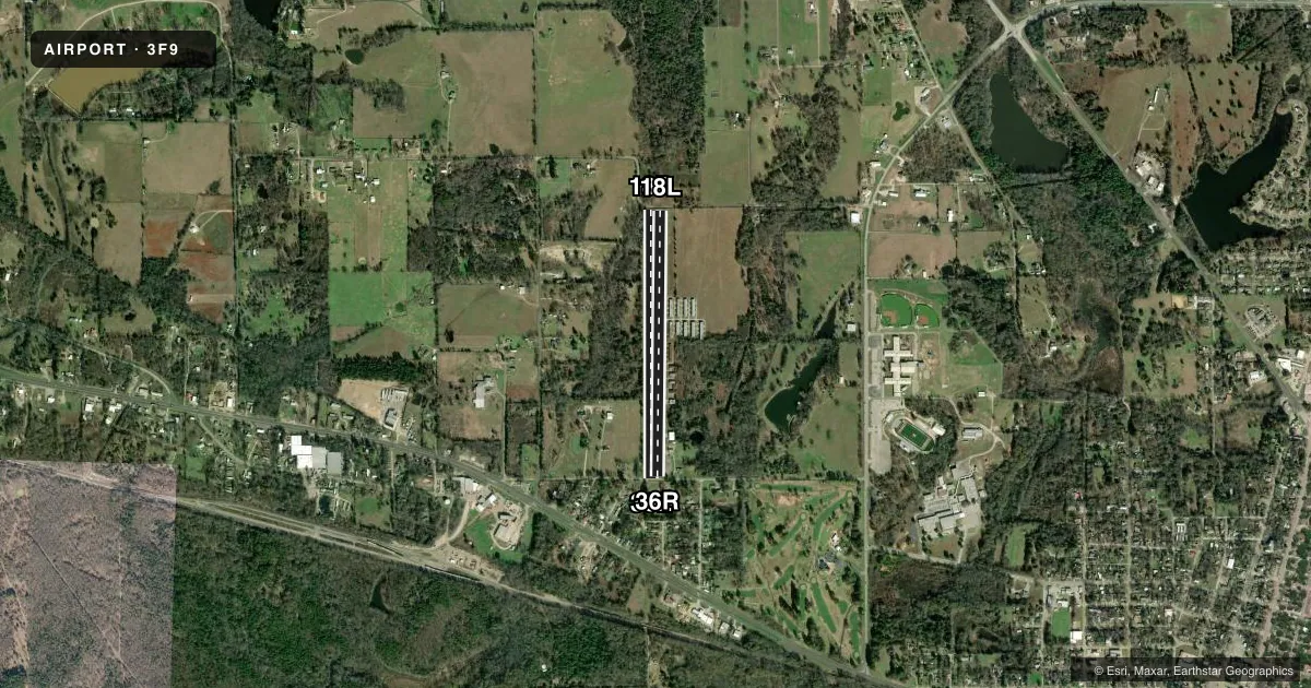
Airport sketch
Runways drawn to scale from FAA survey coordinates, rendered over satellite imagery. Not for navigation.
Approaches & charts
Services on the field
Fuel grades, oxygen, maintenance, ramp storage and lighting — as declared to the FAA by the airport operator.
Fuel & services
- Fuel
- 100LL
- Oxygen (bottled)
- Not available
- Oxygen (bulk)
- Not available
- Airframe repair
- Major
- Power plant repair
- Major
- Other services
- INSTR,SURV
Ramp & ground
- Transient storage
- Tie-down
- Landing fee
- No fee published
- Customs
- Not available
- Lighting schedule
- SEE RMK
- Beacon schedule
- SS-SR
- Beacon
- White / Green (civil land)(WG)
- Wind indicator
- Yes
- Segmented circle
- No
Fuel & FBOs
Cheapest 100LL and Jet A on the field and nearby. Always confirm with the FBO before taxi.
Airport notes
Surface conditions, obstructions, local procedures, lighting outages and other notes published with each FAA cycle.
General notes
- FOR CD CTC FORT WORTH ARTCC AT 817-858-7584.
Lighting notes
- ACTVT LIRL RWY 18L/36R - CTAF.
Fuel notes
- 100LLFUEL SELF-SVC.
Runway surface & condition
- 18L/36RTHR AT BOTH RWY ENDS MKD BY THREE RED LGTS EACH SIDE.
Approach & departure obstructions
- 18L4 FT FENCE, 15 FT RD AT THR ACRS APCH 5 FT DSTC.
- 36R15 FT RD, 4 FT FENCE AT THR. 80 FT TREES 60 FT DSTC 125 FT L.
- 18LRWY 18L & 36R THRS DSPLCD 140 FT.
- 36RMKD THR DSPLCD 140 FT.
- 18LAPCH RATIO 3:1 AT THR LTS OVR 80 FT TREES, 344 DSTC, 80 FT R.
Other notes
- PRE DATES THE ACT.
- MANAGERAMGR LIVES ADJ.
- 18L/36RRWY SFC LOOSE STONES & ROUGH PATCHES AT THRS. RWY SKED TO BE RESURFACED MID 2025 - MID 2026. EXP ARPT CLOSURE.
VFR map & nearby airports
VFR sectional. Tap any ICAO chip to open that airport.
Key facts · 3F9
Answer card- ICAO
- 3F9
- Name
- MINEOLA WISENER FLD
- Location
- MINEOLA, TEXAS
- Elevation
- 430 ft MSL
- Traffic pattern altitude
- 1,430 ft MSL (1,000 AGL)
- Control tower
- Non-towered (use CTAF)
- Total runways
- 2
- Longest runway
- 18R/36L · 3,234 ft
- Published ILS approaches
- 0
- Published frequencies
- 4
- Magnetic variation
- 2°
- Current flight rules
- VFR
- Current wind
- 210° at 4 kt
- Favored runway now
- RWY 18R
Mineola Wisener Fld sits in Mineola, Texas. Field elevation is 430 ft MSL. The airport has two runways. The longest is 3,234 ft. Runway 18L/36R is asphalt. Runway 18R/36L is turf.
This is an untowered field. CTAF and UNICOM are both 122.8. Approach and departure service is via Longview on 128.75 and 379.15. No ILS approaches are published. Pattern altitude is not published, so use the standard 1,000 ft AGL for light piston traffic unless the current FAA Chart Supplement says otherwise. The on-field FBO is Mineola-Wisener Field. It carries self-serve 100LL. Call (903) 569-1929 before you go if you need current fuel or field status.
The published remarks matter here. Runway 18L/36R has displaced thresholds at both ends. Threshold lights are marked with three red lights on each side. The runway surface has loose stones and rough patches at the thresholds. There are also obstruction notes near both ends, including fences, roads and trees close to the approach path. Resurfacing is scheduled from mid 2025 to mid 2026. Airport closure is expected. A first-time pilot should check the current FAA Chart Supplement and call ahead before planning a landing, especially if using the turf runway or if you need to confirm the field is open.