METAR & TAF F51
F51 does not publish a METAR.
Showing the nearest reporting station: KJDD (WOOD COUNTY/COLLINS FLD) · 16.1 NM away. Conditions at F51 may differ.
METAR · KJDD
Observed 13:35Z
KJDD 271335Z AUTO 23006KT 10SM CLR 28/23 A2997 RMK AO2 T02760227 $
- Wind
- 230° @ 6 kt
- Visibility
- 10 SM
- Temp / Dew
- 28°C / 23°C
- Altimeter
- 29.97 inHg
- Clouds
- CLR
- Density alt
- 2,135 ft
- Ceiling
- Unlimited
- Rules
- VFR
Airport info & contacts
Manager on record, flight service, ARTCC, attendance schedule and pattern altitude — published by the FAA and refreshed every 28 days.
Location
- From city
- 2 NM SE
- VFR sectional
- DALLAS-FT WORTH
- ARTCC
- ZFW · FORT WORTH
- NOTAM facility
- FTW (NOTAM-D)
Airport manager
- Name
- DARYL LAWRENCE
- Phone
- 903-342-3654
- Address
- 501 SOUTH MAIN, WINNSBORO TX 75494
Flight service · Hours
- FSS FTW
- FORT WORTH1-800-WX-BRIEF
- Attendance
- Unattended
Frequencies
Tap any row to copy the frequency to your clipboard.
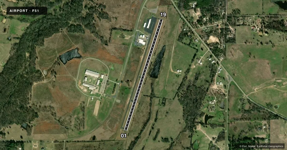
Runways & pattern
Full pagePattern entry · RWY 19
LEFT TRAFFICRunway end performance
| End | TORA | TODA | ASDA | LDA | VGSI | Approach lights | Obstruction |
|---|---|---|---|---|---|---|---|
| 01 | — | — | — | — | — | — | 30', trees, 320' from thr, 125' R of cntrln, slope 4 |
| 19 | — | — | — | — | — | — | 60', trees, 880' from thr, 195' R of cntrln, slope 11 |
Declared distances in feet. TORA = takeoff run available, TODA = takeoff distance, ASDA = accelerate-stop, LDA = landing distance.
Airport sketch
Runways drawn to scale from FAA survey coordinates, rendered over satellite imagery. Not for navigation.
Approaches & charts
Services on the field
Fuel grades, oxygen, maintenance, ramp storage and lighting — as declared to the FAA by the airport operator.
Fuel & services
- Fuel
- 100LLMOGAS
- Oxygen (bottled)
- Not available
- Oxygen (bulk)
- Not available
- Airframe repair
- Minor
- Power plant repair
- Minor
Ramp & ground
- Transient storage
- Tie-down
- Landing fee
- No fee published
- Customs
- Not available
- Lighting schedule
- SEE RMK
- Beacon schedule
- SS-SR
- Beacon
- White / Green (civil land)(WG)
- Wind indicator
- Lighted
- Segmented circle
- Yes
Fuel & FBOs
Cheapest 100LL and Jet A on the field and nearby. Always confirm with the FBO before taxi.
Airport notes
Surface conditions, obstructions, local procedures, lighting outages and other notes published with each FAA cycle.
General notes
- FOR CD CTC FORT WORTH ARTCC AT 817-858-7584.
Lighting notes
- ACTVT MIRL RWY 01/19 - CTAF.
Fuel notes
- 100LLFUEL 24 HR SELF SERVE. MOGAS AVBL.
Approach & departure obstructions
- 0120 FT TREES 90 FT DSTC, 100 FT RIGHT.
- 1920 FT TREES, 87 FT DSTC, 120 FT L.
Other notes
- MANAGEREXT. 500
VFR map & nearby airports
VFR sectional. Tap any ICAO chip to open that airport.
Key facts · F51
Answer card- ICAO
- F51
- Name
- WINNSBORO MUNI
- Location
- WINNSBORO, TEXAS
- Elevation
- 513.4 ft MSL
- Traffic pattern altitude
- 1,513.4 ft MSL (1,000 AGL)
- Control tower
- Non-towered (use CTAF)
- Total runways
- 1
- Longest runway
- 01/19 · 3,215 ft
- Published ILS approaches
- 0
- Published frequencies
- 3
- Magnetic variation
- 8°
- Current flight rules
- VFR
- Current wind
- 230° at 6 kt
- Favored runway now
- RWY 19
Winnsboro Muni sits in Winnsboro, Texas at 513.4 ft MSL. It has one runway, 01/19, which is 3,215 ft asphalt. There is no control tower. The published traffic pattern altitude is not listed, so use the standard 1,000 ft AGL for light piston traffic unless the current Chart Supplement says otherwise.
No ILS approaches are published here. CTAF is 122.9. Approach and departure service is handled by Longview on 128.75 and 379.15. The field has medium intensity runway lights on runway 01/19. They are activated by the CTAF. That matters for night work and after-hours arrivals.
Winnsboro Municipal Airport is on the field and carries AVGAS 100LL plus MOGAS. Fuel is available 24 hours self serve. If you need clearance delivery, Fort Worth ARTCC is listed in the remarks. The runway has tree obstructions near both ends. Trees are noted near runway 19 on the left side. Trees are also noted near runway 01 on the right side. That makes a stabilized approach and good short-field planning important, especially with the 3,215 ft runway length and the lack of published ILS support.