METAR & TAF F53
F53 does not publish a METAR.
Showing the nearest reporting station: KOSA (MOUNT PLEASANT RGNL) · 15.6 NM away. Conditions at F53 may differ.
METAR · KOSA
Observed 11:55Z
KOSA 271155Z AUTO 16003KT 10SM CLR 22/21 A2997 RMK AO2 T02240205 10258 20217
- Wind
- 160° @ 3 kt
- Visibility
- 10 SM
- Temp / Dew
- 22°C / 21°C
- Altimeter
- 29.97 inHg
- Clouds
- CLR
- Density alt
- 1,289 ft
- Ceiling
- Unlimited
- Rules
- VFR
Airport info & contacts
Manager on record, flight service, ARTCC, attendance schedule and pattern altitude — published by the FAA and refreshed every 28 days.
Location
- From city
- 2 NM NW
- VFR sectional
- DALLAS-FT WORTH
- ARTCC
- ZFW · FORT WORTH
- NOTAM facility
- FTW (NOTAM-D)
Airport manager
- Name
- JOHN GANDY
- Phone
- 903-588-2643
- Address
- PO BOX 989, MOUNT VERNON TX 75457
Flight service · Hours
- FSS FTW
- FORT WORTH1-800-WX-BRIEF
- Attendance
- UNATND
Frequencies
Tap any row to copy the frequency to your clipboard.
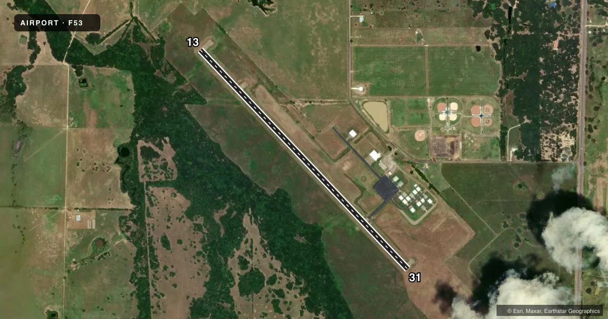
Runways & pattern
Full pagePattern entry · RWY 13
LEFT TRAFFICRunway end performance
| End | TORA | TODA | ASDA | LDA | VGSI | Approach lights | Obstruction |
|---|---|---|---|---|---|---|---|
| 13 | — | — | — | — | PAPI 2-box left(3°) | — | 36', trees, 400' from thr, 250' R of cntrln, slope 5 |
| 31 | — | — | — | — | PAPI 2-box left(3°) | — | 46', trees, 1587' from thr, 100' R of cntrln, slope 30 |
Declared distances in feet. TORA = takeoff run available, TODA = takeoff distance, ASDA = accelerate-stop, LDA = landing distance.
Airport sketch
Runways drawn to scale from FAA survey coordinates, rendered over satellite imagery. Not for navigation.
Approaches & charts
Services on the field
Fuel grades, oxygen, maintenance, ramp storage and lighting — as declared to the FAA by the airport operator.
Fuel & services
- Fuel
- Not available
Ramp & ground
- Transient storage
- Tie-down
- Lighting schedule
- SS-SR
- Beacon schedule
- SS-SR
- Beacon
- White / Green (civil land)(WG)
- Wind indicator
- Lighted
- Segmented circle
- Yes
Fuel & FBOs
Cheapest 100LL and Jet A on the field and nearby. Always confirm with the FBO before taxi.
Airport notes
Surface conditions, obstructions, local procedures, lighting outages and other notes published with each FAA cycle.
General notes
- FOR CD CTC FORT WORTH ARTCC AT 817-858-7584.
Other notes
- PRVDD A 90-DAY NOTICE IS FURNISHED FAA PRIOR TO ACTIVATION OF ARPT.
VFR map & nearby airports
VFR sectional. Tap any ICAO chip to open that airport.
Key facts · F53
Answer card- ICAO
- F53
- Name
- FRANKLIN COUNTY
- Location
- MOUNT VERNON, TEXAS
- Elevation
- 412.1 ft MSL
- Traffic pattern altitude
- 1,412.1 ft MSL (1,000 AGL)
- Control tower
- Non-towered (use CTAF)
- Total runways
- 1
- Longest runway
- 13/31 · 3,900 ft
- Published ILS approaches
- 0
- Published frequencies
- 2
- Magnetic variation
- 6°
- Current flight rules
- VFR
- Current wind
- 160° at 3 kt
- Favored runway now
- RWY 13
Franklin County Airport (F53) is in Mount Vernon, Texas. The field elevation is 412.1 ft MSL. It has one runway, 13/31, which is 3,900 ft long on asphalt. The airport is non-towered. CTAF and UNICOM are both 123.0.
No ILS approaches are published here. The runway headings are 136° and 316° magnetic. Pattern altitude is not published in the facts, so use the current FAA Chart Supplement before you go. For a light piston, standard pattern work is typically planned at 1,000 ft AGL unless published otherwise. Franklin County Airport carries AVGAS 100LL and Jet A through the on-field Franklin County Airport FBO. Call (903) 767-0602 for current service details.
A published remark says to contact Fort Worth ARTCC at 817-858-7584 for clearance delivery. Another remark notes a 90-day notice is furnished to the FAA before airport activation. If you are planning a first visit, verify the current Chart Supplement for any operational notes before departure. This is a straightforward east Texas field with one runway and no tower, so standard self-announce traffic discipline matters.