METAR & TAF KSLR
Current METAR
Observed 12:35Z
KSLR 271235Z AUTO 20009KT 10SM CLR 27/22 A2999 RMK AO2 T02650220 PWINO
- Wind
- 200° @ 9 kt
- Visibility
- 10 SM
- Temp / Dew
- 27°C / 22°C
- Altimeter
- 29.99 inHg
- Clouds
- CLR
- Density alt
- 1,960 ft
- Ceiling
- Unlimited
- Rules
- VFR
Airport info & contacts
Manager on record, flight service, ARTCC, attendance schedule and pattern altitude — published by the FAA and refreshed every 28 days.
Location
- From city
- 2 NM NW
- VFR sectional
- DALLAS-FT WORTH
- ARTCC
- ZFW · FORT WORTH
- NOTAM facility
- SLR (NOTAM-D)
Airport manager
- Name
- JOEY BAKER
- Phone
- 903-885-4911
- Address
- 1220 CESSNA DR., SULPHUR SPRINGS TX 75482
Flight service · Hours
- FSS FTW
- FORT WORTH1-800-WX-BRIEF
- Attendance
- MON-SAT · 0800-1800
- SUN · BY REQUEST
Frequencies
Tap any row to copy the frequency to your clipboard.
Runways & pattern
Full pagePattern entry · RWY 19
LEFT TRAFFICRunway end performance
| End | TORA | TODA | ASDA | LDA | VGSI | Approach lights | Obstruction |
|---|---|---|---|---|---|---|---|
| 01 | — | — | — | — | PAPI 4-box left(3°) | — | 5', fence, 201' from thr, 249' R of cntrln, slope 1 |
| 19 | — | — | — | — | PAPI 4-box left(3°) | — | — |
Declared distances in feet. TORA = takeoff run available, TODA = takeoff distance, ASDA = accelerate-stop, LDA = landing distance.
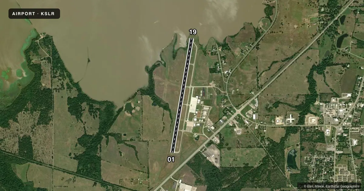
Airport sketch
Runways drawn to scale from FAA survey coordinates, rendered over satellite imagery. Not for navigation.
Approaches & charts
Services on the field
Fuel grades, oxygen, maintenance, ramp storage and lighting — as declared to the FAA by the airport operator.
Fuel & services
- Fuel
- 100LLA
- Airframe repair
- Major
- Power plant repair
- Major
Ramp & ground
- Transient storage
- Tie-down
- Hangar
- Landing fee
- No fee published
- Lighting schedule
- SEE RMK
- Beacon schedule
- SS-SR
- Beacon
- White / Green (civil land)(WG)
- Wind indicator
- Lighted
- Segmented circle
- Yes
Fuel & FBOs
Cheapest 100LL and Jet A on the field and nearby. Always confirm with the FBO before taxi.
Airport notes
Surface conditions, obstructions, local procedures, lighting outages and other notes published with each FAA cycle.
General notes
- BIRDS ON & INVOF ARPT.
- LGT SPORT ACFT OPRG ON WEST SIDE OF RWY.
- RWY 01 45 FT BLDG 1,820 DSTC.
- FOR CD CTC FORT WORTH ARTCC AT 817-858-7584.
- RWY 1, 44 FT UNMKD PLINE, 1530 FT DSTC, 30:1; 58 FT TANK, 1820 FT DSTC, 30 FT L, 27:1; 125 FT ANTENNA, 1515 FT EAST OF RWY 1 END.
Lighting notes
- MIRL RWY 01/19 PRESET LOW DUSK-DAWN. TO INCR INTST AND ACTVT REIL RWYS 01 & 19 - CTAF. PAPI RWYS 01 & 19 OPR CONSLY.
Fuel notes
- 100LL100LL AVBL 24 HRS SELF-SERVE.
Approach & departure obstructions
- 015 FT FENCE 0-199 FT DSTC, 249 FT LEFT.
- 1910 FT BRUSH, 10 FT DSTC, 132 R.
- 19PAPI UNUSBL BYD 8 DEGS RIGHT OF RCL.
Other notes
- THIS AIRPORT HAS BEEN SURVEYED BY THE NATIONAL GEODETIC SURVEY.
- 1FOR ATTENDANT AFT HRS CALL POLICE DISPATCH 903-885-7602.
- 2FOR ATTENDANT ON SUN CALL 903-885-4911 DURG ATTENDED HRS.
VFR map & nearby airports
VFR sectional. Tap any ICAO chip to open that airport.
Key facts · KSLR
Answer card- ICAO
- KSLR
- Name
- SULPHUR SPRINGS MUNI
- Location
- SULPHUR SPRINGS, TEXAS
- Elevation
- 489.3 ft MSL
- Traffic pattern altitude
- 1,489.3 ft MSL (1,000 AGL)
- Control tower
- Non-towered (use CTAF)
- Total runways
- 1
- Longest runway
- 01/19 · 5,001 ft
- Published ILS approaches
- 0
- Published frequencies
- 2
- Magnetic variation
- 3°
- Current flight rules
- VFR
- Current wind
- 200° at 9 kt
- Favored runway now
- RWY 19
Sulphur Springs Muni (KSLR) sits in Sulphur Springs, Texas. The field elevation is 489.3 ft MSL. It has one runway, 01/19, which is 5,001 ft long and paved concrete. There is no control tower. CTAF and UNICOM are both 123.075.
No ILS approaches are published here. Pattern altitude is not published, so use the standard 1,000 ft AGL for light piston traffic unless the current Chart Supplement says otherwise. The on-field FBO is Sulphur Springs Municipal Airport. It carries AVGAS 100LL and Jet A. 100LL is available 24 hours through self-service.
A few remarks matter for the first-time pilot. Runway lights on 01/19 are preset low from dusk to dawn. Use the CTAF to increase intensity and to activate the runway end identifier lights. The PAPI on both ends operates continuously. Watch the published obstructions near both runway ends. There is also bird activity on and near the airport. Light sport aircraft operate on the west side of runway 01/19. For clearance delivery, contact Fort Worth ARTCC. This is a non-towered field, so plan your calls early and keep an eye out for local traffic.