METAR & TAF KGVT
Current METAR
Observed 22:50Z
KGVT 262250Z AUTO 14012KT 10SM CLR 36/19 A2995 RMK AO2
- Wind
- 140° @ 12 kt
- Visibility
- 10 SM
- Temp / Dew
- 36°C / 19°C
- Altimeter
- 29.95 inHg
- Clouds
- CLR
- Density alt
- 3,146 ft
- Ceiling
- Unlimited
- Rules
- VFR
Airport info & contacts
Manager on record, flight service, ARTCC, attendance schedule and pattern altitude — published by the FAA and refreshed every 28 days.
Location
- From city
- 4 NM SE
- VFR sectional
- DALLAS-FT WORTH
- ARTCC
- ZFW · FORT WORTH
- NOTAM facility
- GVT (NOTAM-D)
Airport manager
- Name
- TY HELTON
- Phone
- 903-457-3168
- Address
- GREENVILLE MUNICIPAL AIRPORT, 101 MAJORS RD, GREENVILLE TX 75401
Flight service · Hours
- FSS FTW
- FORT WORTH1-800-WX-BRIEF
- Attendance
- SUN-THU · 0730-1700
- FRI-SAT · 0730-1800
Frequencies
Tap any row to copy the frequency to your clipboard.
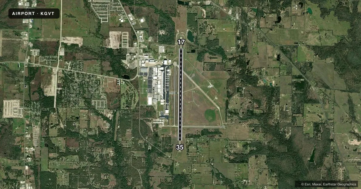
Runways & pattern
Full pagePattern entry · RWY 17
LEFT TRAFFICRunway end performance
| End | TORA | TODA | ASDA | LDA | VGSI | Approach lights | Obstruction |
|---|---|---|---|---|---|---|---|
| 17 | — | — | — | — | PAPI 4-box left(3°) | MALS | 21', ant, 354' from thr, 265' R of cntrln, slope 7 |
| 35 | — | — | — | — | PAPI 4-box left(3°) | — | 7', fence, 201' from thr, 450' R of cntrln, slope 0 |
Declared distances in feet. TORA = takeoff run available, TODA = takeoff distance, ASDA = accelerate-stop, LDA = landing distance.
Airport sketch
Runways drawn to scale from FAA survey coordinates, rendered over satellite imagery. Not for navigation.
Approaches & charts
ILS · 1
Services on the field
Fuel grades, oxygen, maintenance, ramp storage and lighting — as declared to the FAA by the airport operator.
Fuel & services
- Fuel
- 100LLA
- Oxygen (bottled)
- Not available
- Oxygen (bulk)
- Not available
- Airframe repair
- Minor
- Power plant repair
- Minor
- Other services
- AMB,INSTR
Ramp & ground
- Transient storage
- Tie-down
- Landing fee
- No fee published
- Customs
- Not available
- Lighting schedule
- SEE RMK
- Beacon schedule
- SS-SR
- Beacon
- White / Green (civil land)(WG)
- Wind indicator
- Lighted
- Segmented circle
- Yes
Fuel & FBOs
Cheapest 100LL and Jet A on the field and nearby. Always confirm with the FBO before taxi.
Airport notes
Surface conditions, obstructions, local procedures, lighting outages and other notes published with each FAA cycle.
General notes
- MILITARY USE: JASU - 1(B-10) 1(B-10A) 1(MD-3) 1(MA-1) 1(MA-3).
- 89 FT HIGH INTSTY RADIO FREQ ANT 3,700 FT EAST OF RWY 35 AT END OF TXY K.
- TWY E LGTS 47 FT FM PAVEMENT EDGE.
- PPR FOR PAJA ONTO MAJORS FLD.
- WHEN ATCT CLSD, FOR CD CTC FORT WORTH ARTCC AT 817-858-7584.
- WHEN ATCT CLSD AND THERE IS AN EMERG OR INCIDENT ON ARPT, CTC 903-457-5333.
- ACFT NOT VSB FM OPPOSITE END OF RWY.
Lighting notes
- ACTVT MALS RWY 17; REIL RWY 35; MIRL RWY 17/35 - CTAF.
Fuel notes
- 100LL100LL SELF SVC AVBL 24 HRS.
Approach & departure obstructions
- 1710 FT RD. 0-145- DSTC
- 17CTLG OBSTN EXCEEDS A 45 DEG SLP. OBSTN TALLER THAN OBSTN LGT.
Other notes
- NMRS MIL ACFT ON FLD FOR MODIFICATION.
- MANAGERTHELTON@CI.GREENVILLE.TX.US ALT PHONE 214-960-9294
VFR map & nearby airports
VFR sectional. Tap any ICAO chip to open that airport.
Key facts · KGVT
Answer card- ICAO
- KGVT
- Name
- MAJORS
- Location
- GREENVILLE, TEXAS
- Elevation
- 534.9 ft MSL
- Traffic pattern altitude
- 1,534.9 ft MSL (1,000 AGL)
- Control tower
- Towered · 0730-1600 MON-FRI, IRREGULAR OTHER HOURS
- Total runways
- 1
- Longest runway
- 17/35 · 8,030 ft
- Published ILS approaches
- 1
- Published frequencies
- 8
- Magnetic variation
- 5°
- Current flight rules
- VFR
- Current wind
- 140° at 12 kt
- Favored runway now
- RWY 17
Majors sits in Greenville, Texas. Field elevation is 534.9 ft MSL. The airport has one runway, 17/35 and it is 8,030 ft long. The tower is open 0730-1600 Monday through Friday. Other hours are irregular, so check current status before you go. There is one ILS approach. It serves runway 17.
The published pattern altitude is not listed, so use standard 1,000 ft AGL for light piston operations unless ATC or the current Chart Supplement says otherwise. Greenville Aviation is on the field. It carries 100LL and Jet A Prist. 100LL self-serve fuel is available 24 hours. That is useful here because tower coverage is limited outside weekday daytime hours.
A few published remarks matter for planning. Aircraft are not visible from the opposite end of the runway. There is also an obstruction near runway 17 that exceeds a 45 degree slope. A 10-foot road sits close to the runway end. Taxiway E lights sit 47 feet from the pavement edge. The field also has numerous military aircraft on site for modification. If you need clearance delivery when the tower is closed, contact Fort Worth ARTCC. For airport emergencies when the tower is closed, use the published airport phone number. Check the current Chart Supplement for any noise or curfew restrictions before flying into the field.