METAR & TAF KJSO
Current METAR
Observed 16:35Z
KJSO 261635Z AUTO 25007KT 9SM CLR 30/21 A3005 RMK AO2 T03030213 $
- Wind
- 250° @ 7 kt
- Visibility
- 9 SM
- Temp / Dew
- 30°C / 21°C
- Altimeter
- 30.05 inHg
- Clouds
- CLR
- Density alt
- 2,479 ft
- Ceiling
- Unlimited
- Rules
- VFR
Airport info & contacts
Manager on record, flight service, ARTCC, attendance schedule and pattern altitude — published by the FAA and refreshed every 28 days.
Location
- From city
- 6 NM SE
- VFR sectional
- HOUSTON
- ARTCC
- ZFW · FORT WORTH
- NOTAM facility
- JSO (NOTAM-D)
Airport manager
- Name
- RANDA WALKER-BYNUM
- Phone
- 903-586-8219
- Address
- 420 CR 1618, RUSK TX 75785
Flight service · Hours
- FSS FTW
- FORT WORTH1-800-WX-BRIEF
- Attendance
- MON-SAT · 0800-1700
Frequencies
Tap any row to copy the frequency to your clipboard.
Runways & pattern
Full pagePattern entry · RWY 32
LEFT TRAFFICRunway end performance
| End | TORA | TODA | ASDA | LDA | VGSI | Approach lights | Obstruction |
|---|---|---|---|---|---|---|---|
| 14 | — | — | — | — | PAPI 4-box left(3°) | — | 7', trees, 290' from thr, 226' R of cntrln, slope 12 |
| 32 | — | — | — | — | PAPI 4-box left(3°) | — | tree, slope 50 |
Declared distances in feet. TORA = takeoff run available, TODA = takeoff distance, ASDA = accelerate-stop, LDA = landing distance.
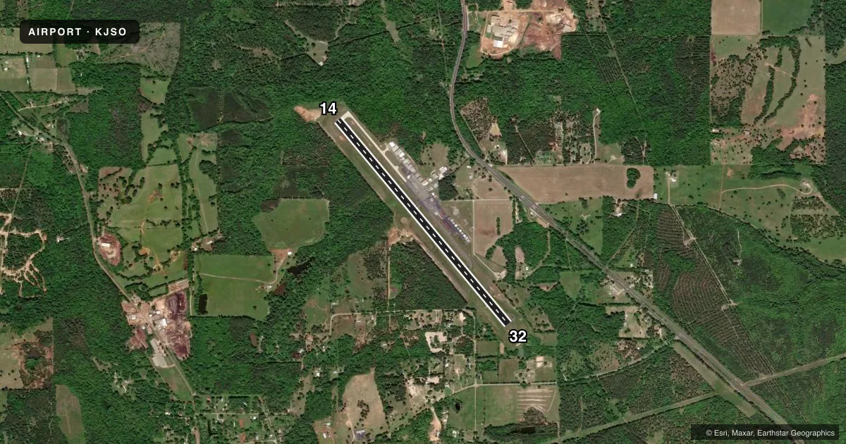
Airport sketch
Runways drawn to scale from FAA survey coordinates, rendered over satellite imagery. Not for navigation.
Approaches & charts
Services on the field
Fuel grades, oxygen, maintenance, ramp storage and lighting — as declared to the FAA by the airport operator.
Fuel & services
- Fuel
- 100LLA
- Oxygen (bottled)
- Not available
- Oxygen (bulk)
- Not available
- Airframe repair
- Major
- Power plant repair
- Major
- Other services
- INSTR,RNTL,SALES
Ramp & ground
- Transient storage
- Tie-down
- Landing fee
- No fee published
- Customs
- Not available
- Lighting schedule
- SEE RMK
- Beacon schedule
- SS-SR
- Beacon
- White / Green (civil land)(WG)
- Wind indicator
- Lighted
- Segmented circle
- Yes
Fuel & FBOs
Cheapest 100LL and Jet A on the field and nearby. Always confirm with the FBO before taxi.
Airport notes
Surface conditions, obstructions, local procedures, lighting outages and other notes published with each FAA cycle.
General notes
- FOR CD CTC FORT WORTH ARTCC AT 817-858-7584.
Lighting notes
- DUSK-DAWN, MIRL RWY 14/32 PRESET LOW INTST; TO INCR INTST AND TO ACTVT REIL RWY 14 - CTAF.
Fuel notes
- 100LL100LL 24 HR SELF-SERVE.
- AJET A FULL SERVE 0800-1700 MON-SAT. SELF-SERVE 24/7.
VFR map & nearby airports
VFR sectional. Tap any ICAO chip to open that airport.
Key facts · KJSO
Answer card- ICAO
- KJSO
- Name
- CHEROKEE COUNTY
- Location
- JACKSONVILLE, TEXAS
- Elevation
- 677.6 ft MSL
- Traffic pattern altitude
- 1,677.6 ft MSL (1,000 AGL)
- Control tower
- Non-towered (use CTAF)
- Total runways
- 1
- Longest runway
- 14/32 · 5,006 ft
- Published ILS approaches
- 0
- Published frequencies
- 4
- Magnetic variation
- 5°
- Current flight rules
- VFR
- Current wind
- 250° at 7 kt
- Favored runway now
- RWY 32
Cherokee County Airport sits in Jacksonville, Texas. Field elevation is 677.6 ft MSL. The airport has one runway. Runway 14/32 is 5,006 ft of asphalt, so it is the length you plan around here.
This is an untowered field. Pattern altitude is not published, so use 1,000 ft AGL for light piston operations unless the current Chart Supplement says otherwise. No ILS approaches are published. The field uses CTAF 122.7, which is also listed as UNICOM. For clearance delivery, Fort Worth ARTCC is the contact listed in the remarks.
Cherokee County Airport is the on-field FBO. It carries 100LL and Jet A Prist. 100LL is available 24 hours a day through self-serve. Jet A is full service from 0800 to 1700 Monday through Saturday. Self-serve Jet A is also available 24 hours a day, 7 days a week.
A few operational notes matter here. Runway lights for 14/32 are preset to low intensity from dusk to dawn. Use the CTAF to increase intensity. Use the CTAF to activate the runway end identifier lights for runway 14. With no tower and no published ILS, a first-time pilot should plan the arrival, brief the lighting. Verify current procedures in the Chart Supplement before launch.