METAR & TAF KDKR
Current METAR
Observed 14:35Z
KDKR 101435Z AUTO 00000KT 29/25 A3006 RMK AO2
- Wind
- 000° @ 0 kt
- Visibility
- —
- Temp / Dew
- 29°C / 25°C
- Altimeter
- 30.06 inHg
- Clouds
- Clear
- Density alt
- 1,938 ft
- Ceiling
- Unlimited
- Rules
- VFR
Airport info & contacts
Manager on record, flight service, ARTCC, attendance schedule and pattern altitude — published by the FAA and refreshed every 28 days.
Location
- From city
- 3 NM SE
- VFR sectional
- HOUSTON
- ARTCC
- ZHU · HOUSTON
- NOTAM facility
- DKR (NOTAM-D)
Airport manager
- Name
- JIM LOVELL
- Phone
- 936-544-3255
- Address
- HOUSTON COUNTY COURTHOUSE, 401 E HOUSTON AVE - SUITE 201, CROCKETT TX 75835
Flight service · Hours
- FSS CXO
- MONTGOMERY COUNTY1-800-WX-BRIEF
- Attendance
- Unattended
Frequencies
Tap any row to copy the frequency to your clipboard.
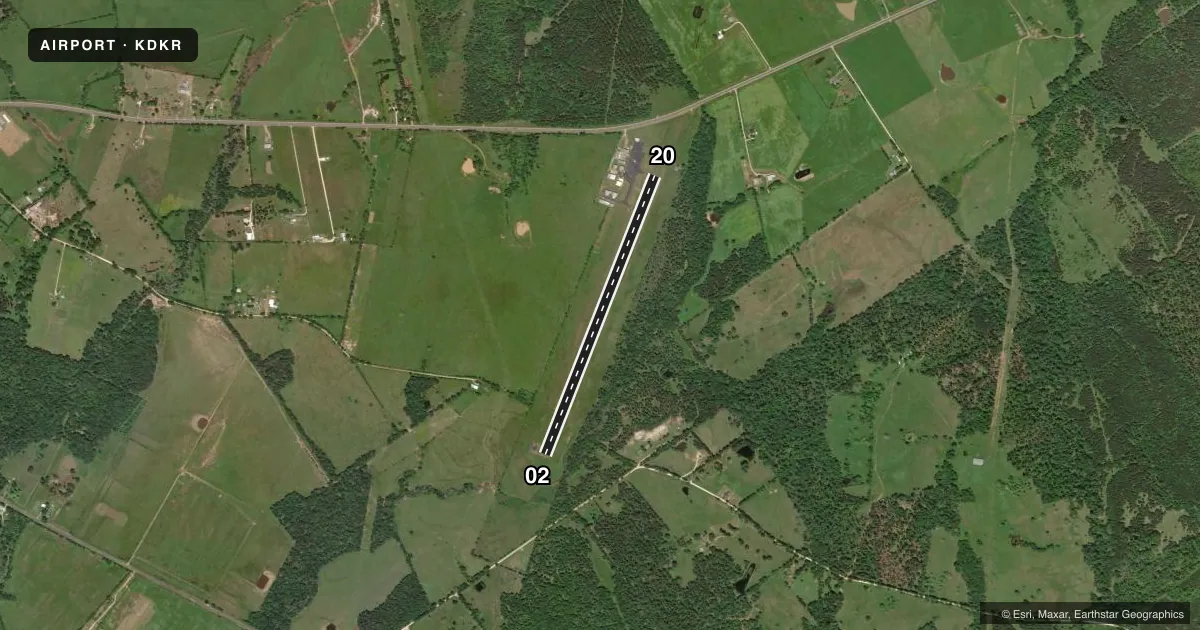
Runways & pattern
Full pagePattern entry · RWY 02
LEFT TRAFFICRunway end performance
| End | TORA | TODA | ASDA | LDA | VGSI | Approach lights | Obstruction |
|---|---|---|---|---|---|---|---|
| 02 | — | — | — | — | PAPI 2-box left(3°) | — | 18', tree, 352' from thr, 263' R of cntrln, slope 8 |
| 20 | — | — | — | — | PAPI 2-box left(3°) | — | 21', road, 620' from thr, 320' R of cntrln, slope 20 |
Declared distances in feet. TORA = takeoff run available, TODA = takeoff distance, ASDA = accelerate-stop, LDA = landing distance.
Airport sketch
Runways drawn to scale from FAA survey coordinates, rendered over satellite imagery. Not for navigation.
Approaches & charts
Services on the field
Fuel grades, oxygen, maintenance, ramp storage and lighting — as declared to the FAA by the airport operator.
Fuel & services
- Fuel
- 100LL
- Oxygen (bottled)
- Not available
- Oxygen (bulk)
- Not available
- Airframe repair
- Major
- Power plant repair
- Major
- Other services
- AGRI
Ramp & ground
- Transient storage
- Tie-down
- Landing fee
- No fee published
- Customs
- Not available
- Lighting schedule
- SEE RMK
- Beacon schedule
- SS-SR
- Beacon
- White / Green (civil land)(WG)
- Wind indicator
- Lighted
- Segmented circle
- Yes
Fuel & FBOs
Cheapest 100LL and Jet A on the field and nearby. Always confirm with the FBO before taxi.
Airport notes
Surface conditions, obstructions, local procedures, lighting outages and other notes published with each FAA cycle.
General notes
- FOR CD CTC HOUSTON ARTCC AT 281-230-5622.
Lighting notes
- MIRL RY 02/20 PRESET LOW INTST; TO INCR INTST ACTVT - CTAF. MIRLS OPER WITH PHOTOCELL OPERG ONLY AT NIGHT WITH SLCTBL INTST ON CTAF.
Fuel notes
- 100LLSELF SERVE FUEL.
Approach & departure obstructions
- 028 FT TREES, 120 FT DSTC, 180 FT R.
- 02PAPI OTS INDEFLY.
- 20PAPI OTS INDEFLY.
- 02ALSO 50 FT TREES, 1200 FT DSTC, 20:1.
Other notes
- MANAGERCOUNTY JUDGE
- MANAGEREXTENSION 221.
- OWNEREXT 221
VFR map & nearby airports
VFR sectional. Tap any ICAO chip to open that airport.
Key facts · KDKR
Answer card- ICAO
- KDKR
- Name
- HOUSTON COUNTY
- Location
- CROCKETT, TEXAS
- Elevation
- 348.4 ft MSL
- Traffic pattern altitude
- 1,348.4 ft MSL (1,000 AGL)
- Control tower
- Non-towered (use CTAF)
- Total runways
- 1
- Longest runway
- 02/20 · 4,000 ft
- Published ILS approaches
- 0
- Published frequencies
- 1
- Magnetic variation
- 5°
- Current flight rules
- VFR
- Current wind
- 000° at 0 kt
- Favored runway now
- –
Houston County Airport sits in Crockett, Texas. Field elevation is 348.4 ft MSL. The airport has one runway. Runway 02/20 is 4,000 ft long with an asphalt surface. There is no control tower. CTAF is 122.9. No ILS approaches are published here.
Pattern altitude is not published. Use the standard 1,000 ft AGL pattern for light piston operations unless the current FAA Chart Supplement says otherwise. The published remarks matter here. Runway 02 has trees near the departure end. There is a closer set off the right side. Taller trees sit farther out on a 20:1 slope. The PAPI on both runway ends is out of service indefinitely. Runway lights are medium intensity. They start at low intensity. You can raise them on the CTAF. At night they use a photocell with selectable intensity on the CTAF.
Houston County Airport is a non-towered field, so expect self-announce traffic and keep a close scan in the pattern. Houston County Airport is the on-field FBO. It carries 100LL. Self-serve 100LL is available. For clearance delivery, contact Houston Air Route Traffic Control Center. If you need the latest operational details, check the current FAA Chart Supplement or call the airport operator or FBO directly.