METAR & TAF KLFK
Current METAR
Observed 06:53Z
KLFK 270653Z AUTO 18004KT 10SM CLR 26/24 A2998 RMK AO2 SLP148 T02610244 $
- Wind
- 180° @ 4 kt
- Visibility
- 10 SM
- Temp / Dew
- 26°C / 24°C
- Altimeter
- 29.98 inHg
- Clouds
- CLR
- Density alt
- 1,612 ft
- Ceiling
- Unlimited
- Rules
- VFR
Airport info & contacts
Manager on record, flight service, ARTCC, attendance schedule and pattern altitude — published by the FAA and refreshed every 28 days.
Location
- From city
- 7 NM SW
- VFR sectional
- HOUSTON
- ARTCC
- ZHU · HOUSTON
- NOTAM facility
- LFK (NOTAM-D)
Airport manager
- Name
- GARY LETNEY
- Phone
- 936-634-7511
- Address
- 800 AIRPORT BLVD., DIBOLL TX 75941
Flight service · Hours
- FSS CXO
- MONTGOMERY COUNTY1-800-WX-BRIEF
- Attendance
- MON-FRI · 0700-1900
- SAT-SUN · 0900-1900
Frequencies
Tap any row to copy the frequency to your clipboard.
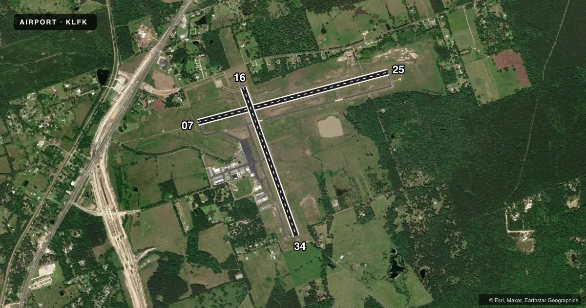
Runways & pattern
Full pagePattern entry · RWY 16
LEFT TRAFFIC| Runway | Heading (°M) | Length | Surface | Traffic |
|---|---|---|---|---|
| 07/25 | 73° / 253° | 5,400 ft | ASPH | Standard L |
| 16/34Favored | 158° / 338° | 4,311 ft | ASPH | Standard L |
Runway end performance
| End | TORA | TODA | ASDA | LDA | VGSI | Approach lights | Obstruction |
|---|---|---|---|---|---|---|---|
| 07 | — | — | — | — | — | MALSR | 90', tree, 3320' from thr, 210' R of cntrln, slope 34 |
| 25 | — | — | — | — | PAPI 4-box left(3°) | — | 75', trees, 530' from thr, 530' R of cntrln, slope 4 |
| 16 | — | — | — | — | VASI 4-box left(3°) | — | 63', tree, 656' from thr, 190' R of cntrln, slope 7 |
| 34 | — | — | — | — | VASI 4-box left(3°) | — | 53', trees, 855' from thr, 170' R of cntrln, slope 12 |
Declared distances in feet. TORA = takeoff run available, TODA = takeoff distance, ASDA = accelerate-stop, LDA = landing distance.
Airport sketch
Runways drawn to scale from FAA survey coordinates, rendered over satellite imagery. Not for navigation.
Approaches & charts
ILS · 1
Services on the field
Fuel grades, oxygen, maintenance, ramp storage and lighting — as declared to the FAA by the airport operator.
Fuel & services
- Fuel
- 100LLA+
- Oxygen (bottled)
- Not available
- Oxygen (bulk)
- Not available
- Airframe repair
- Major
- Power plant repair
- Major
- Other services
- AVNCS
Ramp & ground
- Transient storage
- Tie-down
- Hangar
- Landing fee
- No fee published
- Customs
- Not available
- Lighting schedule
- SEE RMK
- Beacon schedule
- SS-SR
- Beacon
- White / Green (civil land)(WG)
- Wind indicator
- Lighted
- Segmented circle
- Yes
Fuel & FBOs
Cheapest 100LL and Jet A on the field and nearby. Always confirm with the FBO before taxi.
Airport notes
Surface conditions, obstructions, local procedures, lighting outages and other notes published with each FAA cycle.
General notes
- RWY 34 100 FT X 199 FT PAVED SAFETY AREA.
- FOR CD IF UNA TO CTC ON FSS FREQ, CTC HOUSTON ARTCC AT 281-230-5622.
Lighting notes
- DUSK-DAWN. MIRL RWYS 07/25 & 16/34 PRESET MED INTST; TO INCR INTST AND ACTVT MALSR RWY 07 - CTAF.
Fuel notes
- 100LLSVC FEE CHRGD FOR FUEL AFT 1900; CALL 936-635-1542.
Runway surface & condition
- 16/34296 FT PAVED SWY NW END.
Approach & departure obstructions
- 34OBSTN CLNC 20:1 TO DSPLCD THR.
Other notes
- UNICOM MNT FM 0700-1900.
VFR map & nearby airports
VFR sectional. Tap any ICAO chip to open that airport.
Key facts · KLFK
Answer card- ICAO
- KLFK
- Name
- ANGELINA COUNTY
- Location
- LUFKIN, TEXAS
- Elevation
- 295.6 ft MSL
- Traffic pattern altitude
- 1,295.6 ft MSL (1,000 AGL)
- Control tower
- Non-towered (use CTAF)
- Total runways
- 2
- Longest runway
- 07/25 · 5,400 ft
- Published ILS approaches
- 1
- Published frequencies
- 2
- Magnetic variation
- 2°
- Current flight rules
- VFR
- Current wind
- 180° at 4 kt
- Favored runway now
- RWY 16
Angelina County Airport is in Lufkin, Texas. Field elevation is 295.6 ft MSL. The airport has two asphalt runways. Runway 07/25 is the longest at 5,400 ft. Runway 16/34 is 4,311 ft. There is no control tower. CTAF and UNICOM are both 123.0. UNICOM is monitored from 0700 to 1900.
One ILS approach is published for runway 07. Pattern altitude is not published, so use the standard 1,000 ft AGL for light piston traffic unless the current Chart Supplement says otherwise. The on-field FBO is Angelina County Airport. It carries 100LL and Jet A Prist. Call ahead if you need fuel after 1900. A service fee applies then. Runway 07 has medium intensity approach lighting with runway alignment indicator lights. Use CTAF to increase intensity and activate that system from dusk to dawn.
A few runway notes matter here. Runway 34 has a paved safety area. There is also a 296-foot paved stopway at the northwest end of runway 16/34. The published obstacle clearance slope to the displaced threshold of runway 34 is 20 to 1. For clearance delivery, if you cannot reach flight service, contact Houston ARTCC. First-time pilots should plan for an uncontrolled field with active lighting procedures and review the current Chart Supplement before arrival.