METAR & TAF 78R
78R does not publish a METAR.
Showing the nearest reporting station: KOCH (NACOGDOCHES A L MANGHAM JR RGNL) · 27.7 NM away. Conditions at 78R may differ.
METAR · KOCH
Observed 05:56Z
KOCH 270556Z AUTO 18004KT CLR 27/24 A3000 RMK AO2 SLP157 T02670239 10339 20244 403560228 50005 PWINO TSNO RVRNO $
- Wind
- 180° @ 4 kt
- Visibility
- —
- Temp / Dew
- 27°C / 24°C
- Altimeter
- 30.00 inHg
- Clouds
- CLR
- Density alt
- 1,890 ft
- Ceiling
- Unlimited
- Rules
- VFR
Airport info & contacts
Manager on record, flight service, ARTCC, attendance schedule and pattern altitude — published by the FAA and refreshed every 28 days.
Location
- From city
- 3 NM W
- VFR sectional
- HOUSTON
- ARTCC
- ZHU · HOUSTON
- NOTAM facility
- CXO (NOTAM-D)
Airport manager
- Name
- JEFF BOYD
- Phone
- 936-275-2762
- Address
- 100 W. COLUMBIA, SAN AUGUSTINE TX 75972
Flight service · Hours
- FSS CXO
- MONTGOMERY COUNTY1-800-WX-BRIEF
- Attendance
- Unattended
Frequencies
Tap any row to copy the frequency to your clipboard.
Runways & pattern
Full pagePattern entry · RWY 17
LEFT TRAFFICRunway end performance
| End | TORA | TODA | ASDA | LDA | VGSI | Approach lights | Obstruction |
|---|---|---|---|---|---|---|---|
| 17 | — | — | — | — | — | — | 65', trees, 388' from thr, 145' R of cntrln, slope 2 |
| 35 | — | — | — | — | — | — | 10', fence, 210' from thr, 55' R of cntrln, slope 1 |
Declared distances in feet. TORA = takeoff run available, TODA = takeoff distance, ASDA = accelerate-stop, LDA = landing distance.
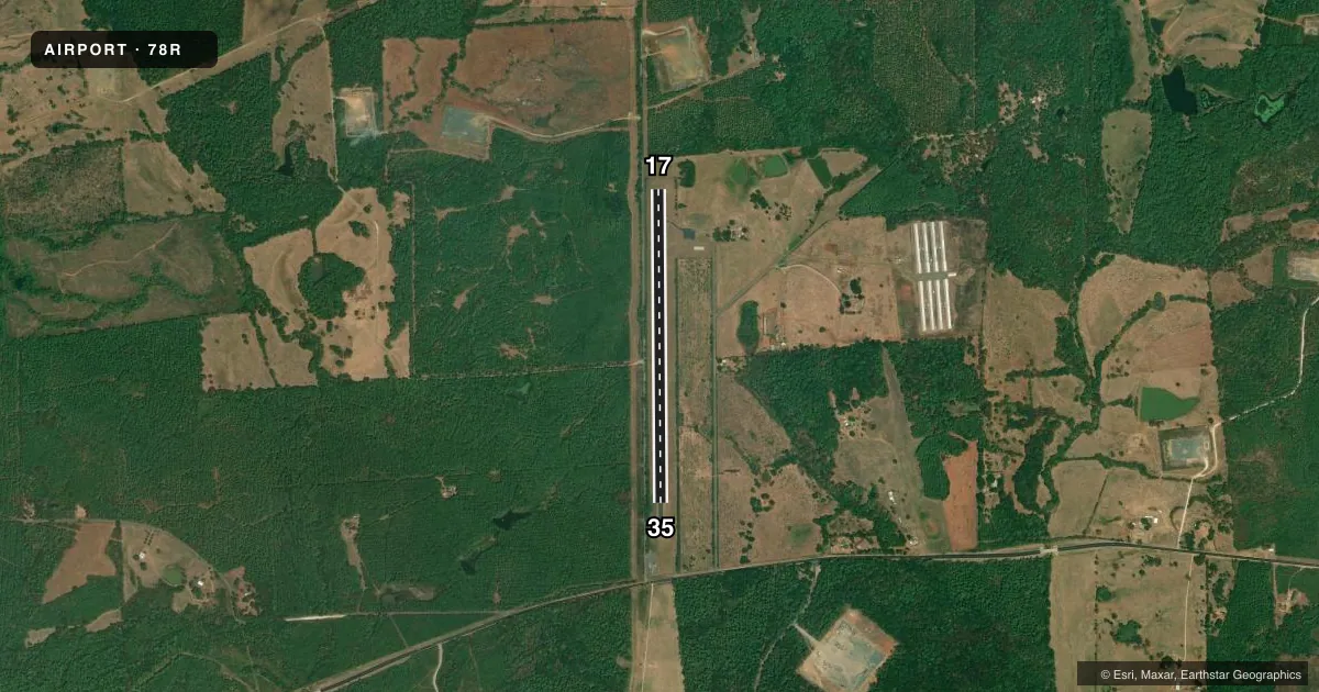
Airport sketch
Runways drawn to scale from FAA survey coordinates, rendered over satellite imagery. Not for navigation.
Approaches & charts
Services on the field
Fuel grades, oxygen, maintenance, ramp storage and lighting — as declared to the FAA by the airport operator.
Fuel & services
- Fuel
- Not available
- Oxygen (bottled)
- Not available
- Oxygen (bulk)
- Not available
- Airframe repair
- Not available
- Power plant repair
- Not available
Ramp & ground
- Transient storage
- Not published
- Landing fee
- No fee published
- Customs
- Not available
- Lighting schedule
- SEE RMK
- Beacon schedule
- SEE RMK
- Beacon
- White / Green (civil land)(WG)
- Wind indicator
- Lighted
- Segmented circle
- Yes
Fuel & FBOs
Cheapest 100LL and Jet A on the field and nearby. Always confirm with the FBO before taxi.
Airport notes
Surface conditions, obstructions, local procedures, lighting outages and other notes published with each FAA cycle.
General notes
- FOR CD CTC HOUSTON ARTCC AT 281-230-5622.
- NO LINE OF SIGHT BETWEEN RWY ENDS.
Lighting notes
- ACTVT ROTG BCN - CTAF.
- MIRL RWY 17/35 PRESET LOW INTST, TO INCR INTST ACTVT - CTAF.
Approach & departure obstructions
- 1710 FT BRUSH, 130 FT DSTC, 125 FT L/R.
- 17CTLNG OBSTN EXCEEDS A 45 DEG SLOPE. APCH SLOPE 7:1 TO DSPLCD THLD.
Other notes
- MANAGERCOUNTY JUDGE
- MANAGEREMERG PHONE: 936-275-2424, SHERIFF OFC.
- 17/35CRACKING, POTHOLES LOOSE STONES.
VFR map & nearby airports
VFR sectional. Tap any ICAO chip to open that airport.
Key facts · 78R
Answer card- ICAO
- 78R
- Name
- SAN AUGUSTINE COUNTY
- Location
- SAN AUGUSTINE, TEXAS
- Elevation
- 443 ft MSL
- Traffic pattern altitude
- 1,443 ft MSL (1,000 AGL)
- Control tower
- Non-towered (use CTAF)
- Total runways
- 1
- Longest runway
- 17/35 · 3,800 ft
- Published ILS approaches
- 0
- Published frequencies
- 1
- Magnetic variation
- 5°
- Current flight rules
- VFR
- Current wind
- 180° at 4 kt
- Favored runway now
- RWY 17
San Augustine County Airport (78R) sits in San Augustine, Texas. Field elevation is 443 ft MSL. The airport has one runway. Runway 17/35 is 3,800 ft long with an asphalt surface. There is no control tower. CTAF is 122.9. No ILS approaches are published here.
Pattern altitude is not published. Use the standard 1,000 ft AGL pattern unless the current Chart Supplement or local guidance says otherwise. The published remarks matter here. Runway 17/35 has cracking, potholes and loose stones. There is also no line of sight between the runway ends. Runway 17 has a controlling obstruction near the approach path. The published slope to the displaced threshold is 7 to 1. Brush is also noted near runway 17. The rotating beacon and the medium intensity runway lights are activated by the CTAF. Lights come up at low intensity by default.
There are no on-field FBOs listed. Plan on self-briefing the field before arrival. If you need current operational detail, call the airport operator or check the current FAA Chart Supplement. For clearance delivery, Houston ARTCC is listed in the remarks. The airport manager is the county judge. The emergency phone listed in the remarks is the sheriff office at 936-275-2424.